Prestwich-cum-Oldham

Last updated

Prestwich-cum-Oldham
Parish Church of St Mary, Prestwich.png
Church of St Mary the Virgin, Prestwich
Prestwich cum Oldham.svg
Area
21,625 acres (87.51 km2)
Population
  185194,470
  1861117,961
History
  Created High Middle Ages
  Abolished20th century
  Succeeded by Prestwich
Oldham
(parishes)
Status Ecclesiastical parish
   HQ Church of St Mary the Virgin, Prestwich
Subdivisions
  Type Townships
  Units Alkrington, Chadderton, Crompton, Great Heaton, Little Heaton, Oldham, Pilkington, Prestwich, Royton, Tonge

Prestwich-cum-Oldham (also known as Prestwich with Oldham) [1] [2] was an ancient ecclesiastical parish of the hundred of Salford, within the historic county boundaries of Lancashire, England. With the Parish Church of St Mary the Virgin, Prestwich as its centre, this parish encompassed a total of ten townships, [2] and within them, several smaller chapelries.

Contents

Prestwich-cum-Oldham was divided into two non-contiguous sections: the townships of Great Heaton, Little Heaton, Pilkington, and Prestwich on the west; Alkrington, Tonge, Chadderton, Crompton, Oldham and Royton on the east. The parish of Middleton divided these two portions of Prestwich-cum-Oldham from north to south. The parish covered 21,625 acres (87.51 km2) and was noted in 1851 to have a population of 94,470, and again in 1861, to have 117,987. [3]

History

The parish of Prestwich-cum-Oldham has "no united history", [2] and instead was a loose affiliation of rural townships between the South Pennines and West Pennine Moors that had one early-medieval church building between them. Prestwich-cum-Oldham traces its existence to the colony of priests whose presence gave Prestwich its name, as well as tithes, levies and terms of land-tenure related to the ancient Royal Manor of Tottington, a unit used for governance in the manorial system that spanned most of the territory. [2] Stretching for 13 miles (21 km) from east to west from the High Middle Ages onwards, Prestwich-cum-Oldham was probably larger in extent in earlier times; documents suggest an ecclesiastical connection with Radcliffe and Middleton. [2] Manorialism in the parish was comparatively weak when compared nationally; ruling families were either non-resident or of "only local importance". [2] An exception was the Pilkingtons, from the western portion of the parish, who ranked "among the great families of the county". [2] Their military allegiance to Richard III and the House of York during the Wars of the Roses, though, brought about their overthrow in the late-15th century. [2]

The rector of Prestwich-cum-Oldham "was at first reluctantly compliant and then an avowed opponent" of the Elizabethan Religious Settlement of 1559. [2] There is, though, little other evidence of opposition to the English Reformation and the established church. Nevertheless, it is one of only a few parishes in England in which any resistance occurred; there was a show of popular support for the abolition of the Book of Common Prayer and Episcopal polity in favour of Presbyterian polity supported by presbyters in the parish of Manchester. [2] By 1662, the rector of Prestwich-cum-Oldham complied with Anglicanism, but the curate of Oldham, St Mary's was expelled for preaching nonconformism; chapels at Stand and Greenacres span virtually the whole history of non-conformity in the United Kingdom, as does a Quaker meeting-house at Royton. [2]

The parish remained comparatively rural until the Industrial Revolution; some townships, such as Royton, had primitive domestic manufactories and traded goods at the markets in Rochdale and Manchester. The introduction of the factory system to Oldham, Chadderton, Crompton and Royton led to the demise of arable land via rapid urbanisation and industrialisation. This gave rise to the eastern portion as the dominant partner of the parish, despite it being under the authority of the church at Prestwich.

Objections to Prestwich's dominance of the parish existed from an early time; there had been a chapel of ease at Crompton since at least the early 16th century but, due to ecclesiastical arrangements in Prestwich-cum-Oldham, the inhabitants were obliged to contribute money towards Oldham Church, which in turn had obligation to the mother Church of St Mary the Virgin at Prestwich. [4] On several occasions during the 15th and 16th centuries, the Archdeacon of the Chester had to intervene because Crompton's inhabitants refused to contribute monies towards holy bread and candles used at Prestwich. [4]

The Parish of Prestwich-cum-Oldham was dissolved in the 20th century.

Churches and rituals

The Church of St Mary the Virgin, Prestwich was the parish church of Prestwich-cum-Oldham, used for baptisms, marriages and burials. It is one of the Grade I listed buildings in Greater Manchester. Prestwich, St Mary's Church.jpg
The Church of St Mary the Virgin, Prestwich was the parish church of Prestwich-cum-Oldham, used for baptisms, marriages and burials. It is one of the Grade I listed buildings in Greater Manchester.

Prestwich-cum-Oldham lay within the Diocese of Lichfield until 1541, when this diocese was divided and Prestwich-cum-Oldham became part of the Diocese of Chester. This in turn was divided in 1847 when the present Diocese of Manchester was created.

Many of Prestwich-cum-Oldham's townships had no medieval church of their own. For baptisms, marriages and burials, the people had to travel to St Mary's, Prestwich, or else churches that lay outside the parish boundaries, such as St Leonard's, Middleton. Oldham, though remaining nominally a chapelry into the 20th century, effectively secured independence for the eastern portion of Prestwich-cum-Oldham.

Constituent areas

Prestwich-cum-Oldham comprised ten townships during the greater part of its history. These were not static, and changed according to the construction of churches and chapels and increases in population. Similarly, Prestwich-cum-Oldham was later split into two separate parishes of Prestwich and Oldham.

The area of the whole is 22,022½ acres. The geology of the entire parish is represented by the Coal Measures, and on the eastward side of a line drawn from High Crompton to Greenacres, of the Lower Coal Measures or Gannister Beds.

ParishTownshipArea
(In 1911)
NotesRef(s).
Prestwich-cum-Oldham Alkrington 797 acres (3.23 km2)
Chadderton 3,138 acres (12.70 km2)
Crompton 2,864.5 acres (1,159.2 ha)
Great Heaton 875 acres (3.54 km2)
Little Heaton 532 acres (2.15 km2)
Oldham 4,665 acres (18.88 km2)
Pilkington 5,469 acres (22.13 km2)
Prestwich 1,917.5 acres (776.0 ha)
Royton 1,372 acres (5.55 km2)The suburb of Thornham formed its own township, and lay within the parish of Middleton.
Tonge 392 acres (1.59 km2)

Daughter parishes

Prestwich-cum-Oldham was split into some forty-one daughter parishes, which can be found at The Prestwich Guide - History.

Neighbouring parishes


See also

Related Research Articles

Chadderton Human settlement in England

Chadderton is a town within the Metropolitan Borough of Oldham, in Greater Manchester, England. It lies along the course of the River Irk and the Rochdale Canal, on undulating land in the foothills of the Pennines, 1 mile (1.6 km) west of Oldham, 4.5 miles (7.2 km) south of Rochdale and 6 miles (9.7 km) northeast of the city of Manchester.

Glodwick Human settlement in England

Glodwick is an area of Oldham, Greater Manchester, England. It is south-east of Oldham town centre.

Middleton, Greater Manchester Human settlement in England

Middleton is a town in the Metropolitan Borough of Rochdale, Greater Manchester, England, on the River Irk 5 miles (8.0 km) southwest of Rochdale and 4.8 miles (7.7 km) northeast of Manchester city centre. Middleton had a population of 42,972 at the 2011 Census. It lies on the northern edge of Manchester, with Blackley to the south and Moston to the south east.

Royton Human settlement in England

Royton is a town in the Metropolitan Borough of Oldham, Greater Manchester, England, with a population of 21,284 in 2011. Close to the source of the River Irk, near undulating land at the foothills of the South Pennines, it is 1.7 miles (2.7 km) northwest of Oldham, 3.2 miles (5.1 km) southeast of Rochdale and 7.6 miles (12.2 km) northeast of Manchester.

Prestwich Human settlement in England

Prestwich is a suburban town in the Metropolitan Borough of Bury, Greater Manchester, England, 3.3 miles (5.3 km) north of Manchester city centre, 3.1 miles (5 km) north of Salford and 4.7 miles (7.6 km) south of Bury.

Hollinwood, Greater Manchester Human settlement in England

Hollinwood is an area and electoral ward of the Metropolitan Borough of Oldham, Greater Manchester, England. The population at the 2011 census was 10,920.

Shaw and Crompton Human settlement in England

Shaw and Crompton is a town and civil parish within the Metropolitan Borough of Oldham, in Greater Manchester, England. It lies on the River Beal at the foothills of the South Pennines, 2.3 miles (3.7 km) north of Oldham, 3.6 miles (5.8 km) southeast of Rochdale, and 8.7 miles (14 km) to the northeast of the city of Manchester. It is regularly referred to as Shaw.

County Borough of Oldham

Oldham was, from 1849 to 1974, a local government district in the northwest of England coterminous with the town of Oldham.

Coldhurst Human settlement in England

Coldhurst is an area of Oldham and an electoral ward of the wider Metropolitan Borough of Oldham in Greater Manchester, England. At the time of the United Kingdom Census 2001, it had a population of 11,935, increasing to 13,201 at the 2011 Census. The electoral ward spans most of Oldham's town centre, although the name Coldhurst conventionally applies to the area immediately north of the centre. The district of Westwood and a small adjoining part of Chadderton in the Busk area also lie within the Coldhurst ward district.

Werneth, Greater Manchester Human settlement in England

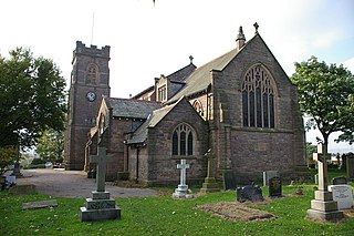
Werneth is an area of Oldham, Greater Manchester, England. The population at the 2011 census was 12,348. It is 1 mile (1.6 km) west-southwest of Oldham's commercial centre and one of its most ancient localities. It is contiguous with Westwood, Hollinwood, Hollins and Chadderton. Werneth includes Freehold between Werneth Park and Oldham's border with Chadderton at Block Lane.

Prestwich was a constituency in the county of Lancashire of the House of Commons for the Parliament of the United Kingdom. Created by the Redistribution of Seats Act 1885, it was represented by one Member of Parliament. The constituency was abolished in 1918.

Royton Urban District

Royton was a local government district from 1863 to 1974 in Lancashire, England, which covered the modern-day town of Royton, and its suburbs and districts.

Waterhead, Greater Manchester Human settlement in England

Waterhead, is an area of Oldham, and an electoral ward of the Metropolitan Borough of Oldham, in Greater Manchester, England. Historically in Lancashire, an upland area in the Pennines, the ward of Waterhead has population of 12,876, decreasing to 12,029 at the 2011 Census.

Rochdale (ancient parish)

Rochdale was an ecclesiastical parish of early-medieval origin in northern England, administered from the Church of St Chad, Rochdale. At its zenith, it occupied 58,620 acres (237 km2) of land amongst the South Pennines, and straddled the historic county boundary between Lancashire and the West Riding of Yorkshire. To the north and north-west was the parish of Whalley; to the southwest was the parish of Bury; to the south was Middleton and Prestwich-cum-Oldham.

Sholver Human settlement in England

Sholver is an area of Oldham, in Greater Manchester, England. An elevated, residential area, it lies near the middle of the Oldham part of the valley of the River Beal, 2.1 miles (3.4 km) northeast of Oldham's commercial centre, nearly at the northeasternmost extremity of the town, by open countryside close to the source of the River Medlock and by the border with Saddleworth.
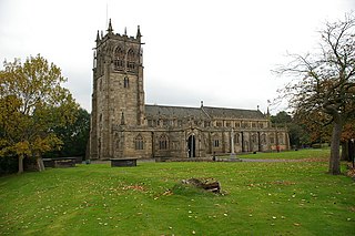
Oldham Parish Church Church in Greater Manchester, United Kingdom

The Church of St. Mary with St. Peter, mostly known as Oldham Parish Church, is the Church of England parish church for Oldham in Greater Manchester, England. It forms part of the Diocese of Manchester, and is one of several Grade II* listed buildings in Greater Manchester.

Pilkington was a township in the parish of Prestwich-cum-Oldham, hundred of Salford and county of Lancashire, in northern England.

Nimble Nook Human settlement in England


Nimble Nook is a locality in the town of Chadderton in the Metropolitan Borough of Oldham, Greater Manchester.

References

Notes

  1. "Greater Manchester Gazetteer". Greater Manchester County Record Office. Places names - O to R. Archived from the original on 18 July 2011. Retrieved 20 June 2007.
  2. 1 2 3 4 5 6 7 8 9 10 11 Brownbill & Farrer 1911 , pp. 67–76.
  3. Prestwich CP/AP through time | Descriptive Gazetteer entries Archived 1 October 2007 at the Wayback Machine
  4. 1 2 "An ancient township called Crompton...", Oldham Evening Chronicle , p. 8, 29 February 2008

Bibliography

  • Brownbill, John; Farrer, William (1911), A History of the County of Lancaster: Volume 5; edited by W. Farrer & J. Brownbill (Victoria County History), London: Constable, ISBN   978-0-7129-1055-2