Glodwick is an area of Oldham, Greater Manchester, England. It is south-east of Oldham town centre.

Failsworth is a town in Greater Manchester, England, 4 miles (6.4 km) north-east of Manchester and 3 miles (4.8 km) south-west of Oldham. The orbital M60 motorway skirts it to the east. The population at the 2011 census was 20,680. Historically in Lancashire, Failsworth until the 19th century was a farming township linked ecclesiastically with Manchester. Inhabitants supplemented their farming income with domestic hand-loom weaving. The humid climate and abundant labour and coal led to weaving of textiles as a Lancashire Mill Town with redbrick cotton mills. A current landmark is the Failsworth Pole. Daisy Nook is a country park on the southern edge.

Saddleworth is a civil parish of the Metropolitan Borough of Oldham in Greater Manchester, England. It comprises several villages and hamlets as well as suburbs of Oldham on the west side of the Pennine hills.

Rochdale is a town in Greater Manchester, England, and the administrative centre of the Metropolitan Borough of Rochdale. In the 2021 census the town had a population of 111,261, compared to 223,773 for the wider borough. Rochdale is in the foothills of the South Pennines and lies in the dale (valley) of the River Roch, 5 miles (8 km) northwest of Oldham, and 10 miles (16 km) northeast of Manchester.

The Metropolitan Borough of Oldham is a metropolitan borough of Greater Manchester in England. It is named after its largest town, Oldham. The borough had a population of 243,912 in 2022, making it the sixth-largest district by population in Greater Manchester. The borough spans 142 square kilometres (55 sq mi).

Middleton is a town in the Metropolitan Borough of Rochdale, Greater Manchester, England, on the River Irk. It is 5 miles (8.0 km) southwest of Rochdale and 5 miles (8.0 km) northeast of Manchester. Middleton had a population of 42,972 at the 2011 Census. It lies on the northern edge of Manchester, with Blackley to the south and Moston to the south east.

Royton is a town in the Metropolitan Borough of Oldham, Greater Manchester, England, with a population of 21,284 in 2011. Close to the source of the River Irk, near undulating land at the foothills of the South Pennines, it is 2 miles (3.2 km) northwest of Oldham, 3 miles (4.8 km) southeast of Rochdale and 8 miles (12.9 km) northeast of Manchester.
The Oldham Loop Line was a suburban-line in Greater Manchester, England, used by trains that ran from Manchester Victoria to Rochdale via Oldham Mumps. Services on the line at the time of its closure were operated by Northern Rail.

Shaw and Crompton is a civil parish in the Metropolitan Borough of Oldham, Greater Manchester, England, and lies on the River Beal at the foothills of the South Pennines. It is located 2.3 miles (3.7 km) north of Oldham, 3.6 miles (5.8 km) south-east of Rochdale and 8.7 miles (14 km) north-east of Manchester. Its largest settlement is Shaw.

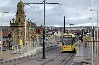
Shaw and Crompton is a tram stop on the Oldham and Rochdale Line (ORL) of Greater Manchester's light-rail Metrolink system. It opened to passengers on 16 December 2012 and is located in Shaw and Crompton, a part of the Metropolitan Borough of Oldham, England.

Hollinwood tram stop is a tram stop and park & ride site on the Manchester Metrolink Oldham and Rochdale Line in Hollinwood, Greater Manchester, England. It was formerly a railway station before its conversion to a tram stop between 2009 and 2012.

Failsworth tram stop is a Manchester Metrolink tram stop on the Oldham and Rochdale Line serving the town of Failsworth, Greater Manchester, England. It was formerly a railway station before its conversion to Metrolink in 2012.

Central Park is a tram stop on the Oldham and Rochdale Line (ORL) of Greater Manchester's light rail Metrolink system. It opened to passengers on 13 June 2012 as part of Phase 3a of Metrolink's expansion, and is located in the Newton Heath area of Manchester, England.

Denshaw is a village in the civil parish of Saddleworth in the Metropolitan Borough of Oldham, in Greater Manchester, England. It lies by the source of the River Tame, high amongst the Pennines above the village of Delph, 4.6 miles (7.4 km) northeast of Oldham,3.3 miles (5.3 km) north-northwest of Uppermill and Shaw and Crompton. It has a population of around 500.

Trent Mill was a cotton spinning mill on Duchess Street in Shaw and Crompton, Greater Manchester, England. It was built by F.W. Dixon & Son in 1908. It closed and was taken over by the Lancashire Cotton Corporation in 1929 reopened in 1938 and closed again in 1962, and was demolished in 1967.

Rutland Mill was a cotton spinning mill on Linney Lane, in Shaw and Crompton, Greater Manchester, England. It was built by F. W. Dixon & Son in 1907 for the Rutland Mill Co. Ltd. It was taken over by the Lancashire Cotton Corporation in 1935. By 1964, it was in the Courtaulds Group. In the late 1980s, as Courtaulds moved operations to other parts of the world, the mill was bought by Littlewoods who demolished it and replaced it with a new automated storage warehouse.

Hawk Mill, Shaw was a cotton spinning mill in Shaw, Oldham, Greater Manchester. It was built in 1908. It was taken over by the Lancashire Cotton Corporation in the 1931 and passed to Courtaulds in 1964. The mill closed in 1967, and was demolished in 1991.

Newton Heath and Moston is a Manchester Metrolink tram stop on the Oldham and Rochdale Line (ORL), in the Newton Heath area of Manchester, England.

Greater Manchester Bus route 58 was operated by First Greater Manchester between Rochdale and Middleton bus stations via Milnrow, Newhey, Shaw & Crompton, Oldham and Chadderton. It had a sister route 59 which operated on the same route between Middleton and Shaw, and also served Rushcroft. The route was curtailed to run between Rochdale and Oldham in 2017 and was withdrawn in 2020 during the Coronavirus pandemic. The route is now covered by services 57 and 182.
The Oldham and Rochdale Line (ORL) is a light rail/tram line on the Manchester Metrolink in Greater Manchester, running from North Manchester to Rochdale town centre via Oldham, reusing most of the trackbed of the former Oldham Loop railway line which closed in 2009. The line was re-opened in a modified form as a tramway from 2012 – 2014, as part of Phase 3 of the Metrolink's expansion.

