
Bundesautobahn 60 is an autobahn in Germany. During its entire course it forms a part of the E 42.

Kubryk is a village in the administrative district of Gmina Krośnice, within Milicz County, Lower Silesian Voivodeship, in south-western Poland. Prior to 1945 it was in Germany.
Bielska Struga is a village in the administrative district of Gmina Tuchola, within Tuchola County, Kuyavian-Pomeranian Voivodeship, in north-central Poland. It lies approximately 11 kilometres (7 mi) north-east of Tuchola and 61 km (38 mi) north of Bydgoszcz.
Czepiec is a village in the administrative district of Gmina Wałcz, within Wałcz County, West Pomeranian Voivodeship, in north-western Poland. It lies approximately 17 kilometres (11 mi) north-west of Wałcz and 115 km (71 mi) east of the regional capital Szczecin.
Nakielno is a village in the administrative district of Gmina Wałcz, within Wałcz County, West Pomeranian Voivodeship, in north-western Poland. It lies approximately 11 kilometres (7 mi) west of Wałcz and 116 km (72 mi) east of the regional capital Szczecin.
Rudnik-Kolonia is a village in the administrative district of Gmina Wilkołaz, within Kraśnik County, Lublin Voivodeship, in eastern Poland. It lies approximately 9 kilometres (6 mi) north-east of Kraśnik and 37 km (23 mi) south-west of the regional capital Lublin.
Kleszczów is a village in Bełchatów County, Łódź Voivodeship, in central Poland. It is the seat of the gmina called Gmina Kleszczów. It lies approximately 17 kilometres (11 mi) south of Bełchatów and 64 km (40 mi) south of the regional capital Łódź.

Köyük is a village in the Yevlakh Rayon of Azerbaijan. The village forms part of the municipality of Qaramanlı.
Jelna-Judaszówka is a village in the administrative district of Gmina Nowa Sarzyna, within Leżajsk County, Subcarpathian Voivodeship, in south-eastern Poland. It lies approximately 3 kilometres (2 mi) south of Nowa Sarzyna, 10 km (6 mi) north-west of Leżajsk, and 38 km (24 mi) north-east of the regional capital Rzeszów.
Kijowiec-Szyszynek is a village in the administrative district of Gmina Ślesin, within Konin County, Greater Poland Voivodeship, in west-central Poland.
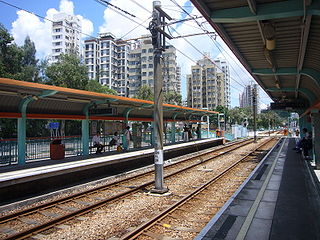
San Hui is one of the MTR Light Rail stops. It is located at ground level at Castle Peak Road next to San Hui Village in Tuen Mun District. It began service on 2 February 1992 and belongs to Zone 2. It serves San Hui Village and Kau Hui San Village.
Rolewice is a village in the administrative district of Gmina Dobiegniew, within Strzelce-Drezdenko County, Lubusz Voivodeship, in western Poland. It lies approximately 4 kilometres (2 mi) east of Dobiegniew, 22 km (14 mi) north-east of Strzelce Krajeńskie, and 46 km (29 mi) north-east of Gorzów Wielkopolski.
Wysieka is a settlement in the administrative district of Gmina Bartoszyce within Bartoszyce County, Warmian-Masurian Voivodeship, in northern Poland; it is close to the border with the Kaliningrad Oblast of Russia. It lies approximately 8 kilometres (5 mi) north-west of Bartoszyce and 60 km (37 mi) north of the regional capital Olsztyn.
Dybówko is a village in the administrative district of Gmina Prostki, within Ełk County, Warmian-Masurian Voivodeship, in northern Poland.
Dzieżgów is a village in the administrative district of Gmina Myślibórz, within Myślibórz County, West Pomeranian Voivodeship, in north-western Poland. It lies approximately 9 kilometres (6 mi) north-east of Myślibórz and 56 km (35 mi) south-east of the regional capital Szczecin.
The Church of St Nicholas is a late Medieval Bulgarian church near the village of Vukovo, Kyustendil Province.

Bogdanovac is a village in the municipality of Babušnica, Serbia. According to the 2002 census, the village has a population of 170 people.
Kusa Vrana is a village in the municipality of Dimitrovgrad, Serbia. According to the 2002 census, the village has a population of 166 people.
Dobrujevac is a village in the municipality of Boljevac, Serbia. According to the 2002 census, the village has a population of 236 people.
Nõmjala is a village in Saaremaa Parish, Saare County in western Estonia.


