
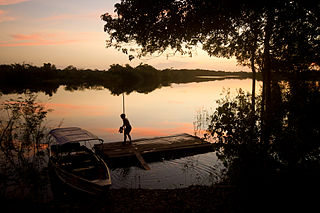
The Rio Negro, or Guainía as it is known in its upper part, is the largest left tributary of the Amazon River, the largest blackwater river in the world, and one of the world's ten largest rivers by average discharge.

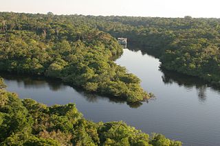
The Jaú National Park is a national park located in the state of Amazonas, Brazil. It is one of the largest forest reserve in South America, and part of a World Heritage Site.

Novo Airão is a municipality located in the state of Amazonas in northern Brazil on the Rio Negro River about 180 km upstream of Manaus. Its population was 19,928 (2020) and its area is 37,771 km². The town is reachable both by river and road.
Demini River is a river in the Amazon rainforest of the state of Amazonas, Brazil. It is a tributary of the Rio Negro.
The Carabinani River (Portuguese: Rio Carabinani is a river in the Amazonas state in north-western Brazil. It is a right tributary of the Jaú River
Jaú River is a river of Amazonas state in north-western Brazil. It is a tributary of the Rio Negro, which itself is a tributary of the Amazon River.
The Unini River is a river of Amazonas state in north-western Brazil. It is a right tributary of the Rio Negro.

Events from the year 2008 in Brazil.
The Serra do Aracá State Park is a state park in the state of Amazonas, Brazil.

The Cuieiras River is a river in the municipality of Maués, Amazonas state, Brazil.
Rio Negro State Park South Section is a State park in the state of Amazonas, Brazil. It protects an area of Amazon rainforest to the east of the Rio Negro that is home to the endangered pied tamarin. The area was reduced in 2001 and was further reduced in 2014 to create a sustainable development reserve for the people that had been living there since before the park was created.
The Rio Negro State Park North Section is a state park in the state of Amazonas, Brazil. It protects an area of Amazon rainforest to the west of the Rio Negro.
The Rio Negro Right Bank Environmental Protection Area is an Environmental protection area (APA) in the state of Amazonas, Brazil.
The Rio Negro Sustainable Development Reserve is a sustainable development reserve (RDS) in the state of Amazonas, Brazil.

The Rio Negro Left Bank Environmental Protection Area is an environmental protection area in the state of Amazonas, Brazil. It protects an area of Amazon rainforest on the left bank of the Rio Negro near Manaus. There is a small human population, and sustainable use of forest resources is allowed. The southern section, near to Manaus, is subject to pressure from poor residents of an official settlement project who clear forest to make charcoal for sale in the city.
The Tarumã Açu River is a river in the state of Amazonas, Brazil. It is a left tributary of the Rio Negro, which it enters just west of the city of Manaus.

The Tarumã Mirim River is a river in the state of Amazonas, Brazil. It is a left tributary of the Rio Negro, which it enters west of the city of Manaus.
Matupiri State Park is a state park in the state of Amazonas, Brazil. It protects a rich area of Amazon rainforest and an ecologically important area of woodland savanna along the Matupiri River. Unusually for a state park, it includes an "indigenous special use zone" that allows the Mura people to continue to fish and extract forest products, as they have for many generations.
The Rio Unini Extractive Reserve is an extractive reserve in the state of Amazonas, Brazil.

The Alto Rio Negro Indigenous Territory is an indigenous territory in the northwest of the state of Amazonas, Brazil. It is in the Amazon biome, and is mostly covered in forest. A number of different ethnic groups live in the territory, often related through marriage, with a total population of over 25,000. There is a long history of colonial exploitation and effective slavery of the indigenous people, and then of attempts to suppress their culture and "civilize" them. The campaign to gain autonomy culminated in creation of the reserve in 1998. The people are generally literate, but health infrastructure is poor and there are very limited economic opportunities.
This page is based on this
Wikipedia article Text is available under the
CC BY-SA 4.0 license; additional terms may apply.
Images, videos and audio are available under their respective licenses.
