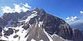
| Punta Nera | |
|---|---|
 North aspect | |
| Highest point | |
| Elevation | 2,847 m (9,341 ft) [1] [2] |
| Prominence | 431 m (1,414 ft) [2] |
| Parent peak | Sorapiss [1] |
| Isolation | 1.77 km (1.10 mi) [1] |
| Coordinates | 46°30′59″N12°11′30″E / 46.516277°N 12.191641°E [1] |
| Geography | |
 Punta Nera Location in Italy 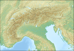 Punta Nera Punta Nera (Alps) | |
 | |
| Interactive map of Punta Nera | |
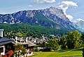
| Country | Italy |
| Province | Belluno |
| Protected area | Dolomites World Heritage Site |
| Parent range | Dolomites Ampezzo Dolomites [1] |
| Topo map | Tabacco 03 Cortina d’Ampezzo e Dolomiti Ampezzane |
| Geology | |
| Rock age | Triassic |
| Rock type | Dolomite |
| Climbing | |
| First ascent | 1876 |
Punta Nera is a mountain in the province of Belluno in northern Italy.