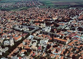
Berettyóújfalu is a town in Hajdú-Bihar county, in center of the Northern Great Plain region of eastern Hungary, near the border with Romania. It is strategically located, being 35 km south of Debrecen, the second largest city in Hungary, and 40 km west of Oradea, the tenth largest city in Romania. Berettyóújfalu is named after the river Berettyó.

European route E 60 is the second-longest road in the International E-road network and runs 8,200 km (5,100 mi), from Brest, France, to Irkeshtam, Kyrgyzstan.

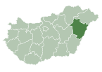
Hajdú–Bihar is an administrative county in eastern Hungary, on the border with Romania. It shares borders with the Hungarian counties Szabolcs-Szatmár-Bereg, Borsod–Abaúj–Zemplén, Jász–Nagykun–Szolnok and Békés. The capital of Hajdú-Bihar county is Debrecen. Together with Bihor County in Romania it constitutes the Biharia Euroregion.

Gyula is a town in Békés County, Hungary. The town is best known for its medieval castle and a thermal bath. Ferenc Erkel, the composer of the Hungarian national anthem, and Albrecht Dürer the Elder, the father of Albrecht Dürer, were also born in Gyula.
Kiskunfélegyháza is a city in Bács-Kiskun County, Hungary.

Controlled-access highways in Hungary are dual carriageways, grade separated with controlled-access, designed for high speeds. The legislation amendments define two types of highways: motorways and expressways.
Seini is a town in Maramureș County, Romania. It administers two villages, Săbișa (Kissebespatak) and Viile Apei (Apahegy). It officially became a town in 1989, as a result of the Romanian rural systematization program.

Tăuții-Măgherăuș is a town in Maramureș County, Romania. The town administers six villages: Băița (Láposbánya), Bozânta Mare (Nagybozinta), Bușag (Buság), Merișor, Nistru (Miszbánya), and Ulmoasa (Szilas). Tăuții-Măgherăuș was declared a town in 2004. The Baia Mare Airport is located in the town.

M4 is a Hungarian expressway which will, upon completion, connect Budapest to Oradea and further Romanian cities. The route will travel in Hungary through Cegléd, Szolnok, Karcag, Püspökladány, Berettyóújfalu, and Nagykereki before reaching the Romanian border.

Public roads in Hungary are ranked according to importance and traffic as follows:

Sándor Arnóth was a Hungarian politician and member of the National Assembly of Hungary between 1998 and 2006, in 2008 and from 2010 until his death. He was also the mayor of his home town of Püspökladány, being re-elected in 2010. He was a member of Fidesz – Hungarian Civic Union.

E 573 is a B-class European route connecting Püspökladány in Hungary to Uzhhorod in Ukraine. The route is approximately 193 km long. Its national number in Hungary is 4. Formerly, it began in Nyíregyháza as its southern part was called E77.

Püspökladány is a district in south-western part of Hajdú-Bihar County. Püspökladány is also the name of the town where the district seat is found. The district is located in the Northern Great Plain Statistical Region. This district is a part of Hajdúság historical and geographical region.

Hajdúszoboszló is a district in western part of Hajdú-Bihar County. Hajdúszoboszló is also the name of the town where the district seat is found. The district is located in the Northern Great Plain Statistical Region. This district is a part of Hajdúság historical and geographical region.

Berettyóújfalu is a district in south-eastern part of Hajdú-Bihar County. Berettyóújfalu is also the name of the town where the district seat is found. The district is located in the Northern Great Plain Statistical Region. This district is a part of Bihar historical and geographical region.
Derecske is a district in central-eastern part of Hajdú-Bihar County. Derecske is also the name of the town where the district seat is found. The district is located in the Northern Great Plain Statistical Region.

The Main road 4 is a west–east direction First class main road across the Alföld region of Hungary, that connects Budapest to the biggest eastern Hungarian cities: Szolnok, Debrecen, Nyíregyháza towards the border of Ukraine, facilitating access from the capital city of Hungary to the Ukrainian border. The road is 352 kilometres (219 mi) long, this is the longest Hungarian main road. Most of the traffic was taken over by the M4 expressway until Püspökladány.

The Main road 42 is a west–east direction First class main road in Hungary, that connects Püspökladány with Ártánd. The road is 59 kilometres (37 mi) long. Most of the traffic was taken over by the M4 expressway.

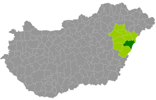
The 5th constituency of Hajdú-Bihar County is one of the single member constituencies of the National Assembly, the national legislature of Hungary. The constituency standard abbreviation: Hajdú-Bihar 05. OEVK.