Hajdúszoboszló

Last updated • 2 min readFrom Wikipedia, The Free Encyclopedia
Hajdúszoboszló
Flag Hungary Town Hajduszoboszlo.svg
Coa Hungary Town Hajduszoboszlo.svg
Nickname(s): 
"The sunniest city in Hungary" and "Mecca for rheumatism"
Hungary location map.svg
Red pog.svg
Hajdúszoboszló
Coordinates: 47°26′37.1″N21°23′22.28″E / 47.443639°N 21.3895222°E / 47.443639; 21.3895222
Country Flag of Hungary.svg  Hungary
County Hajdú-Bihar
District Hajdúszoboszló
Government
  Mayor Gyula Czeglédi
Area
  Total
238.7 km2 (92.2 sq mi)
Population
 (2017)
  Total
23,781 [1]
Time zone UTC1 (CET)
  Summer (DST) UTC+2 (CEST)
Postal code
4200
Area code (+36) 52
Website hajduszoboszlo.hu

Hajdúszoboszló (Hungarian pronunciation: [ˈhɒjduːsobosloː] ) is a town in Hajdú-Bihar county, Hungary, 19 kilometres (12 miles) southwest of county seat Debrecen. It is the third largest town in Hajdú-Bihar county.

Contents

Etymology

The name comes from a Slavic personal name Soběslav (see e.g. Soběslav, Soběslavice, Sebeslavce). [2]

Location

The town is located in the northeastern part of the Great Hungarian Plain. Three regions meet near the town: the Hajdúhát ridge to the north-north-east, the Hortobágy National Park (Puszta) to the north-north-west, and the Great Sárrét and Berettyó region to the south. Szoboszló lies at an altitude of scarcely 100 to 110 metres (328–361  ft ) above sea level and slopes slightly towards Hortobágy.

This is a landscape "where earth and sky meet", but not a monotonous plain, even for travellers accustomed to romantic mountains, since here and there the landscape is enlivened by the backwaters of the Tisza River with patches of reed, thousands of wild fowl, and inviting groves. The surroundings are the renowned puszta, the "glorious plain".

History

From historical data and archaeological finds, this part of the Great Plain was inhabited as far back as the Great Migrations. Because of the natural resources and the convergence of trade routes, Huns, Vandals, Gepids, Goths, and Avars frequently alternated with one another in this area. Early in the reign of the Árpád Dynasty, the area was inhabited by populous communities. The first written mention of Szoboszló dates back to 1075, when King Géza I donated half of Szoboszló's royal duty taxes to the new abbacy to be established at Garamszentbenedek.

With an ornate deed of gift dated 2 September 1606, István Bocskai, Prince of Transylvania, provided smallholdings for 700 Hajdú (Heyduck) cavalrymen at the site of Szoboszló, which had been destroyed by the Crimean Tartars. Henceforth the prefix Hajdú was attached to the settlement's previous Slavonic name, though the compound form - Hajdúszoboszló - only became widespread in the 19th century. The town led the customary, toilsome life of the small agricultural, stock-breeding towns of Hajdú County until well into the 20th century.

An upswing began on 26 October 1925 with the discovery of the thermal spring in the course of drilling for oil and gas. The medicinal water, tinged with natural iodine, led to the town's development into a resort spa, while agriculture retained its significant role even after the discovery of the gas field.

Population

Aerial photo of the strand (aquapark) Hajduszoboszlolegi1.jpg
Aerial photo of the strand (aquapark)

Spa complex

The water park includes water slides, an olympic-sized swimming pool, and a wave pool, while the spa features graded thermal pools, including a tepidarium and jacuzzi-type hot baths.

Official website: http://hajduszoboszlo.hu/en/

Twin towns – sister cities

Hajdúszoboszló is twinned with: [4]

47°26′N21°23′E / 47.433°N 21.383°E / 47.433; 21.383

Related Research Articles

<span class="mw-page-title-main">Geography of Hungary</span>

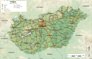
Hungary is a landlocked country in southeastern Central Europe, bordering the Balkans. Situated in the Pannonian Basin, it has a land area of 93,030 square km, measuring about 250 km from north to south and 524 km from east to west. It has 2,106 km of boundaries, shared with Slovakia to the north, Ukraine to the northeast, Romania to the east and southeast, Serbia to the south, Croatia to the south and southwest, Slovenia to the west and southwest, and Austria to the west.

<span class="mw-page-title-main">Debrecen</span> Second-largest city in Hungary

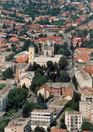
Debrecen is Hungary's second-largest city, after Budapest, the regional centre of the Northern Great Plain region and the seat of Hajdú-Bihar County. A city with county rights, it was the largest Hungarian city in the 18th century and it is one of the Hungarian people's most important cultural centres. Debrecen was also the capital city of Hungary during the revolution in 1848–1849. During the revolution, the dethronement of the Habsburg dynasty was declared in the Reformed Great Church. The city also served as the capital of Hungary by the end of World War II in 1944–1945. It is home to the University of Debrecen.

<span class="mw-page-title-main">Berettyóújfalu</span> Town in Hajdú-Bihar, Hungary

Berettyóújfalu is a town in Hajdú-Bihar county, in center of the Northern Great Plain region of eastern Hungary, near the border with Romania. It is strategically located, being 35 km south of Debrecen, the second largest city in Hungary, and 40 km west of Oradea, the tenth largest city in Romania. Berettyóújfalu is named after the river Berettyó.

<span class="mw-page-title-main">Hajdú–Bihar County</span> County of Hungary

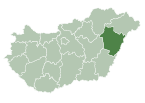
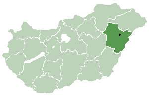
Hajdú–Bihar is an administrative county in eastern Hungary, on the border with Romania. It shares borders with the Hungarian counties Szabolcs-Szatmár-Bereg, Borsod–Abaúj–Zemplén, Jász–Nagykun–Szolnok and Békés. The capital of Hajdú-Bihar county is Debrecen. Together with Bihor County in Romania it constitutes the Biharia Euroregion.

<span class="mw-page-title-main">Puszta</span> Temperate grassland biome in Hungary

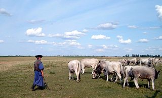
The Hungarian puszta is a temperate grassland biome of the Great Hungarian Plain. It is an exclave of the Pannonian Steppe, and lies mainly around the River Tisza in the eastern part of Hungary, as well as in the western part of the country and in the Burgenland of Austria.

<span class="mw-page-title-main">Békés County</span> County of Hungary

Békés is an administrative division in south-eastern Hungary, on the border with Romania. It shares borders with the Hungarian counties Csongrád, Jász-Nagykun-Szolnok, and Hajdú-Bihar. The capital of Békés county is Békéscsaba. The county is also part of the Danube-Kris-Mures-Tisa euroregion.

<span class="mw-page-title-main">Hajdúság</span>

Hajdúság is a historical and geographical region in Hungary, located in the Great Hungarian Plain around Debrecen. It consists of six hajdú towns, named Hajdúböszörmény, Hajdúdorog, Hajdúnánás, Hajdúhadház, Hajdúszoboszló and Vámospércs.

<span class="mw-page-title-main">Great Plain and North</span> Region in Hungary

Great Plain and North is a statistical region of Hungary. It comprises the NUTS 2 regions of Northern Hungary, Northern Great Plain, and Southern Great Plain.

<span class="mw-page-title-main">Püspökladány</span> Town in Hajdú-Bihar, Hungary

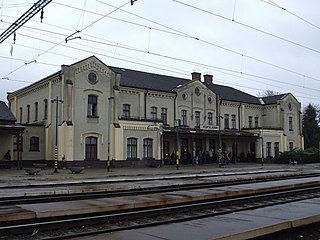
Püspökladány is the sixth largest town of Hajdú-Bihar county in North Eastern Hungary with a population of approximately 16,000 people. It is located southwest of Debrecen at the juncture of three regions: Sárrét, Hortobágy and Nagykunság. It is an important transportation hub at the junction of national highway 4 from Budapest to Záhony, and national highway No. 42 from Romania to Biharkeresztes. The town is served by four different rail lines.

<span class="mw-page-title-main">Hajdúdorog</span> Town in Hajdú-Bihar, Hungary

Hajdúdorog is a town in Hajdú-Bihar county, in the Northern Great Plain region of eastern Hungary. Hajdúdorog had a population of 8,797 in 2014, with a population density of 8,997 people per km2. The city is 130 m above sea level and the district area is 100.65 km2.

<span class="mw-page-title-main">Hajdúnánás</span> Town in Hajdú-Bihar, Hungary

Hajdúnánás is a town in Hajdú-Bihar County, in the Northern Great Plain region of eastern Hungary.

Zsáka is a large village in Hajdú-Bihar county, in the Northern Great Plain region of eastern Hungary.

<span class="mw-page-title-main">Létavértes</span> Town in Hajdú-Bihar, Hungary

Létavértes is a town in Hajdú-Bihar county, in the Northern Great Plain region of eastern Hungary.

<span class="mw-page-title-main">Görbeháza</span> Place in Hajdú-Bihar, Hungary

Görbeháza is a village in Hajdú-Bihar county, in the Northern Great Plain region of eastern Hungary.

<span class="mw-page-title-main">Hortobágy</span> Place in Northern Great Plain, Hungary

Hortobágy is a village in Hajdú-Bihar County in eastern Hungary. It lies on the banks of the Hortobágy river, which is crossed at Hortobágy by the Nine-arched Bridge, one of the principal man-made monuments of the Hortobágy National Park. The park consists mainly of the remaining areas of Hungarian puszta.

<span class="mw-page-title-main">Debrecen District</span> Districts of Hungary in Hajdú-Bihar

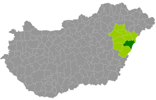
Debrecen is a district in central part of Hajdú-Bihar County. Debrecen is also the name of the town where the district seat is found. The district is located in the Northern Great Plain Statistical Region.

<span class="mw-page-title-main">Balmazújváros District</span> Districts of Hungary in Hajdú-Bihar

Balmazújváros is a district in north-western part of Hajdú-Bihar County. Balmazújváros is also the name of the town where the district seat is found. The district is located in the Northern Great Plain Statistical Region. This district is a part of Hajdúság historical and geographical region.

<span class="mw-page-title-main">Hajdúszoboszló District</span> Districts of Hungary in Hajdú-Bihar

Hajdúszoboszló is a district in western part of Hajdú-Bihar County. Hajdúszoboszló is also the name of the town where the district seat is found. The district is located in the Northern Great Plain Statistical Region. This district is a part of Hajdúság historical and geographical region.

<span class="mw-page-title-main">Derecske District</span> Districts of Hungary in Hajdú-Bihar

Derecske is a district in central-eastern part of Hajdú-Bihar County. Derecske is also the name of the town where the district seat is found. The district is located in the Northern Great Plain Statistical Region.

References

Notes
  1. Hajdúszoboszló, KSH
  2. Stanislav, Ján (2004). Slovenský juh v stredoveku II (in Slovak). Slovenské literárne centrum. p. 417. ISBN   80-88878-89-6.
  3. "Hajdúszoboszló népessége, lakossága, területe".
  4. "Testvérvárosaink". hajduszoboszlo.hu (in Hungarian). Hajdúszoboszló. 15 February 2018. Retrieved 2021-04-07.