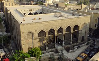
Qasaba of Radwan Bey

Last updated
Qasaba of Radwan Bey
Native name
Arabic: قَـصَـبَـة رضوان بيه
Street of the Tentmakers, Souq al-Khayamiya
Cairo, mercato delle tende, 02.JPG
The Qasaba or covered market street
Typehistoric souq (covered market)
Location Cairo, Egypt
Coordinates 30°02′31.29″N31°15′27.1836″E / 30.0420250°N 31.257551000°E / 30.0420250; 31.257551000
FounderRadwan Bey
Builtc.1650
Original useShoemakers' market; commercial and charitable complex attached to aristocratic residence
Current use khayamiya (decorative textile) market
Egypt adm location map.svg
Red pog.svg
Location of Qasaba of Radwan Bey in Egypt

The Qasaba of Radwan Bey is a souq and covered market in Cairo, Egypt, located directly south of the Bab Zuweila gate and just outside the historic walled city. Its dates to around 1650 CE, when its founder, Radwan Bey, initiated a series of constructions in this area. It is the only existing example of a historic covered market street in Cairo. [1] Today it is also known as the Street of the Tentmakers or al-Khayamiya, the last major market dedicated to the sale of decorative textiles known as khayamiya .

Contents

Historical background

Patron and context

The market was built by Radwan (or Ridwan) Bey, a Mamluk Bey who dominated the politics of Egypt from 1631 to 1656 (CE). [2] His influence was partly based on the fact that he occupied for a remarkable 25 years the important post of amir al-hajj, the official in charge of organizing the pilgrimage to Mecca (hajj) which departed from Cairo every year. [1]

The market was built in the context of one of several urbanization enterprises carried out by powerful and wealthy officials in the 17th century which sought to develop the southern districts of Cairo between Bab Zuweila and the Citadel. Radwan Bey reorganized and rebuilt the district which had been formerly occupied by tanneries just outside Bab Zuweila. [3] The area had also been occupied by various residences and a few older religious buildings (such as the Mosque of Salih Tala'i and the Mosque of al-Kurdi, both still standing today).

The location of Radwan Bey's complex followed a clear logic in the economic geography of Cairo at the time. Since Fatimid times (10th century) the main commercial axis of Cairo was a street with a north–south orientation running between Bab Zuweila and Bab al-Futuh (the southern and northern gates of the Fatimid city, respectively). This street is known today as al-Mu'izz street but was also referred to as the qasaba ("avenue"). It had been the center of the city's commercial and economic activity since its Fatimid foundation. [4] (The well-known Khan al-Khalili, for example, is located along this axis.) South of Bab Zuweila, beyond the old Fatimid walls, the road continued south to Saliba Street and ultimately all the way to the Southern Cemetery of Cairo. Radwan Bey's construction thus helped to extend the main commercial axis of Cairo further south beyond Bab Zuweila as the city developed in this direction. [3]

Construction

Radwan Bey carried out a series of constructions in the area from at least 1629 to 1647 (as recorded in waqf documents). [1] [5] :196 Radwan established not only a new covered market but also a wikala (caravanserai), a rab' (rental apartment building), one or two zawiyas, a sabil (public water dispensary) and maktab (primary school), two minor mosques, and his own palace. [1] [5] :197 These various elements were more or less connected together and formed one large complex. [5] Caroline Williams dates the covered market to around the year 1650. [1] Parts of the street were widened and straightened along areas of new construction in Radwan Bey's projects. [3] [5] :209 Another element of the complex, the combined sabil and maktab, is dated to 1650 by the waqf documents and was most likely the last part of the complex to be built. [5] :209

Radwan Bay's palace was adjacent to the market and located just south of it, on the west side of the street. Only a small part of it remains today. [1] The site of his mansion had also been the site of other palaces as far back as the 13th century. [1] Directly north of the palace was located the wikala or caravanserai, also adjacent to the market. [3]

According to historian André Raymond, the market was originally built to house shoemakers in Radwan Bey's time. [1] The association of the market with the guild of tentmakers (khayyāmīn) is also documented from at least the 17th century. [5] :201

Present day

Over time, many of the elements of Radwan Bey's original development have disappeared or been built over, but the covered market remains relatively well-preserved and one of the most impressive remaining examples of purpose-built commercial/economic buildings in historic Cairo. [3] Only fragments of Radwan's mansion also still remain. [1] Restoration works were carried out on the market between 2002 and 2004 to restore the market's street facades. [6]

Today, the area is popularly known as al-Khayamiya or Suq al-Khayyāmiya, a market dedicated to the sale of khayamiya textiles, a type of traditional decorative appliqué textile used for tentmaking. [1] [5] :201

Architecture

The whole complex built by Radwan Bey extended around 150 meters along the main street. Some 50 meters or more of this street is covered by a wooden roof pierced with skylights. On both sides of the street, the ground level of the building is built in stone and features large bays or spaces for shops facing the street, while the upper level is built of wood and is supported by thick wooden corbels at regular intervals that allow it to project further over the street. These upper floors provided apartments where the artisans or others could live (a type of building referred to in documents as a rab'). [3]

Parts of Radwan's mansion also still remain at the southern end of the covered market, on the western side of the street. Here, a stone portal leads to a courtyard that once was part of the palace. Here one can see some mashrabiya (wooden screen) windows and, on the southern side, a maq'ad or second-story loggia that once overlooked the house's courtyard. Some decorative marble along the walls of the maq'ad still remain. [1]

Related Research Articles

<span class="mw-page-title-main">Islamic Cairo</span> Part of central Cairo around the old walled city

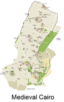
Islamic Cairo, or Medieval Cairo, officially Historic Cairo, refers mostly to the areas of Cairo, Egypt, that were built from the Muslim conquest in 641 CE until the city's modern expansion in the 19th century during Khedive Ismail's rule, namely: the central parts within the old walled city, the historic cemeteries, the area around the Citadel of Cairo, parts of Bulaq, and Old Cairo which dates back to Roman times and includes major Coptic Christian monuments.

<span class="mw-page-title-main">Al-Salih Tala'i Mosque</span> Mosque in Cairo, Egypt

The Mosque of al-Salih Tala'i is a late Fatimid-era mosque built by the vizier Tala'i ibn Ruzzik in 1160. It is located south of Bab Zuweila, just outside the southern entrance to the old walled city of Cairo.

<span class="mw-page-title-main">Khan el-Khalili</span> Major souk in Cairo

Khan el-Khalili is a famous bazaar and souq in the historic center of Cairo, Egypt. Established as a center of trade in the Mamluk era and named for one of its several historic caravanserais, the bazaar district has since become one of Cairo's main attractions for tourists and Egyptians alike. It is also home to many Egyptian artisans and workshops involved in the production of traditional crafts and souvenirs. The name Khan el-Khalili historically referred to a single building in the area; today it refers to the entire shopping district.

<span class="mw-page-title-main">Al-Hussein Mosque</span> Mosque in Cairo, Egypt

The al-Hussein Mosque or al-Husayn Mosque, also known as the Mosque of al-Imam al-Husayn and the Mosque of Sayyidna al-Husayn, is a mosque and mausoleum of Husayn ibn Ali, originally built in 1154, and then later reconstructed in 1874. The mosque is located in Cairo, Egypt, near the Khan El-Khalili bazaar, near-by the famous Al Azhar Mosque, in an area known as Al-Hussain. It is considered to be one of the holiest Islamic sites in Egypt. Some Shia Muslims believe that Husayn's head is buried on the grounds of the mosque where a mausoleum is located today and considered to be what is left of the Fatimid architecture in the building.

<span class="mw-page-title-main">Bab al-Nasr (Cairo)</span> Historic city gate in Cairo, Egypt

Bab al-Nasr, is one of three remaining gates in the historic city wall of Cairo, the capital of Egypt. The gate's construction is dated to 1087 and was ordered by Badr al-Jamali, a Fatimid vizier. It is located at the northern end of Shari'a al-Gamaliya in the old city of Cairo and slightly east of another contemporary gate, Bab al-Futuh.

<span class="mw-page-title-main">Sabil-Kuttab of Abd al-Rahman Katkhuda</span> Sabil fountain, kuttab elementary school, residential wing in Cairo, Egypt

Sabil-Kuttab of Abd al-Rahman Katkhuda is a historic monument in the historic district of Cairo, Egypt. It comprises a public fountain or sabil, an elementary Quran school or kuttab, and an adjacent residential wing. A prime example of Egyptian architecture of its time, it was commissioned in 1744 by Abd al-Rahman Katkhuda, a local official who was a prominent patron of architecture.

<span class="mw-page-title-main">Al-Mu'izz Street</span> Street in Cairo Governorate, Egypt

Al-Muizz li-Din Allah al-Fatimi Street, or al-Muizz Street for short, is a major north-to-south street in the walled city of historic Cairo, Egypt. It is one of Cairo's oldest streets as it dates back to the foundation of the city by the Fatimid dynasty in the 10th century, under their fourth caliph, Al-Mu'izz li-Din Allah . Historically, it was the most important artery of the city and was often referred to as the Qasaba. It constituted the main axis of the city's economic zones where its souqs (markets) were concentrated. The street's prestige also attracted the construction of many monumental religious and charitable buildings commissioned by Egypt's rulers and elites, making it a dense repository of historic Islamic architecture in Cairo. This is especially evident in the Bayn al-Qasrayn area, which is lined with some of the most important monuments of Islamic Cairo.

<span class="mw-page-title-main">Bayn al-Qasrayn</span> District and plaza in old Cairo

Bayn al-Qasrayn is an area located along al-Mu'izz Street in the center of medieval Islamic Cairo, within present day Cairo, Egypt. It corresponds to what was formerly a plaza between two palace complexes constructed in the 10th century by the Fatimids, as part of their palace-city named al-Qahirah. This later became the site of many monumental buildings constructed during the Ayyubid, Mamluk, and Ottoman periods, up to the 19th century. Many of these historical monuments are still standing today.

<span class="mw-page-title-main">Aqmar Mosque</span> Mosque in Cairo, Egypt

The Aqmar Mosque, was built in Cairo, Egypt, as a neighborhood mosque by the Fatimid vizier al-Ma'mun al-Bata'ihi in 1125-6 CE. The mosque is situated on what was once the main avenue and ceremonial heart of Cairo, known today as al-Mu'izz Street, in the immediate neighborhood of the former Fatimid caliphal palaces. The mosque is an important monument of Fatimid architecture and of historic Cairo due to the exceptional decoration of its exterior façade and the innovative design of its floor plan.

<span class="mw-page-title-main">Sultan al-Ghuri Complex</span>

The Sultan al-Ghuri Complex or Funerary complex of Sultan al-Ghuri, also known as al-Ghuriya, is a monumental Islamic religious and funerary complex built by Sultan Qansuh al-Ghuri between 1503 and 1505 CE. The complex consists of two major buildings facing each other on al-Mu'izz li-Din Allah street, in the Fahhamin Quarter, in the middle of the historic part of Cairo, Egypt. The eastern side of the complex includes the Sultan's mausoleum, a khanqah, a sabil, and a kuttab, while the western side of the complex is a mosque and madrasa. Today the mosque-madrasa is still open as a mosque while the khanqah-mausoleum is open to visitors as a historic site.

<span class="mw-page-title-main">Khayamiya</span> Egyptian decorative art appliqué textile

Khayamiya is a decorative Egyptian art appliqué textile, that dates back to as far as Ancient Egypt. They are now primarily made in Cairo, Egypt, along what is known as the Street of the Tentmakers centered in the Qasaba of Radwan Bey, a historic covered market built in the 17th century. The street is located immediately south of bawabet el metwali, and is located along the historic economic axis of Cairo, in a section within Muizz street.

<span class="mw-page-title-main">Fatimid architecture</span> Building style of the 10th to 12th centuries

The Fatimid architecture that developed in the Fatimid Caliphate (909–1167 CE) of North Africa combined elements of eastern and western architecture, drawing on Abbasid architecture, Byzantine, Ancient Egyptian, Coptic architecture and North African traditions; it bridged early Islamic styles and the medieval architecture of the Mamluks of Egypt, introducing many innovations.

<span class="mw-page-title-main">Mamluk architecture</span> Building style of 13th–16th century in the Middle East

Mamluk architecture was the architectural style that developed under the Mamluk Sultanate (1250–1517), which ruled over Egypt, the Levant, and the Hijaz from their capital, Cairo. Despite their often tumultuous internal politics, the Mamluk sultans were prolific patrons of architecture and contributed enormously to the fabric of historic Cairo. The Mamluk period, particularly in the 14th century, oversaw the peak of Cairo's power and prosperity. Their architecture also appears in cities such as Damascus, Jerusalem, Aleppo, Tripoli, and Medina.

<span class="mw-page-title-main">Wikala and Sabil-Kuttab of Sultan Qaytbay</span>

The Wikala and Sabil-Kuttab of Sultan Qaytbay is a complex of monuments built by the Mamluk sultan Al-Ashraf Abu Al-Nasr Qaitbay in 1477 CE in Islamic Cairo, the historic medieval district of Cairo, Egypt. The complex consists of an urban caravanserai, a water dispensary (sabil), a water trough (hod), and a school (kuttab). It is located just south of Al-Azhar Mosque.

<span class="mw-page-title-main">Mahmud al-Kurdi Mosque</span> Mosque in Cairo, Egypt

Mahmud al-Kurdi Mosque or Jamal al-Din Mahmud al-Istadar Mosque is a historic mosque in Cairo, Egypt. It was founded by an amir called Mahmud al-Kurdi who was the ustadar or majordomo of the Mamluk Sultan Barquq. It is located just south of the Qasaba of Radwan Bey which branches out from the Ahmad Maher Street, in Historic Cairo, in the district of al-Darb al-Ahmar.

<span class="mw-page-title-main">Outline of Cairo</span> Overview of and topical guide to Cairo

The following outline is provided as an overview of and topical guide to Cairo:

<span class="mw-page-title-main">Ottoman architecture in Egypt</span> Overview of Ottoman architecture in Egypt

Ottoman architecture in Egypt, during the period after the Ottoman conquest in 1517, continued the traditions of earlier Mamluk architecture but was influenced by the architecture of the Ottoman Empire. Important new features introduced into local architecture included the pencil-style Ottoman minaret, central-domed mosques, new tile decoration and other characteristics of Ottoman architecture. Architectural patronage was reduced in scale compared to previous periods, as Egypt became an Ottoman province instead of the center of an empire. One of the most common types of building erected in Cairo during this period is the sabil-kuttab.

<span class="mw-page-title-main">Al-Darb al-Ahmar</span> District of Cairo, Egypt

Al-Darb al-Ahmar is a centuries old historic neighbourhood in the UNESCO World Heritage Site of Historic Cairo, Egypt. Located south of the old walled city of Cairo, originally built by the Fatimids in the 10th century, it began to urbanize largely during the 14th century in the Mamluk period.

<span class="mw-page-title-main">Fatimid Great Palaces</span> Palace complex built during the Fatimid Caliphate

The Great Palaces of the Fatimid Caliphs were a vast and lavish palace complex built in the late 10th century in Cairo, Egypt, to house the Fatimid caliphs, their households, and the administration of their state. There were two main palace complexes, the Eastern and the Western Palace. They were located in the center of the walled city of Cairo around the area still known today as Bayn al-Qasrayn.

References

  1. 1 2 3 4 5 6 7 8 9 10 11 Williams, Caroline (2008). Islamic Monuments in Cairo: The Practical Guide (6th edition). Cairo: American University in Cairo Press. pp. 106–107. ISBN   9789774162053.
  2. Raymond, André (1993). Le Caire. Fayard. pp. 199–200. ISBN   2213029830.
  3. 1 2 3 4 5 6 Raymond, André (1993). Le Caire. Fayard. pp. 221, 237. ISBN   2213029830. OCLC   410735582.
  4. Raymond, André (1993). Le Caire. Fayard. ISBN   2213029830.
  5. 1 2 3 4 5 6 7 Warner, Nicholas (2007). "Commerce and spirituality: The urbanism of Ridwan Bey". In Bennison, Amira K.; Gascoigne, Alison L. (eds.). Cities in the Pre-Modern Islamic World: The Urban Impact of Religion, State and Society. Routledge. pp. 196–224. ISBN   978-1-134-09650-3.
  6. "Qasaba Radwan Bey". ArchNet. Retrieved January 2, 2018.

Further reading