Cairo is the capital of Egypt and the city-state Cairo Governorate, and is the country's largest city, home to 10 million people. It is also part of the largest urban agglomeration in Africa, the Arab world and the Middle East: The Greater Cairo metropolitan area is the 11th-largest in the world by population with a population of over 22.1 million.

The Gates of Cairo were gates at portals in the city walls of medieval Islamic Cairo, within the present day city of Cairo, Egypt.

The al-Hakim Mosque, nicknamed al-Anwar, is a historic mosque in Cairo, Egypt. It is named after Al-Hakim bi-Amr Allah (985–1021), the sixth Fatimid caliph and 16th Ismaili Imam. Construction of the mosque was originally started by Caliph al-'Aziz, the son of al-Mu'izz and the father of al Hakim, in 990 AD. It was completed in 1013 by al-Hakim, which is why it is named after him.

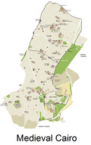
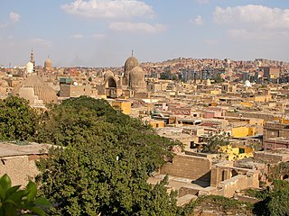
Islamic Cairo, or Medieval Cairo, officially Historic Cairo, refers mostly to the areas of Cairo, Egypt, that were built from the Muslim conquest in 641 CE until the city's modern expansion in the 19th century during Khedive Ismail's rule, namely: the central parts within the old walled city, the historic cemeteries, the area around the Citadel of Cairo, parts of Bulaq, and Old Cairo which dates back to Roman times and includes major Coptic Christian monuments.

The Citadel of Cairo or Citadel of Saladin is a medieval Islamic-era fortification in Cairo, Egypt, built by Salah ad-Din (Saladin) and further developed by subsequent Egyptian rulers. It was the seat of government in Egypt and the residence of its rulers for nearly 700 years from the 13th century until the construction of Abdeen Palace in the 19th century. Its location on a promontory of the Mokattam hills near the center of Cairo commands a strategic position overlooking the city and dominating its skyline. When it was constructed it was among the most impressive and ambitious military fortification projects of its time. It is now a preserved historic site, including mosques and museums.

Al-Azhar Park is a public park located in qism al-Darb al-Ahmar, in Historic Cairo, Egypt.

Khan el-Khalili is a famous bazaar and souq in the historic center of Cairo, Egypt. Established as a center of trade in the Mamluk era and named for one of its several historic caravanserais, the bazaar district has since become one of Cairo's main attractions for tourists and Egyptians alike. It is also home to many Egyptian artisans and workshops involved in the production of traditional crafts and souvenirs. The name Khan el-Khalili historically referred to a single building in the area; today it refers to the entire shopping district.

The al-Hussein Mosque or al-Husayn Mosque, also known as the Mosque of al-Imam al-Husayn and the Mosque of Sayyidna al-Husayn, is a mosque and mausoleum of Husayn ibn Ali, originally built in 1154, and then later reconstructed in 1874. The mosque is located in Cairo, Egypt, near the Khan El-Khalili bazaar, near-by the famous Al Azhar Mosque, in an area known as Al-Hussain. It is considered to be one of the holiest Islamic sites in Egypt. Some Shia Muslims believe that Husayn's head is buried on the grounds of the mosque where a mausoleum is located today and considered to be what is left of the Fatimid architecture in the building.
The City of the Dead, or Cairo Necropolis, also referred to as theQarafa, is a series of vast Islamic-era necropolises and cemeteries in Cairo, Egypt. They extend to the north and to the south of the Cairo Citadel, below the Mokattam Hills and outside the historic city walls, covering an area roughly 4 miles (6.4 km) long. They are included in the UNESCO World Heritage Site of "Historic Cairo".

Bab al-Nasr, is one of three remaining gates in the historic city wall of Cairo, the capital of Egypt. The gate's construction is dated to 1087 and was ordered by Badr al-Jamali, a Fatimid vizier. It is located at the northern end of Shari'a al-Gamaliya in the old city of Cairo and slightly east of another contemporary gate, Bab al-Futuh.

Al-Muizz li-Din Allah al-Fatimi Street, or al-Muizz Street for short, is a major north-to-south street in the walled city of historic Cairo, Egypt. It is one of Cairo's oldest streets as it dates back to the foundation of the city by the Fatimid dynasty in the 10th century, under their fourth caliph, Al-Mu'izz li-Din Allah . Historically, it was the most important artery of the city and was often referred to as the Qasaba. It constituted the main axis of the city's economic zones where its souqs (markets) were concentrated. The street's prestige also attracted the construction of many monumental religious and charitable buildings commissioned by Egypt's rulers and elites, making it a dense repository of historic Islamic architecture in Cairo. This is especially evident in the Bayn al-Qasrayn area, which is lined with some of the most important monuments of Islamic Cairo.

Bayn al-Qasrayn is an area located along al-Mu'izz Street in the center of medieval Islamic Cairo, within present day Cairo, Egypt. It corresponds to what was formerly a plaza between two palace complexes constructed in the 10th century by the Fatimids, as part of their palace-city named al-Qahirah. This later became the site of many monumental buildings constructed during the Ayyubid, Mamluk, and Ottoman periods, up to the 19th century. Many of these historical monuments are still standing today.
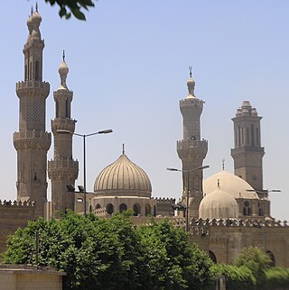
Al-Azhar Mosque, known in Egypt simply as al-Azhar, is a mosque in Cairo, Egypt in the historic Islamic core of the city. Commissioned as the new capital of the Fatimid Caliphate in 970, it was the first mosque established in a city that eventually earned the nickname "the City of a Thousand Minarets". Its name is usually thought to derive from az-Zahrāʾ, a title given to Fatimah, the daughter of Muhammad.
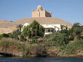
The Mausoleum of Aga Khan is the mausoleum of Aga Khan III, Sir Sultan Muhammed Shah, who died in 1957. The mausoleum is located at Aswan along the Nile of Egypt, since Egypt was formerly the centre of power of the Fatimids, an Ismaili Shia dynasty.

The Fatimid architecture that developed in the Fatimid Caliphate (909–1167 CE) of North Africa combined elements of eastern and western architecture, drawing on Abbasid architecture, Byzantine, Ancient Egyptian, Coptic architecture and North African traditions; it bridged early Islamic styles and the medieval architecture of the Mamluks of Egypt, introducing many innovations.

The Wikala of Sultan Qaytbay or Wakala of Sultan Qaytbay is an urban caravanserai and rab built by Sultan al-Ashraf Abu al-Nasr Qaitbay in 1481 CE in Islamic Cairo, the historic medieval district of Cairo, Egypt.

The following outline is provided as an overview of and topical guide to Cairo:

Al-Darb al-Ahmar is a centuries old historic neighbourhood in the UNESCO World Heritage Site of Historic Cairo, Egypt. Located south of the old walled city of Cairo, originally built by the Fatimids in the 10th century, it began to urbanize largely during the 14th century in the Mamluk period.

The Great Palaces of the Fatimid Caliphs were a vast and lavish palace complex built in the late 10th century in Cairo, Egypt, to house the Fatimid caliphs, their households, and the administration of their state. There were two main palace complexes, the Eastern and the Western Palace. They were located in the center of the walled city of Cairo around the area still known today as Bayn al-Qasrayn.

The Mosque of Aslam al-Silahdar is a 14th-century mosque and mausoleum in the Al-Darb al-Ahmar neighbourhood of Cairo, Egypt.