
Socorro is a city in Socorro County in the U.S. state of New Mexico. It is in the Rio Grande Valley at an elevation of 4,579 feet (1,396 m). In 2010 the population was 9,051. It is the county seat of Socorro County. Socorro is located 74 miles (119 km) south of Albuquerque and 146 miles (235 km) north of Las Cruces.
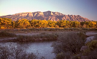
The Sandia Mountains are a mountain range located in Bernalillo and Sandoval counties, immediately to the east of the city of Albuquerque in New Mexico in the southwestern United States. The mountains are just due south of the southern terminus of the Rocky Mountains, and are part of the Sandia–Manzano Mountains. This is largely within the Cibola National Forest and protected as the Sandia Mountain Wilderness. The highest point is Sandia Crest, 10,678 feet (3,255 m).

Zuzax is an unincorporated community in Bernalillo County, New Mexico, United States. It lies on New Mexico State Highway 333, former U.S. Highway 66, about eleven miles (18 km) east of Albuquerque. It is now largely an area of subdivisions. An exit for Zuzax exists on nearby Interstate 40. It was known in the 1950s for its tourist store and short chair lift ride which ascended a small hill behind the store.
The Piro pueblo of Senecú was the southernmost occupied pueblo in New Mexico prior to the Pueblo Revolt of 1680. It was located on the west bank of the Rio Grande within sight of the Piro pueblo of San Pasqual. Colonial Spanish documents consistently place the pueblo opposite of Black Mesa, which is near San Marcial. Due to changes in the floodplain and the establishment of San Marcial, however, no surface remains of the pueblo survive in the area.

The Cimarron River, flowing entirely in New Mexico, was also known as La Flecha or Semarone. Its headwaters are Moreno, Sixmile, and Cieneguilla creeks in the Sangre de Cristo Mountains, which feed into Eagle Nest Dam. From the dam, it runs for 60 miles (97 km) to below the city of Springer, New Mexico in the Taylor Springs area, where it flows into the Canadian River, the southwesternmost major tributary flowing into the Mississippi River via the Arkansas River sub-basin.

Tijeras Canyon is a prominent canyon in the central part of the U.S. state of New Mexico. It separates the Sandia Mountains subrange to the north from the Manzano Mountains subrange to the south. These subranges are part of the larger Sandia–Manzano Mountains; Tijeras Canyon forms a pass through this range. Elevations along the bottom of the canyon range from 5,600 feet (1,700 m) to 7,000 feet (2,100 m) above sea level. The canyon drains to the west, into a large dry wash known as Tijeras Arroyo, which runs through Kirtland Air Force Base, passes just south of the Albuquerque International Airport, and then joins the Rio Grande. The arroyo heads at the historically important pass, and this pass and the entire canyon are traversed by Interstate 40, following the path of historic U.S. Route 66.
Golondrinas is an unincorporated community in Mora County, New Mexico, United States, on State Route 161 next to the Mora River, approximately 18 mi (29 km) south of the town of Mora. It is at an elevation of 6,833 ft (2,083 m).

Interstate 25 (I-25) in the US state of New Mexico follows the north–south corridor through Albuquerque and Santa Fe. It replaced U.S. Route 85 (US 85), which is no longer signed, but still exists in route logs sharing the I-25 alignment. I-25 starts in New Mexico at an interchange with I-10 in Las Cruces and extends roughly 460 miles (740 km) before reaching Colorado. I-25 passes through principally rural land through central New Mexico and passes through or near the cities of Las Cruces, Truth or Consequences, Socorro, Belen, Albuquerque, Santa Fe, Las Vegas, and Raton.
Carpenter Mesa is a mesa located at 352047N 1035215W in San Miguel County, New Mexico, northeast of Tucumcari.
Lingo is a populated place in Roosevelt County, New Mexico, United States, located at latitude 33.7884278 and longitude -103.1146674, at 3,986 feet of elevation. The original name given the settlement in 1916 was “Need”, but U.S. postal authorities said that was too much like “Weed” in Otero County, so in 1918 the name was changed to "Lingo".
Hondo is an unincorporated community in Lincoln County, New Mexico, United States. It is located about thirty-five miles downstream (east) from Ruidoso Downs, where the Rio Bonito and Rio Ruidoso rivers join together to form the Rio Hondo. It is located at the point where U.S. Route 70 is joined by U.S. Route 380, which conjoined route continues eastward. It has had a post office since 1900.

Road Forks is an unincorporated community in western Hidalgo County, New Mexico, United States, in the southwestern corner of the state. It is 6.2 miles (10 km) east of the Arizona border, due east of Stern's Mountain, and at the junction of Interstate 10 and NM Route 80. It is 15 miles (24 km) southwest of the city of Lordsburg and 3 miles (4.8 km) east of Steins. Road Forks had a post office from shortly after its founding in 1925 until 1955, when postal services were transferred to Lordsburg.
Bernardo is an unincorporated community in Socorro County, New Mexico, United States, at the northern junction of US 60 and Interstate 25. Bernardo was named, circa 1902, after a friend of John Becker, a leading merchant in nearby Belen. The main point of interest is the nearby Bernardo Wildlife Management Area, visited by large flocks of sandhill cranes and other birds.
Counselor is an unincorporated community in Sandoval County, New Mexico, United States. Counselor is located at the junction of U.S. Route 550 and New Mexico State Road 403. It is a chapter of the Navajo Nation. It is named after Jim Counselor, who traded in the area in the first decades of the 20th century.
Riverside is an unincorporated community in Grant County, New Mexico, United States. It lies on the left (east) bank of the Gila River and on both sides of U.S. Route 180 in southwestern New Mexico, 2.6 miles (4.2 km) by road south of Cliff.
Riverside is an unincorporated community in Lincoln County, New Mexico, in the southwestern United States. It is located along the Rio Hondo that flows east out of the Sacramento Mountains, the Sierra Blanca and the Capitan Mountains of south-central New Mexico. It is on combined routes U.S. 380 and U.S. 70, between the town of Lincoln and Roswell. The nearest community is Sunset about a mile upstream.
Riverside (Hendricks) is an unincorporated community in San Juan County, New Mexico, United States. It is on the right bank of the Animas River, approximately one mile south of the Colorado border on U.S. Route 550, at its intersection with county roads 2090 and 2093. The nearest settlement is Cedar Hill, 3.5 miles (5.6 km) to the south.
Palo Flechado Pass, also called Taos Pass and Old Taos Pass, is a mountain pass located in Taos County, New Mexico on the Enchanted Circle Scenic Byway.
Cambray is a locality in eastern Luna County, New Mexico at an elevation of 4,219 feet (1,286 m). It is located one mile west of the Doña Ana county line. Cambray was first a water stop on the Southern Pacific Railroad, then a stop along U.S. Route 70 and U.S. Route 80. When the highway was realigned in 1956, Cambray slowly fell into decline and became a ghost town.


