A Pure Michigan Byway is the designation for a segment of the State Trunkline Highway System in the US state of Michigan that is a "scenic, recreational, or historic route that is representative of Michigan's natural and cultural heritage." The designation was created with the name Michigan Heritage Route by the state legislature on June 22, 1993, and since then six historic, seven recreational and seven scenic byways have been designated by the Michigan Department of Transportation (MDOT), and another two have been proposed. These byways have been designated in both the Upper and Lower peninsulas of the state. The current name was adopted on December 30, 2014, and it references the Pure Michigan tourism marketing campaign.
U.S. Route 491 (US 491) is a north–south U.S. Highway serving the Four Corners region of the United States. It was created in 2003 as a renumbering of U.S. Route 666 (US 666). With the US 666 designation, the road was nicknamed the "Devil's Highway" because of the significance of the number 666 to many Christian denominations as the Number of the Beast. This Satanic connotation, combined with a high fatality rate along the New Mexico portion, convinced some people the highway was cursed. The problem was compounded by persistent sign theft. These factors led to two efforts to renumber the highway, first by officials in Arizona, then by those in New Mexico. There have been safety improvement projects in recent years, and fatality rates have subsequently decreased.

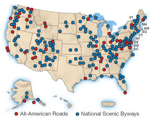
A National Scenic Byway is a road recognized by the United States Department of Transportation for one or more of six "intrinsic qualities": archeological, cultural, historic, natural, recreational, and scenic. The program was established by Congress in 1991 to preserve and protect the nation's scenic but often less-traveled roads and promote tourism and economic development. The National Scenic Byways Program (NSBP) is administered by the Federal Highway Administration (FHWA).

The historic U.S. Route 66 ran east–west across the central part of the state of New Mexico, along the path now taken by Interstate 40 (I-40). However, until 1937, it took a longer route via Los Lunas, Albuquerque, and Santa Fe, now roughly New Mexico State Road 6 (NM 6), I-25, and US 84. Large portions of the old road parallel to I-40 have been designated NM 117, NM 118, NM 122, NM 124, NM 333, three separate loops of I-40 Business, and state-maintained frontage roads.

The Trail of the Ancients is a National Scenic Byway located in the states of Colorado and Utah. The route highlights the archaeological and cultural history of southwestern Native American peoples, and traverses the widely diverse geological landscape of the Four Corners region of the Colorado Plateau. It was the first National Scenic Byway that was designated solely for its archaeological sites. The entire route is approximately 480 miles (772.5 km) long.
A scenic Byway in Ohio can be any interstate, national highway, state highway, County road, municipal street, or Township road in the State of Ohio as designated by the director of transportation.

Abo Canyon, also known as Abo Pass, is a mountain pass at the southern end of the Manzano Mountains of central New Mexico in the Southwest United States.
State Road 117 (NM 117) is a 62.06-mile-long (99.88 km) state road in north west New Mexico, entirely within Cibola County. The southern terminus is at NM 36 near Quemado, and the northern terminus is at NM 122 and Historic U.S. Route 66 in Grants. NM 117 runs through the El Malpais National Conservation Area.
The Enchanted Circle Scenic Byway is a New Mexico Scenic Byway and National Forest Scenic Byway located in Northern New Mexico. It begins and ends in Taos, New Mexico.

The Trail of the Ancients is a New Mexico Scenic Byway to prehistoric archaeological and geological sites of northwestern New Mexico. It provides insight into the lives of the Ancestral Puebloans and the Navajo, Ute, and Apache peoples. Geological features include canyons, volcanic rock features, and sandstone buttes. Several of the sites are scenic and wilderness areas with recreational opportunities.

Many roads and highways in the United States are labeled scenic byways for having exceptional scenic, historical, archaeological, natural, cultural, or recreational significance. These scenic routes are usually formally designated by national, state, or local agencies in recognition of these qualities, and many are also preserved or managed with special legislation and funding beyond what is required for ordinary road maintenance.

Geronimo Trail Scenic Byway is a US National Scenic Byway commemorating Chiricahua Apache warrior Geronimo. The road is also recognized by the New Mexico Department of Transportation as a scenic and historic byway. The town of Truth or Consequences, New Mexico lies at the center of this trail with a southern end at San Lorenzo, Grant County, New Mexico and a northern end at Beaverhead Ranger Station. The Federal Highway Administration gives the total length of this scenic road as 154.0 mi (247.8 km).
Minnesota Scenic Byways are a system of roads in the U.S. state of Minnesota which pass through areas of scenic, cultural, or recreational significance. There are currently 22 scenic byways in the system with a total length of 2,948 miles (4,744 km). Eight of these byways are also designated as National Scenic Byways, and the North Shore Scenic Drive is further designated as an All-American Road.


