| Region | Name | Image | Description | mi | km | References |
|---|
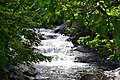
| Mountain | Waterfall Byway | 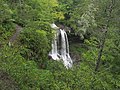 | Follows Harshaw Road (SR 1558), Brasstown Road (SR 1134), Old US 64 (SR 1100), Settawig Road (SR 1135) and US 64. Named for the 200 waterfalls that surround the route, it passes by notable sites including the Cullasaja Gorge, Highlands, Cashiers and Lake Toxaway. | 98.0 | 157.7 | [9] |
| Mountain | Nantahala Byway | 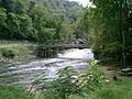 | The byway traverses between Marble and Whittier, along US 19/US 74/US 129. It is known for its scenic views of the Nantahala Gorge, The Great Smoky Mountain Railroad, and the whitewater rafting on the Nantahala River. | 43.0 | 69.2 | [9] |
| Mountain | Fontana Byway |  | The byway traverses along NC 28, from Deals Gap to the historic Cherokee town of Cowee. The byway points of interest includes the "Tail of the Dragon," Fontana Dam, Fontana Village, and the Needmore Tract. | 60.0 | 96.6 | [6] |
| Mountain | Whitewater Way |  |  NC 281 NC 281 | 9.0 | 14.5 | [9] |
| Mountain | Appalachian Medley |  |     US 25 / US 70 / NC 209 / NC 213 US 25 / US 70 / NC 209 / NC 213 | 45.0 | 72.4 | [9] |
| Mountain | Big Horse Creek Scenic Byway | |  NC 194 NC 194 | 18.0 | 29.0 | [10] |
| Mountain | French Broad Overview | | 
 US 25 Bus. / US 70 Bus. / NC 251 US 25 Bus. / US 70 Bus. / NC 251 | 17.0 | 27.4 | [9] |
| Mountain | Historic Flat Rock Scenic Byway | 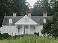 | The byway is located along NC 225, between Pinnacle Mountain Road (SR 1114) and Highland Lake Road (SR 1783), in the Flat Rock area. It is noted for its views of nearby Glassy and McAlpin mountains and access to the Carl Sandburg Home National Historic Site, the Flat Rock Playhouse and the Flat Rock Historic District. | 8.3 | 13.4 | [9] |
| Mountain | Drovers Road | |  US 74A US 74A | 16.5 | 26.6 | [9] |
| Mountain | Black Mountain Rag | | Follows US 64, from Edneyville to Lake Lure and NC 9, from Bat Cave to Black Mountain. The byway connects Chimney Rock State Park, Hickory Nut Gorge and Lake Lure. It is named after old fiddle tune, the Black Mountain Rag, for its full of twists, turns, ups and downs. | 31.0 | 49.9 | [9] |
| Mountain | Pacolet River Byway | 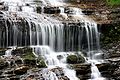 |  US 176 US 176 | 10.0 | 16.1 | [9] |
| Mountain | South Mountain Scenery | |  NC 226 NC 226 | 33.0 | 53.1 | [9] |
| Mountain | Mission Crossing |  | NC 194 | 17.0 | 27.4 | [9] |
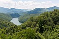
| Mountain | Mount Mitchell Scenic Drive |  | Starting at the I-26 interchange (exit 9), the byway follows US 19 in Madison County and US 19E in Yancey County. In Micaville, it switches onto NC 80 and goes through the Toe River valley. Connecting at the Blue Ridge Parkway, travelers continue south until reaching NC 128, where it makes its final ascent to the top of Mount Mitchell. The byway features mountain scenic vistas and local culture experience in Celo and Burnsville. | 52.0 | 83.7 | [9] [11] |
| Mountain | Little Parkway | 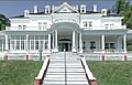 |  US 221 US 221 | 18.0 | 29.0 | [9] |
| Mountain | New River Valley Byway | 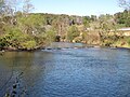 |  NC 88 / NC 194 NC 88 / NC 194 | 35.0 | 56.3 | [9] |
| Mountain | I-26 Scenic Highway | | The byway traverses between Tennessee state line and Exit 9 (US 19/US 23A), near Mars Hill, along I-26/US 23. The byway is known for its unspoiled views of the North Carolina Mountains. | 9.0 | 14.5 | [9] |
| Mountain | U.S. 421 Scenic Byway | | Follows US 221 and US 421 from the Blue Ridge Parkway, in Deep Gap, to the South Fork New River, near Boone. The byway features panoramic views of Snake Mountain and Elk Knob, as well as the forests, horse/cattle farms, and Fraser Fir Christmas Tree farms. | 8.0 | 12.9 | [9] |
| Mountain | Pisgah Loop Scenic Byway | 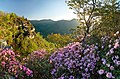 | The loop byway traverses along NC 181, NC 183, Old NC Highway 105 (SR 1238), NC 126 and Fish Hatchery Road (SR 1254/SR 1240). The byway is noted its history as the same route the Kirk's Raiders used to make a successful attack on Confederate Army Camp Vance, outside Morganton, during the Civil War. It is also noted for scenic views of the surrounding mountains and access to various trails along the route. Four-wheel drive is recommended for unpaved portions of the loop. | 47.0 | 75.6 | [9] |
| Mountain | Upper Yadkin Way |  | The byway traverses along NC 268 between US 321 and W.Kerr Scott Reservoir, in an area known as Happy Valley. Near Ferguson is the grave of Tom Dula, remembered in the folk song "Tom Dooley." | 25.0 | 40.2 | [9] |
| Mountain | Yadkin Valley Scenic Byway |  | The byway connects various vineyards and wineries in the area, starting from downtown Elkin and making a loop along US 21, Swan Creek Road, Old US 421, Rockford Road, Zephyr Road and Springs Road. | 65.0 | 104.6 | [9] |
| Piedmont | McAuley Road Scenic Byway | | Protected along lands controlled by the Catawba Lands Conservancy, the road provides one of the last vestiges of rural vistas of what once dominated Mecklenburg County till the mid-20th century. | 1.5 | 2.4 | [12] |
| Piedmont | Hanging Rock Scenic Byway | |   NC 66 / NC 89 NC 66 / NC 89 | 38.0 | 61.2 | [9] |
| Piedmont | Clayton Bypass Scenic Byway | | The byway is located along Interstate 42, between I-40 and US 70 Bus. It features rolling hills and open pastures peppered with woodlands. | 10.7 | 17.2 | [9] |
| Piedmont | Colonial Heritage Byway |  |
     US 70 Bus. / NC 57 / NC 62 / NC 86 / NC 150 / NC 751 US 70 Bus. / NC 57 / NC 62 / NC 86 / NC 150 / NC 751 | 92.0 | 148.1 | [9] |
| Piedmont | Football Road | 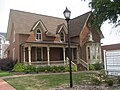 | | 37.0 | 59.5 | [9] |
| Piedmont | Crowders Mountain Drive | |  NC 161 NC 161 | 8.0 | 12.9 | [9] |
| Piedmont | Mill Bridge Scenic Byway |  | NC 150 | 14.0 | 22.5 | [9] |
| Piedmont | Uwharrie Scenic Road |  |  NC 49 NC 49 | 50.0 | 80.5 | [9] |
| Piedmont | Rolling Kansas Byway | | | 9.0 | 14.5 | [9] |
| Piedmont | Pee Dee Valley Drive | 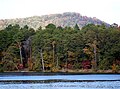 |    NC 24 / NC 27 / NC 73 NC 24 / NC 27 / NC 73 | 14.0 | 22.5 | [9] |
| Piedmont | Grassy Island Crossing |  |  NC 109 NC 109 | 26.0 | 41.8 | [9] |
| Piedmont | Sandhills Scenic Drive |  | NC 24 / NC 27 / NC 73 | 46.0 | 74.0 | [9] |
| Piedmont | Birkhead Wilderness Route | 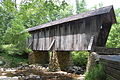 | | 14.0 | 22.5 | [9] |
| Piedmont | Flint Hill Ramble |  | | 5.0 | 8.0 | [9] |
| Piedmont | Indian Heritage Trail |  |  US 220 / NC 73 US 220 / NC 73 | 18.0 | 29.0 | [9] |
| Piedmont | Pottery Road |  | Located along NC 705, between Eagle Springs and Seagrove. The byway traverses through an area where seven families from Staffordshire, the pottery center of England, settled. Their descendants continue to make both traditional and modern pottery forms and nearly 80 potteries can be found in the vicinity of the byway. | 43.0 | 69.2 | [9] |
| Piedmont | Devil's Stompin' Ground Road | 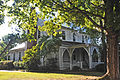 |  NC 902 NC 902 | 43.0 | 69.2 | [9] |
| Piedmont | North Durham Country Byway |  | | 27.0 | 43.5 | [9] |
| Piedmont | Averasboro Battlefield Scenic Byway |  |  NC 82 NC 82 | 4.7 | 7.6 | [9] |
| Piedmont | Scots-Welsh Heritage Byway | 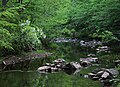 | The byway traverses along historic trade roads used by American Indians and early backcountry pioneers. The King of England gave much of the land along this byway to 18th century Scotch-Welsh settlers; much of the land surrounding this byway still used today for farming by those same decedents. Access to the byway is via I-40 at Exit 261 (Hillsborough) and onto Old NC 86. Following south on Old NC 86, cross over New Hope Creek and turn right onto Arthur Minnis Road (SR 1129), continue until Orange Grove Road (SR 1006) and take left, take left onto Dairyland Road (SR 1104), then left again onto Rocky Ridge Road. Once returning to Arthor Minnis Road and left back onto Old NC 86, the byway ends. | 10.0 | 16.1 | [9] |
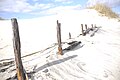
| Coastal Plain | Blue-Gray Scenic Byway | 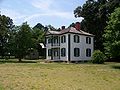 |  NC 58 NC 58 | 82.0 | 132.0 | [9] |
| Coastal Plain | Meteor Lakes Byway |  |  NC 242 NC 242 | 39.0 | 62.8 | [9] |
| Coastal Plain | Green Swamp Byway | |  NC 211 NC 211 | 53.0 | 85.3 | [9] |
| Coastal Plain | Brunswick Town Road |  | The byway begins at the intersection of NC 133 and Plantation Road (SR 1529), near Southport, and follows Plantation Road to Tryon Palace Road (SR 1533) and follow it to Brunswick Town State Historic Site. This byway showcases historical Brunswick County. | 3.0 | 4.8 | [9] |
| Coastal Plain | Cape Fear Historic Byway |  | Located in downtown Wilmington, it features scenic urban areas, colonial-era streets, the U.S.S. North Carolina, and the city parks. The following roads and highways that makeup this byway are: US 17, US 17 Bus., US 421, Third Street, Water Street, Front Street, Castle Street, Fifth Street and Lake Shore Drive. | 8.0 | 12.9 | [9] |
| Coastal Plain | Lafayette's Tour | |         US 13 / US 158 / US 258 / NC 43 / NC 58 / NC 125 / NC 137 / NC 561 / NC 903 US 13 / US 158 / US 258 / NC 43 / NC 58 / NC 125 / NC 137 / NC 561 / NC 903 | 173.0 | 278.4 | [9] |
| Coastal Plain | Tar Heel Trace |  |    NC 42 / NC 124 / NC 125 / NC 142 NC 42 / NC 124 / NC 125 / NC 142 | 53.0 | 85.3 | [9] |
| Coastal Plain | Edenton-Windsor Loop |  | 
   US 13 / US 17 / US 13 Bus. / NC 32 / NC 45 / NC 308 US 13 / US 17 / US 13 Bus. / NC 32 / NC 45 / NC 308 | 87.0 | 140.0 | [9] |
| Coastal Plain | Perquimans Crossing | 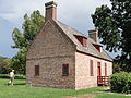 |
 US 17 Bus. / NC 37 US 17 Bus. / NC 37 | 3.0 | 4.8 | [9] |
| Coastal Plain | Pamlico Scenic Byway |  |    US 264 / NC 32 / NC 45 / NC 92 / NC 99 US 264 / NC 32 / NC 45 / NC 92 / NC 99 | 127.0 | 204.4 | [9] |
| Coastal Plain | Alligator River Route |  | The byway follows NC 94 north, from New Holland to Columbia, where it goes east along US 64 Bus. and US 64 to Manns Harbor and Roanoke Island. The byway features expansive wetlands, open farmlands, Alligator River National Wildlife Refuge and Lake Mattamuskeet. | 71.0 | 114.3 | [9] |
| Coastal Plain | Roanoke Voyages Corridor |  | The byway follows US 64 through Roanoke Island. It features Fort Raleigh National Historic Site (site of the first English settlement in North America), the North Carolina Aquarium, and Roanoke Island Festival Park. | 9.0 | 14.5 | [9] |
|