List of Washington State Scenic and Recreational Highways

Last updated

Washington State Scenic and Recreational Highways
WA Scenic and Recreational Highway.svg
Highway marker for the program
System information
Maintained by WSDOT
FormedApril 27, 1967 (1967-04-27) [1]
NotesDefined by RCW 47.39
Highway names
Interstates Interstate nn (I-nn)
US Highways U.S. Route nn (US nn)
State State Route nn (SR nn)
System links

The Washington State Scenic and Recreational Highways program is a system of scenic routes in the U.S. state of Washington.

Contents

History

A Scenic and Recreational Highway shield on SR 109 near Hoquiam Washington Scenic and Recreational Highway sign on SR 109 near Hoquiam, WA.jpg
A Scenic and Recreational Highway shield on SR 109 near Hoquiam

The passage of the Scenic and Recreational Highway Act of 1967, signed into law on April 27, 1967, established Washington's state scenic and recreational highway program. [1]

State byways

Key
Dagger-14-plain.pngAlso designated as a National Scenic Byway
Double-dagger-14-plain.pngAlso designated as an All-American Road
§Also designated as a National Forest Scenic Byway
List of Washington State Scenic and Recreational Highways
NameLength (mi) [2] Length (km)Southern or western terminusNorthern or eastern terminusDesignatedDescription
Cape Flattery Tribal Scenic Byway 1219 Cape Flattery Eastern Makah reservation limitsFollows Bayview Avenue and SR 112 through the Makah Indian Reservation [3]
Cascade Loop Scenic Byway Dagger-14-plain.png440710Loop in Snohomish, King, Chelan, Okanogan, Skagit, Whatcom and Island County countiesFollows US 2, US 97 Alternate, US 97, SR 153, SR 20, SR 525, SR 526 and I-5 around the North Cascades [4]
Cascade Valleys Scenic Byway 2845 SR 522 in Woodinville I-90 in North Bend 1993Follows SR 202 along the Sammamish and Snoqualmie rivers
Chuckanut Drive Scenic Byway 2134 I-5 in Burlington I-5 in Bellingham 1993Follows SR 11 through the Chuckanut Mountains [5]
Columbia River Gorge Scenic Byway 80130Eastern Washougal city limits US 97 in Maryhill 1967 [1] Follows SR 14 through the Columbia River Gorge National Scenic Area [6]
Cranberry Coast Scenic Byway 4877 US 101 in Raymond US 101 in Aberdeen 1967 [1] Follows SR 105 along Willapa Bay, the Pacific Ocean, and Grays Harbor
Hidden Coast Scenic Byway 4166 US 101 in Hoquiam Cuitan Street in Taholah 1967 [1] Follows SR 109 along the Pacific Coast [7]
Lewis and Clark Trail Scenic Byway 572921 Leadbetter Point State Park (north branch)
Cape Disappointment State Park (south branch)
US-12 at Idaho state line in Clarkston 1967Follows SR 103, SR 100, US 101, SR 401, SR 4, SR 432, I-5, SR 14, I-82, US 395, I-182, US 12 and SR 124 along the Columbia and Snake rivers [8]
Mount Baker Scenic Byway 5893 I-5 in Bellingham Artist Point, Mt. Baker Ski Area 1967 [1] Follows SR 542 to Mount Baker [9]
North Cascades Scenic Byway 140230 SR 9 in Sedro-Woolley SR 153 in Twisp Follows SR 20 through North Cascades National Park [10]
North Pend Oreille Scenic Byway Dagger-14-plain.png2743 SR 20 in Tiger BC 6 at Canada–US border Follows SR 31 in Pend Oreille County; also designated as part of the International Selkirk Loop [11]
Okanogan Trails Scenic Byway 83134 SR 153 in Pateros BC 97 at Canada–US border Follows US 97 along the Okanogan River [12]
Pacific Coast Scenic Byway Dagger-14-plain.png350560 US 101 at Oregon state line near Megler I-5 in Olympia Follows US 101 around the Olympic Peninsula [13]
Palouse Scenic Byway 208335 AdamsWhitman county line Idaho state line2003 [14] Follows SR 26, SR 27, SR 194, US 195, SR 271, SR 272 and SR 278 in Whitman County [15] [16]
San Juan Islands Scenic Byway 120190 [lower-alpha 1] Sidney, British Columbia SR 20 near Anacortes 2009 [17] Follows SR 20 Spur (San Juan Islands Ferry) through the San Juan Islands
Sherman Pass Scenic Byway 3556 SR 21 in Republic US 395 in Kettle Falls Follows SR 20 through Sherman Pass [18]
Spirit Lake Memorial Highway 5284 I-5 in Castle Rock Johnston Ridge Observatory Follows SR 504 towards Mount St. Helens; also designated as a National Forest Scenic Byway
Swiftwater Corridor Scenic Byway 4268 Wenatchee National Forest boundary I-90 in Ellensburg Follows SR 10, US 97, SR 903 and SR 970 in Kittitas County
Whidbey Scenic Isle Way 5487 Clinton ferry terminal Deception Pass Follows SR 525 and SR 20 on Whidbey Island [19]
White Pass Scenic Byway 119192 I-5 near Napavine SR 410 in Naches Follows US 12 through White Pass; also designated as a National Forest Scenic Byway [20]
Yakima Scenic Byway 76122 SR 14 in Maryhill I-82/US 12 in Union Gap Follows US 97 through the Yakama Indian Reservation
Yakima River Canyon Scenic Byway 1829 I-82 in Selah I-82 in Ellensburg Follows SR 821 through the Yakima River Canyon [21]

Agricultural scenic corridors

NameLength (mi)Length (km)Southern or western terminusNorthern or eastern terminusDesignatedDescription
Skagit Valley Agricultural Scenic Corridor 1829Starbird Road near Conway Bow Hill Road near Bow 2010 [22] Follows I-5 through the Skagit Valley

Former byways

National byways

In addition to the state scenic highways system, several routes in Washington are designated as National Scenic Byways and All-American Roads. [23]

Notes

  1. The San Juan Islands Scenic Byway includes a 30-mile (48 km) ferry route operated by Washington State Ferries between the islands.

Related Research Articles

A Pure Michigan Byway is the designation for a segment of the State Trunkline Highway System in the US state of Michigan that is a "scenic, recreational, or historic route that is representative of Michigan's natural and cultural heritage." The designation was created with the name Michigan Heritage Route by the state legislature on June 22, 1993, and since then six historic, seven recreational and seven scenic byways have been designated by the Michigan Department of Transportation (MDOT), and another two have been proposed. These byways have been designated in both the Upper and Lower peninsulas of the state. The current name was adopted on December 30, 2014, and it references the Pure Michigan tourism marketing campaign.

National Scenic Byway Road recognized by the USDOT for one or more of six "intrinsic qualities": archeological, cultural, historic, natural, recreational, and scenic

A National Scenic Byway is a road recognized by the United States Department of Transportation for one or more of six "intrinsic qualities": archeological, cultural, historic, natural, recreational, and scenic. The program was established by Congress in 1991 to preserve and protect the nation's scenic but often less-traveled roads and promote tourism and economic development. The National Scenic Byways Program (NSBP) is administered by the Federal Highway Administration (FHWA).

Washington State Route 20 Highway in Washington

State Route 20 (SR 20), also known as the North Cascades Highway, is a state highway that traverses the U.S. state of Washington. It is the state's longest highway, traveling 436 miles (702 km) across the northern areas of Washington, from U.S. Route 101 (US 101) at Discovery Bay on the Olympic Peninsula to US 2 near the Idaho state border in Newport. The highway travels across Whidbey Island, North Cascades National Park, the Okanagan Highland, the Kettle River Range, and the Selkirk Mountains. SR 20 connects several major north–south state highways, including Interstate 5 (I-5) in Burlington, US 97 through the Okanogan–Omak area, SR 21 in Republic, and US 395 from Kettle Falls to Colville.

Washington State Route 410 Highway in Washington

State Route 410 is a 107.44-mile (172.91 km) long state highway that traverses Pierce, King, and Yakima counties in the US state of Washington. It begins at an interchange with SR 167 in Sumner and travels southeast across the Cascade Range to a junction with U.S. Route 12 (US 12) in Naches. While the western part of SR 410 is a freeway that serves built-up, urban areas, the remainder of the route is a surface road that traverses mostly rural areas as it passes through the mountains.

State Route 4 (SR 4) is a 62.27-mile-long (100.21 km) state highway, serving the southwestern region of the U.S. state of Washington. The highway, also known as Ocean Beach Highway, travels east along the Columbia River from U.S. Route 101 (US 101) at Johnston's Landing through Pacific, Wahkiakum and Cowlitz counties to an interchange with Interstate 5 (I-5) in Kelso. SR 4 is designated as part of the Lewis and Clark Trail Scenic Byway, a state scenic byway, as well as part of the National Highway System.

State Route 11 (SR 11) is a 21.28-mile (34.25 km) long state highway that serves Skagit and Whatcom counties in the U.S. state of Washington. SR 11, known as Chuckanut Drive, begins at an interchange with Interstate 5 (I-5) north of Burlington and continues northwest through several small towns and the Chuckanut Mountains to the Fairhaven district of Bellingham, where the highway turns east and ends again at I-5.

Washington State Route 202 Highway in Washington

State Route 202 (SR 202) is a state highway in the U.S. state of Washington, serving part of the Seattle metropolitan area. It runs southeasterly for 31 miles (50 km) in the Eastside region of King County, connecting Woodinville, Redmond, Fall City, and North Bend. The highway begins at SR 522 in Woodinville, intersects SR 520 in Redmond and SR 203 in Fall City, and terminates at Interstate 90 (I-90) in North Bend. The entire highway is designated as the Cascade Valleys Scenic Byway, a state scenic and recreational highway.

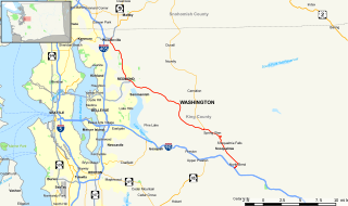
State Route 17 (SR 17) is a 136.67-mile-long (219.95 km) state highway serving the Columbia Plateau in the central region of the U.S. state of Washington. The highway travels through mostly rural areas of Franklin. Adams, Grant, Douglas, and Okanogan counties and is designated as part of the National Highway System between Mesa and Moses Lake and as the Coulee Corridor Scenic Byway between Othello and Coulee City for passing through the Grand Coulee. SR 17 begins in Mesa at an interchange with U.S. Route 395 (US 395) and travels north and intersects SR 26 near Othello before entering Moses Lake, where the highway intersects Interstate 90 (I-90) and travels as a partial expressway. SR 17 continues north, intersecting SR 28 in Soap Lake, through the Grand Coulee to a short concurrency with US 2 west of Coulee City. The highway turns northwest and crosses the Columbia River on the Columbia River Bridge at Bridgeport before ending at US 97 in Brewster at the southwestern edge of the Colville Indian Reservation.

State Route 27 (SR 27) is a 90-mile-long (145 km) state highway serving Whitman and Spokane counties, located in the eastern region of the U.S. state of Washington. The highway travels generally north from U.S. Route 195 (US 195) through Pullman, Palouse, Tekoa, and Spokane Valley to SR 290 north of an interchange with Interstate 90 (I-90). SR 27 serves the Palouse region as part of the Palouse Scenic Byway and travels between US 195 to the west and US 95 to the east in Idaho, with several auxiliary routes connecting to the two other highways.

Arkansas Scenic Byways

The Arkansas Scenic Byways Program is a list of highways, mainly state highways, that have been designated by the Arkansas Department of Transportation (ArDOT) as scenic highways. The Arkansas General Assembly designates routes for scenic byway status upon successful nomination. For a highway to be declared scenic, a group interested in preserving the scenic, cultural, recreational, and historic qualities of the route must be created. Mayors of all communities along the route and county judges from each affected county must be included in the organization. Scenic highways are marked with a circular shield in addition to regular route markers.

Washington State Route 124

State Route 124 (SR 124) is a state highway in Walla Walla County, Washington, United States. It spans 45 miles (72 km) from Burbank in the west to Waitsburg in the east, intersecting U.S. Route 12 (US 12) at both ends. The highway generally follows the Snake and Touchet rivers and intersects SR 125 near Prescott.

U.S. Route 2 (US 2) is a component of the United States Numbered Highway System that connects the city of Everett in the U.S. state of Washington to the Upper Peninsula of Michigan, with a separate segment that runs from Rouses Point, New York, to Houlton, Maine. Within Washington, the highway travels on a 326.36-mile-long (525.23 km) route that connects the western and eastern regions of the state as a part of the state highway system and the National Highway System. US 2 forms parts of two National Scenic Byways, the Stevens Pass Greenway from Monroe to Cashmere and the Coulee Corridor Scenic Byway near Coulee City, and an All-American Road named the International Selkirk Loop within Newport.

Dinosaur Diamond

The Dinosaur Diamond is a 486-mile (782 km) scenic and historic byway loop through the dinosaur fossil laden Uinta Basin of the U.S. states of Utah and Colorado. The byway comprises the following two National Scenic Byways:

National Forest Scenic Byway

The National Forest Scenic Byways are roads that have been designated by the U.S. Forest Service as scenic byways. Many are also National Scenic Byways (NSB). The program was initiated in 1987.

High Desert Discovery Scenic Byway

The High Desert Discovery Scenic Byway is a 127-mile-long (204 km) scenic highway in the southeastern part of the U.S. state of Oregon. It runs through the state's high desert country from the town of Burns to the unincorporated community of Fields. It was designated as an Oregon Scenic Byway in 2003. The highway is maintained by the Oregon Department of Transportation (ODOT). There are a number of points of interest along the route including several that are listed on the National Register of Historic Places.

Scenic byways in the United States

Many roads and highways in the United States are labeled scenic byways for having exceptional scenic, historical, archaeological, natural, cultural, or recreational significance. These scenic routes are usually formally designated by national, state, or local agencies in recognition of these qualities, and many are also preserved or managed with special legislation and funding beyond what is required for ordinary road maintenance.

Palouse Scenic Byway List of roads or other routes with the same name

The Palouse Scenic Byway is a Washington State Scenic and Recreational Highway in Whitman County, Washington that follows seven different highways in the Palouse region:

Cascade Loop Scenic Byway List of roads or other routes with the same name

The Cascade Loop Scenic Byway is a 440-mile-long (710 km) National Scenic Byway and Washington State Scenic and Recreational Highway encircling the North Cascades in the U.S. state of Washington. It follows eight different numbered highways:

References

  1. 1 2 3 4 5 6 Washington State Legislature (April 27, 1967). "Chapter 85: Scenic and Recreational Highway System" (PDF). In Kramer, A. Ludlow (ed.). 1967 Session Laws of the State of Washington Extraordinary Session, Fortieth Legislature. Session Laws of the State of Washington (1967 ed.). Olympia, Washington: Washington State Legislature. pp. 1772–1781. OCLC   42336168. Archived (PDF) from the original on September 6, 2015. Retrieved October 16, 2014.
  2. "Washington State's Scenic Byways & Road Trips" (PDF). Washington State Department of Commerce, Washington State Tourism, Washington State Department of Transportation . Retrieved October 16, 2014.
  3. "Cape Flattery Tribal Scenic Byway". Scenic Byways Program. Washington State Department of Transportation. Archived from the original on October 23, 2014. Retrieved October 16, 2014.
  4. "Cascade Loop Scenic Byways". Scenic Byways Program. Washington State Department of Transportation. Archived from the original on October 18, 2014. Retrieved October 16, 2014.
  5. "Chuckanut Drive Scenic Byway". Scenic Byways Program. Washington State Department of Transportation. Archived from the original on October 17, 2014. Retrieved October 16, 2014.
  6. "Columbia River Gorge Scenic Byway and Area". Scenic Byways Program. Washington State Department of Transportation. Archived from the original on October 23, 2014. Retrieved October 16, 2014.
  7. "Hidden Coast Scenic Byway". Scenic Byways Program. Washington State Department of Transportation. Archived from the original on October 23, 2014. Retrieved October 16, 2014.
  8. "Lewis and Clark Trail Scenic Byway". Scenic Byways Program. Washington State Department of Transportation. Archived from the original on October 23, 2014. Retrieved October 16, 2014.
  9. "Mt Baker Scenic Byway". Scenic Byways Program. Washington State Department of Transportation. Archived from the original on October 13, 2014. Retrieved October 16, 2014.
  10. "North Cascades Scenic Byway". Scenic Byways Program. Washington State Department of Transportation. Archived from the original on October 23, 2014. Retrieved October 16, 2014.
  11. "North Pend Oreille Scenic Byway". Scenic Byways Program. Washington State Department of Transportation. Archived from the original on October 22, 2014. Retrieved October 16, 2014.
  12. "Okanogan Trails Scenic Byway". Scenic Byways Program. Washington State Department of Transportation. Archived from the original on October 19, 2014. Retrieved October 16, 2014.
  13. "Pacific Coast Scenic Byway". Scenic Byways Program. Washington State Department of Transportation. Archived from the original on October 23, 2014. Retrieved October 16, 2014.
  14. Washington State Legislature (April 17, 2003). "Chapter 55: Scenic and Recreational Highway System" (PDF). 2003 Session Laws of the State of Washington. Session Laws of the State of Washington (2003 ed.). Olympia, Washington: Washington State Legislature. OCLC   42336168 . Retrieved October 16, 2014.
  15. "Palouse Scenic Byway". Scenic Byways Program. Washington State Department of Transportation. Archived from the original on October 10, 2014. Retrieved October 16, 2014.
  16. Washington State Legislature (April 20, 2011). "Chapter 123: Scenic and Recreational Highway System" (PDF). 2011 Session Laws of the State of Washington. Session Laws of the State of Washington (2011 ed.). Olympia, Washington: Washington State Legislature. OCLC   42336168 . Retrieved October 16, 2014.
  17. Washington State Legislature (April 29, 2009). "Chapter 277: Scenic and Recreational Highway System—Additions" (PDF). 2009 Session Laws of the State of Washington. Session Laws of the State of Washington (2009 ed.). Olympia, Washington: Washington State Legislature. OCLC   42336168 . Retrieved October 16, 2014.
  18. "Sherman Pass Scenic Byway". Scenic Byways Program. Washington State Department of Transportation. Archived from the original on October 18, 2014. Retrieved October 16, 2014.
  19. "Whidbey Scenic Isle Way". Scenic Byways Program. Washington State Department of Transportation. Archived from the original on October 18, 2014. Retrieved October 16, 2014.
  20. "White Pass Scenic Byway". Scenic Byways Program. Washington State Department of Transportation. Archived from the original on October 19, 2014. Retrieved October 16, 2014.
  21. "Yakima River Canyon Scenic Byway". Scenic Byways Program. Washington State Department of Transportation. Archived from the original on October 18, 2014. Retrieved October 16, 2014.
  22. Washington State Legislature (March 10, 2010). "Chapter 14: Scenic and Recreational Highway System—Agricultural Scenic Corridor" (PDF). 2010 Session Laws of the State of Washington. Session Laws of the State of Washington (2010 ed.). Olympia, Washington: Washington State Legislature. OCLC   42336168 . Retrieved October 16, 2014.
  23. "List of all National Scenic Byways and All-American Roads". Scenic America . Retrieved April 4, 2022.
  24. Cauvel, Kimberly (February 20, 2021). "440-mile Cascade Loop gets National Scenic Byway designation after years of effort". The Seattle Times. Retrieved April 4, 2022.
  25. "Grant dollars to add features on Chinook Scenic Byway". Enumclaw Courier-Herald . October 11, 2012. Retrieved April 4, 2022.
  26. Gary, Brad W. (September 23, 2005). "Coulee Corridor goes national as scenic byway". Columbia Basin Herald . Retrieved April 4, 2022.
  27. Sharman, Christianne (October 23, 2005). "The Loop is a drive filled with wonder". The Spokesman-Review . Retrieved April 4, 2022.
  28. Paulson, Michael (June 10, 1998). "Stretch of Rainier road joins scenic elite". Seattle Post-Intelligencer . p. B1.
  29. "U.S. Transportation Deputy Secretary Downey Announces New All-American Roads, National Scenic Byways in 20 States" (Press release). United States Department of Transportation. June 15, 2000. Retrieved April 4, 2022.