Navajo Nation Scenic Byways | |
---|---|
System information | |
Formed | 1996 [1] |
System links | |
Navajo Nation Scenic Byways, also called Navajo Nation Scenic Roads, are roads to Navajo Nation sites of scenic or historic significance.
The plans for Navajo National Scenic Byways were developed by a task force including the Arizona Department of Transportation, and Bureau of Indian Affairs. [2] It is administered with the Federal Highway Administration. [3]
The following table is a list of Navajo Nation Scenic Byways: [3]
Byway | Length | Notes | Designation |
---|---|---|---|
Diné Biítah "Among the People" Scenic Road | 103 miles | The scenic byway begin at Window Rock, Arizona, the Navajo Nation capitol, and travels along BIA Route 12 and Navajo Route 64 in New Mexico and Arizona to sacred Navajo places. Sites on the road include archaeological sites at Canyon de Chelly National Monument, the Navajo Nation Museum, and the Navajo Code Talker Monument. [3] | |
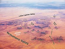
Kayenta-Monument Valley Scenic Road | 27.7 miles | The scenic byway, along U.S. Route 163, passes by "unmissable monoliths" of Monument Valley, like Totem Pole, Three Sisters, and Merrick Butte. [3] | |
Naat’tsis’aan (Navajo Mountain) Scenic Road | 68 miles | The road travels along Arizona State Route 98 through historic, sacred lands of the Paiute, Hopi and Navajo. The earliest of these were in the area 8,000 B.C. or earlier. It includes the Navajo's most sacred mountain, Naat'tsis'aan, or Navajo Mountain. Other sites are Antelope Canyon and the LeChee Rock. [3] | |
Tse’nikani (Flat Mesa Rock) Scenic Road | 48 miles | Red sandstone mesas, buttes and spires make up the landscape along U.S. Route 191 by Mexican Hat, Utah. [3] | |
Vermilion Cliffs Scenic Road | 82 miles | It is a scenic road through Marble Canyon, by Vermillion Cliffs and across the Navajo Bridge. The landscape scenery changes dramatically along the route with a 4,500 feet (1,400 m) change in elevation. [3] | |
A related byway is the Trail of Ancients Scenic Byway in New Mexico. It was designated a byway for its prehistoric archaeological sites. [3]
A Pure Michigan Byway is the designation for a segment of the State Trunkline Highway System in the US state of Michigan that is a "scenic, recreational, or historic route that is representative of Michigan's natural and cultural heritage." The designation was created with the name Michigan Heritage Route by the state legislature on June 22, 1993, and since then six historic, seven recreational and seven scenic byways have been designated by the Michigan Department of Transportation (MDOT), and another two have been proposed. These byways have been designated in both the Upper and Lower peninsulas of the state. The current name was adopted on December 30, 2014, and it references the Pure Michigan tourism marketing campaign.
U.S. Route 491 (US 491) is a north–south U.S. Highway serving the Four Corners region of the United States. It was created in 2003 as a renumbering of U.S. Route 666 (US 666). With the US 666 designation, the road was nicknamed the "Devil's Highway" because of the significance of the number 666 to many Christian denominations as the Number of the Beast. This Satanic connotation, combined with a high fatality rate along the New Mexico portion, convinced some people the highway was cursed. The problem was compounded by persistent sign theft. These factors led to two efforts to renumber the highway, first by officials in Arizona, then by those in New Mexico. There have been safety improvement projects in recent years, and fatality rates have subsequently decreased.
A National Scenic Byway is a road recognized by the United States Department of Transportation for one or more of six "intrinsic qualities": archeological, cultural, historic, natural, recreational, and scenic. The program was established by Congress in 1991 to preserve and protect the nation's scenic but often less-traveled roads and promote tourism and economic development. The National Scenic Byways Program (NSBP) is administered by the Federal Highway Administration (FHWA).
State Route 67 is a 43.4 mi (69.8 km) long, north–south state highway in northern Arizona. Also called the Kaibab Plateau – North Rim Parkway, SR 67 is the sole road that links U.S. Route 89A at Jacob Lake to the North Rim of Grand Canyon National Park. Along the route, the road heads through the national park as well as Kaibab National Forest and traverses extensive coniferous forests. The section inside the national park is maintained by the National Park Service (NPS), whereas the section north of the entrance, completely within Kaibab National Forest, is owned by the Arizona Department of Transportation (ADOT). The road was built in the late 1920s and improved through the 1930s. In 1941, the road received its number, and was given its designation as the parkway in the 1980s. The parkway has received designations as a National Forest Scenic Byway as well as a National Scenic Byway.
The Mount Evans Scenic Byway is a 49-mile (79 km) National Forest Scenic Byway and Colorado Scenic and Historic Byway located in Clear Creek and Jefferson counties, Colorado, United States. The byway ascends to 14,140 feet (4,310 m) of elevation near the 14,271-foot (4,350 m) summit of Mount Evans, making it the highest paved road in North America The byway visits Echo Lake Park, the Mount Goliath Natural Area, the Dos Chappell Nature Center, and Summit Lake Park on its way to the summit. A fee is charged to travel State Highway 5 to the summit and vehicles over 30 feet (9.1 m) long are not allowed, although they are allowed on State Highway 103 which reaches its highest elevation of 11,020 feet (3,359 m) at Juniper Pass.
The National Forest Scenic Byways are roads that have been designated by the U.S. Forest Service as scenic byways. Many are also National Scenic Byways (NSB). The program was initiated in 1987.
The Trail of the Ancients is a collection of National Scenic Byways located in the U.S. Four Corners states of Utah, Colorado, New Mexico, and Arizona. These byways comprise:
A scenic Byway in Ohio can be any interstate, national highway, state highway, County road, municipal street, or Township road in the State of Ohio as designated by the director of transportation.
The High Desert Discovery Scenic Byway is a 127-mile-long (204 km) scenic highway in the southeastern part of the U.S. state of Oregon. It runs through the state's high desert country from the town of Burns to the unincorporated community of Fields. It was designated as an Oregon Scenic Byway in 2003. The highway is maintained by the Oregon Department of Transportation (ODOT). There are a number of points of interest along the route including several that are listed on the National Register of Historic Places.
The Trail of the Ancients is a New Mexico Scenic Byway to prehistoric archaeological and geological sites of northwestern New Mexico. It provides insight into the lives of the Ancestral Puebloans and the Navajo, Ute, and Apache peoples. Geological features include canyons, volcanic rock features, and sandstone buttes. Several of the sites are scenic and wilderness areas with recreational opportunities.
Many roads and highways in the United States are labeled scenic byways for having exceptional scenic, historical, archaeological, natural, cultural, or recreational significance. These scenic routes are usually formally designated by national, state, or local agencies in recognition of these qualities, and many are also preserved or managed with special legislation and funding beyond what is required for ordinary road maintenance.