
Burnley is a town in Lancashire, England, with a 2001 population of 73,021. It is 21 miles (34 km) north of Manchester and 20 miles (32 km) east of Preston, at the confluence of the River Calder and River Brun.
Padiham is a town and civil parish on the River Calder, about three miles (5 km) west of Burnley, Lancashire, England. It belongs to the Borough of Burnley. Originally by the River Calder, it is edged by the foothills of Pendle Hill to the north-west and north-east. The United Kingdom Census 2011 gave a parish population of 10,098, estimated in 2019 at 10,138.

Albert Square is a public square in the centre of Manchester, England. It is dominated by its largest building, the Grade I listed Manchester Town Hall, a Victorian Gothic building by Alfred Waterhouse. Other smaller buildings from the same period surround it, many of which are listed.

Anfield Cemetery, or the City of Liverpool Cemetery, is located in Anfield, a district of Liverpool, Merseyside, England. It lies to the northeast of Stanley Park, and is bounded by Walton Lane to the west, Priory Road to the south, a railway line to the north, and the gardens of houses on Ince Avenue to the east. The cemetery grounds are included in the National Register of Historic Parks and Gardens at Grade II*.
Dunnockshaw or Dunnockshaw and Clowbridge is a civil parish in the borough of Burnley, in Lancashire, England. The parish is situated between Burnley and Rawtenstall. According to the United Kingdom Census 2011, the parish has a population of 185.

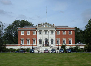
Capesthorne Hall is a country house near the village of Siddington, Cheshire, England. The house and its private chapel were built in the early 18th century, replacing an earlier hall and chapel nearby. They were built to Neoclassical designs by William Smith and (probably) his son Francis. Later in the 18th century, the house was extended by the addition of an orangery and a drawing room. In the 1830s the house was remodelled by Edward Blore; the work included the addition of an extension and a frontage in Jacobean style, and joining the central block to the service wings. In about 1837 the orangery was replaced by a large conservatory designed by Joseph Paxton. In 1861 the main part of the house was virtually destroyed by fire. It was rebuilt by Anthony Salvin, who generally followed Blore's designs but made modifications to the front, rebuilt the back of the house in Jacobean style, and altered the interior. There were further alterations later in the 19th century, including remodelling of the Saloon. During the Second World War the hall was used by the Red Cross, but subsequent deterioration prompted a restoration.

Clifton Park and Museum is a city park and municipal museum located in Clifton Park, Rotherham, South Yorkshire, England. Clifton Park Museum is located in Clifton House and one of several publicly owned museums and visitor attractions administered by the Metropolitan Borough of Rotherham. The house is the headquarters of Heritage Services, which also includes the York and Lancaster Regimental Museum and Archives and Local Studies. It is a Grade II* listed building. Clifton Park is a visitor attraction with facilities including a skate park, rockery, memorial park and children's play areas. It is also Grade II listed with Historic England.

Armley Park,, is a large public park located next to Stanningley Road in Armley, on the outskirts of Leeds, in West Yorkshire, Northern England.

Holy Trinity Chapel is a private chapel adjacent to Capesthorne Hall, near the village of Siddington, Cheshire, England. It is recorded in the National Heritage List for England as a designated Grade II* listed building. It is an Anglican church in the diocese of Chester, the archdeaconry of Macclesfield and the deanery of Macclesfield. Its benefice is combined with those of St James and St Paul, Marton, Christ Church, Eaton, and All Saints, Siddington.

Peel Park is a 22.6-hectare (56-acre) urban public park in the Bolton and Undercliffe area of Bradford, England, located about 0.75 miles (1.2 km) north-east of the city centre, and named after Sir Robert Peel (1788–1850). Peel Park was Bradford's first public park and is on the English Heritage and National Register of Historic Parks and Gardens online databases. The park is a Green Flag Award winner and has been for a number of years.
Warrington Town Hall is in the town of Warrington, Cheshire, England. It consists of a house, originally called Bank Hall, flanked by two detached service wings at right angles to the house, one on each side. The house and the service wings are each recorded in the National Heritage List for England as designated Grade I listed buildings. Being in that part of the town north of the River Mersey, the house falls within the historic county of Lancashire. The architectural historian Nikolaus Pevsner declared it to be "the finest house of its date in south Lancashire".

Hapton is a village and civil parish in Lancashire, England, 3 miles (4.8 km) west of Burnley, with a railway station on the East Lancashire Line. At the United Kingdom Census 2011, it had a population of 1,979.
The Thursby Baronetcy, of Ormerod House in the Parish of Burnley in the County Palatine of Lancaster and of Holmhurst in the Parish of Christchurch in the County of Southampton, was a title in the Baronetage of the United Kingdom. It was created on 26 July 1887 for John Hardy Thursby, then Honorary Colonel of the 3rd Battalion, East Lancashire Regiment.
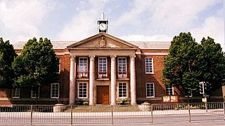
Burnley is a town in Lancashire, England. Its unparished area contains 190 buildings that are recorded in the National Heritage List for England as designated listed buildings. Of these, one is listed at Grade I, the highest of the three grades, three are at Grade II*, the middle grade, and the others are at Grade II, the lowest grade.

The Church of St Mary of the Assumption is in Yorkshire Street, Burnley, Lancashire, England. It is an active Roman Catholic parish church in the diocese of Salford. The church is recorded in the National Heritage List for England as a designated Grade II listed building. It was built between 1846 and 1849 to replace a smaller chapel on a different site. The church was designed by Weightman and Hadfield in Decorated style, and a chapel was added to it in 1879.
The Dulwich Old College War Memorial is located in the forecourt of Dulwich Old College on College Road in Dulwich in the London Borough of Southwark. It marks the deaths of the former pupils of the college who died in the First World War between 1914 and 1919. The memorial is made from Hopton Wood stone and was designed by William Douglas Caröe. It was unveiled in 1921. It has been grade II listed on the National Heritage List for England since May 2010. The heritage listing places the memorial within a "visual and contextual relationship" with the Grade II listed Old College building and the entrance gates and piers of the Old College, also Grade II listed.

Bank Hall Colliery was a coal mine on the Burnley Coalfield in Burnley, Lancashire near the Leeds and Liverpool Canal. Sunk in the late 1860s, it was the town's largest and deepest pit and had a life of more than 100 years.

Mesnes Park ( is a Victorian public park dating from 1878 in Wigan, Greater Manchester, UK.

Thompson Park is a formal Edwardian park in Burnley, Lancashire. It was opened to the public in 1930.
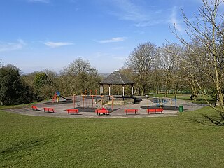
Scott Park is a public park in Burnley, Lancashire. It covers 7.9 hectares and was opened in 1895. Located south of the town centre, attractions include tennis courts, a children's play area, a bandstand, and bowling greens.


