Thompson Park (Burnley)

Last updated
Thompson Park
Thompson Park - geograph.org.uk - 679525.jpg
Gardens in Thompson Park
Thompson Park (Burnley)
TypePublic
Location Burnley, Lancashire
Coordinates 53°47′45″N2°14′13″W / 53.7957°N 2.2370°W / 53.7957; -2.2370 Coordinates: 53°47′45″N2°14′13″W / 53.7957°N 2.2370°W / 53.7957; -2.2370
Created1930
Operated by Burnley Borough Council
StatusGrade II English Heritage
Awards Green Flag

Thompson Park is a formal Edwardian park in Burnley, Lancashire. It was opened to the public in 1930.

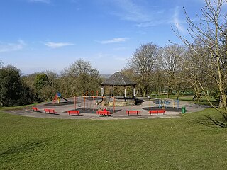
Located near the town centre, features include a boating lake, paddling pool, Italian gardens and a playground. Largely ornamental by design, the park contains a large number of flower beds and a rose garden. Dogs are banned from entering the park. [1]

The land that the park occupies was part of the estate of Bank Hall. Historically known as Bank Top, it was acquired by a colliery-owner, the Rev. John Hargreaves, who had built the hall on Colne Road by 1796. Later inherited by Charlotte Anne Hargreaves, it became the home of herself and her husband, General Sir James Yorke Scarlett, a hero of the Battle of Balaclava. As the couple produced no children, the hall and shares in the executors of John Hargreaves' company passed to Charlotte's sister, Eleanor Mary, who was married to the Rev. William Thursby, and thus came under the control of the Thursby family. The company's Bank Hall Colliery, the town's largest and deepest coal mine, was developed from 1865 on land to the northeast of the park. [2]

The lands of the estate gradually diminished as the town expanded. In 1878 Godley Lane, which curved along the southwest boundary, was closed to be replaced by the straight Ormerod Road. In 1888, Sir John Hardy Thursby donated 11.2 hectares (28 acres) to the town to create Queens Park, which lies to the east. [3] The town's education committee constructed a building at the south end to house the technical, art and girls high schools, which opened in 1909. [4] John's son, Sir J O S Thursby, also gave land to the town, lying between Bank Hall and Burnley Central railway station which opened as Thursby Gardens in 1910. [5] The hall itself was sold in 1916, becoming a maternity hospital. [6]

In 1920, a local cotton mill owner, James Witham Thompson, bequeathed £50,000 to the council to build a public park (equivalent to about £1.9 million in 2018). [7] The council obtained the option to purchase the land from Sir J O S Thursby, completing the transaction in October 1922. Construction work began in 1928 and the official opening took place on 16 July 1930. [8]

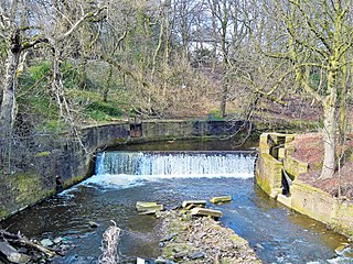
The River Brun runs through the park, with the Leeds and Liverpool Canal forming its eastern boundary. The double-arched Sandy Holme Aqueduct carries the canal over the river at the park's northern tip. The land on the south-east of the river was previously farmland, a plantation, and allotments, with the area on the other bank formerly part of the grounds of the hall. A weir was constructed to provide a water supply to the approximately 1.2-hectare (3.0-acre) boating lake and a paddling pool. Two bridges were built over the river and an ornamental bridge over the lake. A rose garden, herbaceous garden and Italian garden were laid-out, and a 22-metre (72 ft) by 8.4-metre (28 ft) conservatory was erected for exotic plants. Additional buildings included a boathouse, a tea-room pavilion and a lodge house, with much of the work done by the unemployed under the supervision of the council. [8] [9]

The park also contains a memorial, erected shortly after it opened, commemorating Dr James Mackenzie, a pioneering Scottish cardiologist who spent over 25 years as a general practitioner in the town. The memorial consists of a bronze bust by L. F. Roslyn set in a pink granite niche in a sandstone wall with stepped sides and top. The niche is round-headed with a bronze garland around the top, and with the life-sized bust standing on an inscribed pedestal. [10]

During World War II the park was used for growing vegetables and the only bomb to fall on Burnley landed near the conservatory on 27 October 1940. In the 1970s an open air school on the northern side of the park was demolished and the park expanded into the area. [8]

In 2017, the local council received a grant of £861,000 towards the cost of restoring the park and celebrating its heritage. Work began in the August of that year. [1]

Thompson Park is listed as a Grade II public park by English Heritage [8] and has also been awarded the Green Flag Award for its high standards. [11]

See also

Related Research Articles

Burnley Town in England

Burnley is a town and the administrative centre of the wider Borough of Burnley in Lancashire, England, with a 2001 population of 73,021. It is 21 miles (34 km) north of Manchester and 20 miles (32 km) east of Preston, at the confluence of the River Calder and River Brun.

Padiham Town in Lancashire, England

Padiham is a town and civil parish on the River Calder, about three miles (5 km) west of Burnley, Lancashire, England. It forms part of the Borough of Burnley. Originally by the River Calder, it is edged by the foothills of Pendle Hill to the north-west and north-east. The United Kingdom Census 2011 gave a parish population of 10,098, estimated in 2019 at 10,138.

Borough of Burnley Borough in England

The Borough of Burnley is a local government district with the borough status in Lancashire, England. It has an area of 42.7 square miles (110.7 km2) and a population of 88,920 (mid-2019 est.), and is named after its largest town, Burnley. Other notable settlements include Padiham, Hapton, Worsthorne, Briercliffe and Cliviger.

Brierfield, Lancashire Town in Lancashire, England

Brierfield is a town and civil parish in the Borough of Pendle, in Lancashire, England. It is 2.5 miles (4.0 km) north east of Burnley, 1 mile (1.6 km) south west of Nelson, and 0.5 miles (0.8 km) north east of Reedley. The parish had a population of 8,193, at the census of 2011.

Oswaldtwistle Human settlement in England

Oswaldtwistle is a town in the Hyndburn borough of Lancashire, England, 3 miles (5 km) southeast of Blackburn, contiguous with Accrington and Church. The town has a rich industrial heritage, being home to James Hargreaves, inventor of the spinning jenny and Sir Robert Peel of calico printing fame. The Leeds and Liverpool Canal passes through the town and was responsible for the export of much of the area's cotton produce.

Colne Human settlement in England

Colne is a market town and civil parish in the Borough of Pendle, Lancashire, England. 2.5 miles northeast of Nelson, 6 mi (9.7 km) north-east of Burnley, 25 mi (40 km) east of Preston and 30 mi (48 km) west of Leeds. The cross allows a market to be held there and dates back to the 15th century. The cross was originally at the junction of Colne Lane and Church Street. It was first moved to the grounds of The Gables on Albert Road, the location of Colne Library until around 1970. It has now been relocated to outside the Market Hall on Market Street, part of the main road through the town centre.

Poynton A town in north-west England

Poynton is a town in Cheshire, England, on the easternmost fringe of the Cheshire Plain. It is 11 miles (18 km) southeast of Manchester, 7 miles (11 km) north of Macclesfield and 5 miles (8 km) south of Stockport.

Felling, Tyne and Wear Human settlement in England

Felling is an eastern suburb of Gateshead, Tyne and Wear, England. The town was formed when three villages coalesced in the 19th century. Historically part of County Durham, the town was subsumed into the metropolitan borough of Gateshead in 1974. It lies on the B1426 Sunderland Road and the A184 Felling bypass, less than 1 mile (1.6 km) east of Gateshead town centre, 1 mile (1.6 km) south east of Newcastle-upon-Tyne and 10 miles north west of the City of Sunderland. In 2011, Felling had a population of 8,908.

River Brun River in eastern Lancashire, England

The River Brun is a river in eastern Lancashire. It is approximately 4.5 miles (7.2 km) long and has a catchment area of 9.32 square miles (24.134 km2).

Cliviger Human settlement in England

Cliviger is a civil parish in the Borough of Burnley, in Lancashire, England. It is situated to the southeast of Burnley, and northwest of Todmorden. According to the 2011 census, the parish has a population of 2,238.

Hapton, Lancashire Human settlement in England

Hapton is a village and civil parish in Lancashire, England, 3 miles (4.8 km) west of Burnley, with a railway station on the East Lancashire Line. At the United Kingdom Census 2011, it had a population of 1,979.

The Thursby Baronetcy, of Ormerod House in the Parish of Burnley in the County Palatine of Lancaster and of Holmhurst in the Parish of Christchurch in the County of Southampton, was a title in the Baronetage of the United Kingdom. It was created on 26 July 1887 for John Hardy Thursby, then Honorary Colonel of the 3rd Battalion, East Lancashire Regiment.

Lancashire Coalfield Coal mining region in England

The Lancashire Coalfield in North West England was an important British coalfield. Its coal seams were formed from the vegetation of tropical swampy forests in the Carboniferous period over 300 million years ago.

Hameldon Hill

Hameldon Hill is a Carboniferous sandstone hill with a summit elevation of 409 metres (1,342 ft), situated between the towns of Burnley and Accrington in Lancashire, England. It is listed as a "HuMP" or "Hundred Metre Prominence", its parent being Freeholds Top, a Marilyn near Bacup.

Burnley Coalfield Coal mining region in England

The Burnley Coalfield is the most northerly portion of the Lancashire Coalfield. Surrounding Burnley, Nelson, Blackburn and Accrington, it is separated from the larger southern part by an area of Millstone Grit that forms the Rossendale anticline. Occupying a syncline, it stretches from Blackburn past Colne to the Yorkshire border where its eastern flank is the Pennine anticline.

Bank Hall Colliery Decommissioned coal mine in Lancashire

Bank Hall Colliery was a coal mine on the Burnley Coalfield in Burnley, Lancashire near the Leeds and Liverpool Canal. Sunk in the late 1860s, it was the town's largest and deepest pit and had a life of more than 100 years.

Burnley Embankment Waterway in the United Kingdom

The Burnley Embankment is an embankment carrying the Leeds and Liverpool Canal across the Calder and Brun valleys in Burnley, Lancashire. Also known as the Straight Mile, the embankment is 1,256 yards long and the canal runs up to 60 feet (18 m) above the valley floor. The structure was chosen as one of the original Seven Wonders of the Waterways, and has been awarded a Red Wheel by the Transport Trust.

Queens Park, Burnley Park in Burnley, United Kingdom

Queens Park is a public park in Burnley, Lancashire. It covers 11.2 hectares and was opened in 1893, making it Burnley's oldest park.

Scott Park Park in Burnley, United Kingdom

Scott Park is a public park in Burnley, Lancashire. It covers 7.9 hectares and was opened in 1895. Located south of the town centre, attractions include tennis courts, a children's play area, a bandstand, and bowling greens.

References

  1. 1 2 "Thompson Park". Burnley Borough Council. Retrieved 8 February 2020.
  2. Nadin, Jack (1997), British Mining No. 58 The Coal Mines of East-Lancashire, Northern Mine Research Society, pp. 9, 17, ISBN   0901450480
  3. Historic England. "Queens Park, Burnley (1001539)". National Heritage List for England . Retrieved 9 April 2020.
  4. Bennett, Walter (1951), The History of Burnley, vol. 4, Burnley Corporation, pp. 185–186, OCLC   220326580
  5. Bennett, Walter (1951), The History of Burnley, vol. 4, Burnley Corporation, p. 57, OCLC   220326580
  6. Bennett, Walter (1951), The History of Burnley, vol. 4, Burnley Corporation, p. 201, OCLC   220326580
  7. Officer, Lawrence H. (2009). "Five Ways to Compute the Relative Value of a UK Pound Amount, 1270 to Present". MeasuringWorth. Retrieved 4 March 2020.
  8. 1 2 3 4 Historic England. "Thompson Park (1001496)". National Heritage List for England . Retrieved 4 March 2020.
  9. "OS 1:10,560". maps.nls.uk. National Library of Scotland. 1949–1969. Retrieved 4 March 2020.
  10. Historic England. "Mackenzie Memorial in Thompson Park, Burnley (1244999)". National Heritage List for England . Retrieved 15 March 2020.
  11. "Thompson Park, Burnley". Burnley.co.uk. Retrieved 8 February 2020.