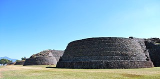
Tzintzuntzan was the ceremonial center of the pre-Columbian Purépecha capital of the same name. The name comes from the Purépecha word Ts’intsuntsani, which means "place of hummingbirds." The site includes at least 1,000 archaeological features in an area that is at least 1,075 hectares.

Michoacán, formally Michoacán de Ocampo, officially the Estado Libre y Soberano de Michoacán de Ocampo, is one of the 31 states which, together with Mexico City, comprise the Federal Entities of Mexico. The state is divided into 113 municipalities and its capital city is Morelia. The city was named after José María Morelos, a native of the city and one of the main heroes of the Mexican War of Independence.
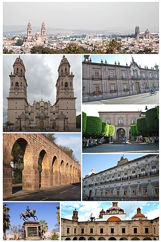
Morelia is a city and municipal seat of the municipality of Morelia in the north-central part of the state of Michoacán in central Mexico. The city is in the Guayangareo Valley and is the capital and largest city of the state. The main pre-Hispanic cultures here were the Purépecha and the Matlatzinca, but no major cities were founded in the valley during this time. The Spanish took control of the area in the 1520s. The Spanish under Viceroy Antonio de Mendoza founded a settlement here in 1541 with the name of Valladolid, which became rival to the nearby city of Pátzcuaro for dominance in Michoacán. In 1580, this rivalry ended in Valladolid's favor, and it became the capital of the viceregal province. After the Mexican War of Independence, the city was renamed Morelia in honor of José María Morelos, who hailed from the city. In 1991, the city was declared a UNESCO World Heritage Site for its well-preserved historical buildings and layout of the historic center. It is tradition to name people born on September 30 after the city.
Michoacán is a state in western Mexico that is divided into 113 municipalities. According to the 2020 Mexican census, it is the ninth most populated state with 4,748,846 inhabitants and the 16th largest by land area spanning 58,598.7 square kilometres (22,625.1 sq mi).

Zacapu, is a city and surrounding municipality in the Nahuatzen mountains of Michoacán, Mexico. It is located at 19°49′N101°48′W. The municipality has an area of 455.96 km2 (176.05 sq mi). Geographic features in Zacapu include the Cerro del Tecolote mountain range and Zacapu Lagoon.

Lake Pátzcuaro is a lake in the municipality of Pátzcuaro, Michoacán, Mexico.

Pátzcuaro is a city and municipality located in the state of Michoacán, Mexico. The town was founded sometime in the 1320s, at first becoming the capital of the Purépecha Empire and later its ceremonial center. After the Spanish took over, Vasco de Quiroga worked to make Pátzcuaro the capital of the New Spain province of Michoacán, but after his death, the capital would be moved to nearby Valladolid. Pátzcuaro has retained its colonial and indigenous character since then, and it has been named one of the 111 "Pueblos Mágicos" by the government of Mexico. Pátzcuaro, and the lake region to which it belongs, is well known as a site for Day of the Dead celebrations.

Vasco de Quiroga was the first bishop of Michoacán, Mexico, and one of the judges (oidores) in the second Real Audiencia of Mexico – the high court that governed New Spain – from January 10, 1531, to April 16, 1535.

The Purépecha Empire, also known by the term Iréchikwa, was a polity in pre-Columbian Mexico. Its territory roughly covered the geographic area of the present-day Mexican state of Michoacán, as well as parts of Guanajuato, Guerrero, and Jalisco. At the time of the Spanish conquest, it was the second-largest state in Mesoamerica. The state is also known as the Tarascan Empire, an exonym often considered pejorative by the Purépecha people.

Ihuatzio, which translates to "Land of Coyotes" in the Purépecha language, is a town located near Lake Pátzcuaro in the Mexican state of Michoacán. It was once the capital of the Purépecha kingdom. It was the capital until the change to Tzintzuntzan. As of the year 2020, it has a total population of 3,950.

Acuitzio Municipality is a municipality located in the central region of the Mexican state of Michoacán.

Santa Clara del Cobre is a Magical town and municipality located in the center of the state of Michoacán, Mexico, 18 km from Pátzcuaro and 79 km from the state capital of Morelia. While the official name of the municipality is Salvador Escalante, and the town is often marked as "Villa Escalante" or "Salvador Escalante" on maps, both entities are interchangeably called Santa Clara del Cobre. The town is part of the Pátzcuaro region of Michoacán, and ethnically dominated by the Purépecha people. These people have been working with copper since the pre-Hispanic era, and led to this town's dominance in copper crafts over the colonial period (1519–1821) until well into the 19th century. Economic reverses led to the industry's near-demise here until efforts in the 1940s and 1970s managed to bring the town's work back into prominence.
The municipality of Lagunillas is a municipality in the Mexican state of Michoacán. Its municipal seat is Lagunillas, Michoacán. It is bordered on the north and east by Morelia, south and west with Huiramba and Tzintzuntzan. Its distance from the state capital is 30 kilometers by the federal highway Morelia-Patzcuaro number 14. Lagunillas owes its name to the system of lakes and ponds that existed in ancient times in the region. During the colony a population center type hacendario. This place was called “Hacienda de Lagunillas”. By running the years the economic and social life revolved around the farm until the year of 1930 when “La Reforma Agraria” took place.
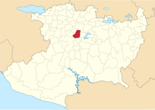
Tzintzuntzan Municipality is a municipality in the Mexican state of Michoacán. The seat is Tzintzuntzan, Michoacán.

Tzintzuntzan is a town in Tzintzuntzan Municipality located in the north of Michoacán state, 53 km from the capital of Morelia and 17.5 km from Pátzcuaro, located on the northeast shore of Lake Pátzcuaro. It is best known as the former capital of the Tarascan state until it was conquered by the Spanish in the 1520s. Today, Tzintzuntzan is a small town with two major attractions, the archeological site of Tzintzuntzan and the former monastery complex of San Francisco. The municipality contains another important archeological site called Ihuatzio. It is also notable for its festivals, which include the Festival of Señor del Rescate, Day of the Dead celebrations and a cultural event related to New Year's.

Huandacareo is an archaeological zone located about 60 kilometers north of the city of Morelia, in the state of Michoacán.

Ihuatzio is an archeological site in Michoacán state, Mexico. It is at the southern slopes of Cerro Tariaqueri, just north of the Ihuatzio town, in the Tzintzuntzan municipality.

Michoacán handcrafts and folk art is a Mexican regional tradition centered in the state of Michoacán, in central/western Mexico. Its origins traced back to the Purépecha Empire, and later to the efforts to organize and promote trades and crafts by Vasco de Quiroga in what is now the north and northeast of the state. The state has a wide variety of over thirty crafts, with the most important being the working of wood, ceramics, and textiles. A number are more particular to the state, such as the creation of religious images from corn stalk paste, and a type of mosaic made from dyed wheat straw on a waxed board. Though there is support for artisans in the way of contests, fairs, and collective trademarks for certain wares, Michoacán handcrafts lack access to markets, especially those catering to tourists.

Jiménez is a municipality in the Mexican state of Michoacán. It is located approximately 65 kilometres (40 mi) west of the state capital of Morelia.
Nahuatzen is a municipality in the Mexican state of Michoacán. It is located approximately 75 kilometres (47 mi) west of the state capital of Morelia.

