Dirk Hartog Island is an island off the Gascoyne coast of Western Australia, within the Shark Bay World Heritage Area. It is about 80 kilometres long and between 3 and 15 kilometres wide and is Western Australia's largest and most western island. It covers an area of 620 square kilometres and is approximately 850 kilometres north of Perth. It was named after Dirk Hartog, a Dutch sea captain, who first encountered the Western Australian coastline close to the 26th parallel south latitude, which runs through the island. After leaving the island, Hartog continued his voyage north-east along the mainland coast. Hartog gave the Australian mainland one of its earliest known names, as Eendrachtsland, which he named after his ship Eendracht, meaning "concord". The island is now the location of a major environmental reconstruction project, Return to 1616, that has seen all introduced livestock and feral animals removed, with eleven native species now in various stages of reintroduction.

The African penguin, also known as Cape penguin or South African penguin, is a species of penguin confined to southern African waters. Like all extant penguins, it is flightless, with a streamlined body and wings stiffened and flattened into flippers for a marine habitat. Adults weigh an average of 2.2–3.5 kg (4.9–7.7 lb) and are 60–70 cm (24–28 in) tall. The species has distinctive pink patches of skin above the eyes and a black facial mask. The body's upper parts are black and sharply delineated from the white underparts, which are spotted and marked with a black band. The pink glands above their eyes help them with thermoregulation. To cope with changing temperatures, blood is sent to the glands to be cooled by the air.
The Gascoyne region is one of the nine administrative regions of Western Australia. It is located in the north west of Western Australia, and consists of the local government areas of Carnarvon, Exmouth, Shark Bay and Upper Gascoyne. The Gascoyne has about 600 km (370 mi) of Indian Ocean coastline; extends inland about 500 km (310 mi); and has an area of 135,073.8 km2 (52,152.3 sq mi), including islands.

The Shark Bay Marine Park is protected marine park located within the UNESCO World Heritage–listed Shark Bay, in the Gascoyne region of Western Australia. The 748,725-hectare (1,850,140-acre) marine park is situated over 800 km (500 mi) north of Perth and 400 kilometres (250 mi) north of Geraldton.

Denham is the administrative town for the Shire of Shark Bay, Western Australia. At the 2016 census, Denham had a population of 754. Located on the western coast of the Peron Peninsula 831 kilometres (516 mi) north of Perth, Denham is the westernmost publicly accessible town in Australia, and is named in honour of Captain Henry Mangles Denham of the Royal Navy, who charted Shark Bay in 1858. Today, Denham survives as the gateway for the tourists who come to see the dolphins at Monkey Mia, which is located 23 kilometres (14 mi) northeast of the town. The town also has an attractive beach and a jetty popular with those interested in fishing and boating.
Rose Atoll, sometimes called Rose Island or Motu O Manu by people of the nearby Manu'a Islands, is an oceanic atoll within the U.S. territory of American Samoa. An uninhabited wildlife refuge, it is the southernmost point belonging to the United States. The land area is just 0.05 km2 at high tide. The total area of the atoll, including lagoon and reef flat amounts to 6.33 km2. Just west of the northernmost point is a channel into the lagoon, about 40 m wide. There are two islets on the northeastern rim of the reef, larger Rose Island in the east and the non-vegetated Sand Island in the north. The Rose Atoll Marine National Monument that lies on the two outstanding islands of the Atoll is managed cooperatively between the U.S. Fish and Wildlife Service and the government of American Samoa.
Lady Elliot Island is the southernmost coral cay of the Great Barrier Reef, Australia. The island lies 46 nautical miles north-east of Bundaberg and covers an area of approximately 45 hectares. It is part of the Capricorn and Bunker Group of islands and is owned by the Commonwealth of Australia. The island is home to a small eco resort and an airstrip, which is serviced daily by flights from Bundaberg, Hervey Bay, Brisbane and the Gold Coast.
Sibsey Island is an island in the Australian state of South Australia located in Spencer Gulf within the Sir Joseph Banks Group. It was discovered on 21 February 1802 by Matthew Flinders. Currently, the island is uninhabited.

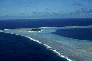
Faure Island is a 58 km2 island pastoral lease and nature reserve, east of the Francois Peron National Park on the Peron Peninsula, in Shark Bay, Western Australia. It lies in line with the Monkey Mia resort to the west, and the Wooramel River on the eastern shore of Shark Bay. It is surrounded by the Shark Bay Marine Park and Shark Bay World Heritage Site and, as the Faure Island Sanctuary, is owned and managed by the Australian Wildlife Conservancy (AWC).
Guano is the accumulated excrement of seabirds and bats. As a manure, guano is a highly effective fertilizer due to its exceptionally high content of nitrogen, phosphate, and potassium: key nutrients essential for plant growth. Guano was also, to a lesser extent, sought for the production of gunpowder and other explosive materials.

The Lacepede Islands, sometimes referred to simply as the Lacepedes, are a group of four islands lying off the Kimberley coast of Western Australia, about 120 kilometres north of Broome.

Useless Loop is a town located on the Heirisson Prong on Denham Sound in the Southern Region of UNESCO World Heritage Site Shark Bay, Western Australia. The town of Denham is on the opposite shore of the sound and the more famous Monkey Mia near Denham. Useless Loop is a closed company town, with 70 employees and their families servicing the Solar Salt Operation Shark Bay which was established in 1962 by Shark Bay Resources Ltd. A joint venture was formed in 1973 with Mitsui & Co. Ltd which acquired full ownership in 2005, incorporated as Shark Bay Salt Pty Ltd. In 2015, Useless Loop's salt exports were running at a rate of 1.4 million tonnes per annum.
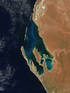
Peron Peninsula is a long narrow peninsula located in the Shark Bay World Heritage site in Western Australia, at about 25°51' S longitude and 113°30' E latitude. It is some 130 kilometres (81 mi) long, running north-northwesterly, located east of Henri Freycinet Harbour and west of Havre Hamelin and Faure Island. It is the largest of the Shark Bay peninsulas. Significant settlements include Denham and Monkey Mia. An airport is located there. It is the location of former Pastoral leases Peron and Nanga stations. It is the main location of land access to points within the World Heritage site. The northern area contains the Francois Peron National Park. It is surrounded by the Shark Bay Marine Park and its lower southeast part is adjacent to the Hamelin Pool Marine Nature Reserve.
Goulet Bluff is a point on the western side of the Peron Peninsula in the Shark Bay World Heritage Site that acts as an important marker between the Denham Sound or northern portion of the Western Gulf Zone from the southern fishing zone of Freycinet Estuary. A 1,400 metres (4,593 ft) beach is located to the north side of the bluff. Waves usually maintain a migrating spit at the southern end of the each forming a narrow lagoon. The area is located 36 kilometres (22 mi) south east of Denham and provides four campsites for visitors.
Henri Freycinet Harbour, also known as Freycinet Estuary, is one of the inner gulfs of Shark Bay, Western Australia, a World Heritage Site that lies to the west of the Peron Peninsula.

The Peron Islands are two low-lying islands off the west coast of the Northern Territory of Australia. They are about 5 km off Channel Point. Channel Point forms the northern end of Anson Bay which includes the mouth of the Daly River.

Castle Rock National Wildlife Refuge is 0.5 miles (0.80 km) offshore from Crescent City in northern California. This coastal rock covers approximately 14 acres (57,000 m2), and rises steeply 335 feet (102 m) above sea level. The refuge provides an important sanctuary for the Aleutian cackling goose and nesting seabirds.
Samson Gabriel Dyer aka Sampson Dyers was an African-American noted for his association with Dyer Island off the Cape Agulhas coast of South Africa.

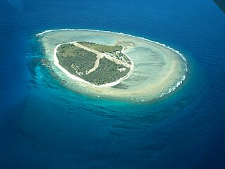
Freycinet Island is a small island in Henri Freycinet Harbour, lying off the Carrarang peninsula in the southern part of Shark Bay, on the-west coast of Western Australia. It is an elevated limestone plateau with scree slopes, vegetated with nitre bush shrubland.

From the late 1700s until the end of the 19th century, the British Empire established, expanded and maintained a number of colonies on the continent of Australia. These colonies included New South Wales, Van Diemen's Land, Western Australia, South Australia, Victoria and Queensland. Many of these were initially formed as penal settlements, and all were built on land occupied by Indigenous Australians. In order to keep the large number of transported convicts under control, enforce colonial law and fight the Australian frontier wars, British military elements, including the British Army, were deployed and garrisoned in Australia. From 1790 to 1870 over 30 different regiments of the British Army consisting of a combined total of around 20,000 soldiers were based in the Australian British colonies.
