RAF Oxenhope Moor

Last updated

RAF Oxenhope Moor
Yorkshire, England
RAF Oxenhope.jpg
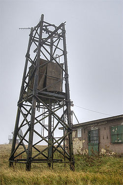
The remains of a communications mast at RAF Oxenhope.
West Yorkshire UK location map.svg
Red pog.svg
RAF Oxenhope Moor
Coordinates 53°47′29″N1°59′02″W / 53.7913°N 1.984°W / 53.7913; -1.984
Site information
Controlled by Royal Air Force
Conditiondemolished
Site history
In use1942–1970

RAF Oxenhope Moor was a British Second World War radio station, located on Cock Hill Moor near the village of Oxenhope in Yorkshire. [1] It was known by a number of different names, including Oxenhope Laboratory, Oxenhope Radar Station and Oxenhope Weather Station.

The station was built during the Second World War and was used as part of the GEE navigation system (started in March 1942) used to guide bombers to their targets in Europe. The station was maintained by the RAF as No. 585 Signals Unit until 1970, [2] and was then taken over by the University of Bradford. [3]

Notes and references

  1. Wood, Steven; Palmer, Ian (2009). Oxenhope & Stanbury through time. Stroud: Amberley. p. 49. ISBN   978-1848685239.
  2. "Gee Chain Closure". Flight International . Reed Business Information Ltd. 97 (3185): 536. 26 March 1970. Retrieved 1 January 2010.
  3. "Former RAF radar station to be bulldozed". Hebden Bridge Times. 16 October 2008. Retrieved 1 January 2010.

Related Research Articles

Radio navigation

Radio navigation or radionavigation is the application of radio frequencies to determine a position of an object on the Earth, either the vessel or an obstruction. Like radiolocation, it is a type of radiodetermination.

Gee (navigation)

Gee, sometimes written GEE, was a radio navigation system used by the Royal Air Force during World War II. It measured the time delay between two radio signals to produce a fix, with accuracy on the order of a few hundred metres at ranges up to about 350 miles (560 km). It was the first hyperbolic navigation system to be used operationally, entering service with RAF Bomber Command in 1942.

RAF Fylingdales Royal Air Force base in Yorkshire, England

Royal Air Force Fylingdales or more simply RAF Fylingdales is a Royal Air Force station on Snod Hill in the North York Moors, England. Its motto is "Vigilamus". It is a radar base and is also part of the Ballistic Missile Early Warning System (BMEWS). As part of intelligence-sharing arrangements between the United States and United Kingdom, data collected at RAF Fylingdales are shared between the two countries. Its primary purpose is to give the British and US governments warning of an impending ballistic missile attack. A secondary role is the detection and tracking of orbiting objects; Fylingdales is part of the United States Space Surveillance Network. As well as its early-warning and space-tracking roles, Fylingdales has a third function – the Satellite Warning Service for the UK. It keeps track of spy satellites used by other countries, so that secret activities in the UK can be carried out when they are not overhead. The armed services, defence manufacturers and research organisations, including universities, take advantage of this facility.

RAF Neatishead Operational radar base of the Royal Air Force in Norfolk, England

Remote Radar Head Neatishead or RRH Neatishead is an air defence radar station operated by the Royal Air Force. It is located approximately 11 kilometres (6.8 mi) north east of Norwich in Norfolk, England.

Oboe (navigation)

Oboe was a British aerial blind bombing system in World War II, based on radio transponder technology. The system consisted of a pair of radio transmitters on the ground, which sent signals which were received and retransmitted by a transponder in the aircraft. By comparing the time each signal took to reach the aircraft, the distance between the aircraft and the station could be determined. The Oboe operators then sent radio signals to the aircraft to bring them onto their target and properly time the release of their bombs.

Gee-H, sometimes written G-H or GEE-H, was a radio navigation system developed by Britain during World War II to aid RAF Bomber Command. The name refers to the system's use of the earlier Gee equipment, as well as its use of the "H principle" or "twin-range principle" of location determination. Its official name was AMES Type 100.

RAF Stenigot

RAF Stenigot is a former Second World War radar station situated at Stenigot, near Donington on Bain, Lincolnshire.

Skewjack

Skewjack is the name of a plot of land in west Cornwall, England, United Kingdom. It is situated about 1.5 miles (2 km) east of Land's End on the B3315 road. It was the site of RAF Sennen, and is now the site of a Fibre-optic Link Around the Globe building.

RRH Portreath

Remote Radar Head Portreath or RRH Portreath is an air defence radar station operated by the Royal Air Force. It has a coastal location at Nancekuke Common, approximately 1.25 kilometres (0.78 mi) north east of the village of Portreath in Cornwall, England.

RAF Lindholme Royal Air Force base in Yorkshire, England

Royal Air Force Station Lindholme or more simply RAF Lindholme is a former Royal Air Force station in South Yorkshire, England. It was located 3.9 miles (6.3 km) south of Thorne and 6.9 miles (11.1 km) north east of Doncaster and was initially called RAF Hatfield Woodhouse.

RAF Bempton Royal Air Force base in Yorkshire, England

Royal Air Force Bempton or more simply RAF Bempton is a former Royal Air Force station situated at Bempton in the East Riding of Yorkshire, England, 6 miles (10 km) north of Bridlington. During the Second World War it was established as a radar station, becoming part of the Chain Home Low (CHL) network.

RAF Marston Moor Royal Air Force base in Yorkshire, England

RAF Marston Moor was a Royal Air Force airfield at Tockwith, North Yorkshire, during the Second World War. It was originally called RAF Tockwith, but confusion with RAF Topcliffe led to the name change.

No. 115 Squadron RAF Flying squadron of the Royal Air Force

Number 115 Squadron is a Royal Air Force squadron operating the Grob Tutor T1, training QFIs for the RAF's Elementary Flying Training (EFT) squadrons and the University Air Squadrons, as well as undertaking evaluation and standardisation duties.

RAF Danby Beacon Royal Air Force base in Yorkshire, England

Royal Air Force Danby Beacon or more simply RAF Danby Beacon was an early warning radar Royal Air Force station that formed part of the Chain Home network of radar stations built by the Royal Air Force immediately prior to the Second World War.

RAF Holme-on-Spalding Moor Royal Air Force base in Yorkshire, England

RAF Holme-on-Spalding Moor, or more simply RAF Holme is a former Royal Air Force station located in the East Riding of Yorkshire, England.

RAF Hunmanby Moor Former Royal Air Force training camp in Yorkshire, England

RAF Hunmanby Moor,, was a Royal Air Force training camp during the Second World War in Hunmanby, East Riding of Yorkshire, England. The site was commandeered at the outbreak of war and returned to civilian use as a holiday camp in 1945. From 1942, many RAF Regiment training courses were run at the site.

RAF Kidbrooke

RAF Kidbrooke was a Royal Air Force base, situated in Kidbrooke in south-east London, in the Royal Borough of Greenwich. The site was operational from 1917 to 1965 and was mainly used as a stores, maintenance and training facility.

RAF Shipton Former Royal Air Force base in Yorkshire, England

Royal Air Force Shipton, was a First World War era airfield located north of the village of Shipton-by-Beningbrough, in North Yorkshire, England. During the First World War, it was used by No. 76 Squadron RAF whose remit was to provide Home Defence (HD).