
Leeds East Airport Church Fenton, formerly RAF Church Fenton, is an airport and former Royal Air Force station located 4.3 miles (6.9 km) south-east of Tadcaster, North Yorkshire, England and 6.3 miles (10.1 km) north-west of Selby, North Yorkshire, near the village of Church Fenton. The airport has had a licensing application from the UK Civil Aviation Authority rejected. This led to the scrapping of plans to allow regular scheduled passenger flights and charter flights to various European destinations. The airport has subsequently been awarded an operating licence for private use.
Royal Air Force Manston or more simply RAF Manston is a former Royal Air Force station located in the north-east of Kent, at grid reference TR334663 on the Isle of Thanet from 1916 until 1996. The site was split between a commercial airport Kent International Airport (KIA), since closed, and a continuing military use by the Defence Fire Training and Development Centre (DFTDC), following on from a long-standing training facility for RAF firefighters at the RAF Manston base.

Leeds Bradford Airport is located in Yeadon, in the City of Leeds Metropolitan District in West Yorkshire, England, about 7 miles (11 km) northwest of Leeds city centre, and about 9 miles (14 km) northeast from Bradford city centre. It serves Leeds and Bradford and the wider Yorkshire region including York, Wakefield and Harrogate, and is the largest airport in Yorkshire. The airport was in public ownership until May 2007, when it was bought by Bridgepoint Capital for £145.5 million. Bridgepoint sold it in 2017 to AMP Capital.
Royal Air Force Warmwell or more simply RAF Warmwell is a former Royal Air Force station near Warmwell in Dorset, England from 1937 to 1946, located about 5 miles east-southeast of Dorchester; 100 miles southwest of London.

Royal Air Force Detling, or more simply RAF Detling, is a former Royal Air Force station situated 600 feet (180 m) above sea level, located near Detling, a village about 4 miles (6.4 km) miles north-east of Maidstone, Kent.

Royal Air Force Wrexham, or more simply RAF Wrexham, is a former Royal Air Force station at Borras, on the outskirts of Wrexham, Wales and north-east of the city centre.

Royal Air Force Melbourne or more simply RAF Melbourne is a former Royal Air Force station located near Melbourne, East Riding of Yorkshire, England.
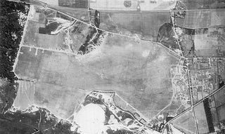
Royal Air Force Doncaster or more simply RAF Doncaster, also referred to as Doncaster Aerodrome, is a former Royal Air Force station near Doncaster, South Yorkshire, England.

Royal Air Force Harlaxton or more simply RAF Harlaxton is a former Royal Air Force satellite station near the village of Harlaxton, 3 mi (4.8 km) south west of Grantham, Lincolnshire, England. The airfield was located in a triangle of flat fields midway between Harlaxton Manor and the nearby village of Stroxton.

Royal Air Force Anwick or more simply RAF Anwick is a former Second World War faux Royal Air Force decoy station near the village of Anwick, 21.3 mi (34.3 km) south east of the county town of Lincoln, Lincolnshire, England. The airfield was located in a field three quarters of a mile north-north-west of Anwick village.

Hounslow Heath Aerodrome was a grass airfield, operational 1914–1920. It was in the London borough of Hounslow, and hosted the British Empire's first scheduled daily international commercial flights, in 1919. The site today includes the main remaining part of Hounslow Heath.

Royal Air Force Church Fenton or RAF Church Fenton is a former Royal Air Force (RAF) station located 4.3 miles (6.9 km) south-east of Tadcaster, North Yorkshire, England and 6.3 miles (10.1 km) north-west of Selby, North Yorkshire, near the village of Church Fenton.

RNAS Hornsea Mere,, was a Royal Naval Air Service seaplane base located on Hornsea Mere, in the East Riding of Yorkshire, England. The mere was used for seaplanes because it was close to the sea and because its still water made it easier to launch the planes. Initially used as a relief site, the base became a full station in 1918, and was vacated in 1919. Many of the original buildings and earthworks survive.

The Yorkshire Universities Air Squadron is a Royal Air Force flying training unit that currently operates out of RAF Leeming in North Yorkshire, England. One of fourteen University Air Squadrons, the unit traditionally recruits students from universities across the Yorkshire and Humber region and provides bursaries for those who wish to pursue a career in the Royal Air Force.

Royal Air Force Ripon was a First World War airfield maintained by the Royal Flying Corps in the city of Ripon, North Yorkshire, England. The airfield was home to No. 76 Squadron which was employed on Home Defence (HD) in the United Kingdom. The airfield was created when the Royal Flying Corps (RFC) commandeered the southern half of Ripon Racecourse in 1916. After the end of the First World War, the airfield was returned to horse-racing.

Marske Aerodrome was a First World War-era airfield used by the Royal Flying Corps, and later by the Royal Air Force, between 1917 and 1920. The aerodrome was just to the west of the village of Marske-by-the-Sea in Yorkshire, England. Marske aerodrome hosted air gunnery schools and trained pilots in tactics and methods of aerial combat so that they could be deployed to the front. Marske is known for being the aerodrome where W. E. Johns, author of the Biggles books, undertook his training, as well as being noted for some of the flying instructors who were famous among the aircrew cadre.

Bramham Moor Aerodrome,, was a First World War era military airfield near to the village of Bramham, West Yorkshire, England. Initially a Royal Flying Corps site, on the formation of the RAF, its name was officially changed to RAF Tadcaster, however, the unit was still referred to as Bramham, or Bramham Moor, even in official documents. The base was used between March 1916 and December 1919 by active aircraft squadrons, but was not closed down until April 1920. Bramham was originally used as a Home Defence station, due to the threat of Zeppelin attacks, but later, it was used primarily for preparing aircrew for front line operations. It did not see re-use as an airfield during the Second World War, however, vehicles were parked on the grassed runway areas to deter glider landings during the threat of invasion.

Redcar Aerodrome is a former First World War airfield located in Redcar, North Yorkshire, England. The site hosted an elementary flying school for newly entered pilots into the Royal Naval Air Service, though some offensive and defensive operations were flown from Redcar as well. The base was created as part of chain of new air stations after the German naval bombardment of east coast towns in December 1914. The base had a brief operational lifespan between July 1915 and December 1919, after which it was decided not to retain Redcar as an active station, and much of the site has been re-used for housing.

Beverley Aerodrome, was a First World War era Royal Flying Corps training depot, in Bishop Burton, East Riding of Yorkshire, England. The site, like many others in Yorkshire, was developed from a racecourse on the western edge of Beverley, along the road between Beverley and York. Initially set up as a location for squadrons employed in Home Defence (HD), particularly preventing Zeppelin attacks on Hull and the east coast, the site later became a training depot for squadrons and flights who would then deploy to the front line. Beverley was also used as a standing up and transfer location for six Canadian Reserve Squadrons in 1917, all of which were posted to Canada. Beverley Aerodrome was used between 1916 and 1920, with the RAF later using the site in the 1930s in a non-flying role.
Royal Air Force Bellasize, also known as RAF Bellasize, was a former RAF airfield in the hamlet of Bellasize, near Gilberdyke, East Riding of Yorkshire, England. Originally opened in 1916, Bellasize was one of only four Yorkshire-based RAF locations to see use in the First and Second World Wars. Flying at Bellasize was sporadic and training based, with the site not being used in an offensive capacity during the Second World War.


