Ragged Ass Road (street)

Last updated
Ragged Ass Road
Ragged Ass Road blade sign, Yellowknife, NT.jpg
Looking north along Ragged Ass Road, Yellowknife, NT.jpg
View north from Brock Drive, 2015
Former name(s)Privy Road
NamesakePoverty experienced by local prospectors
Type Dirt road
Maintained byCity of Yellowknife
Length150 m (490 ft)
Addresses3902–3920
Location Yellowknife, NT, Canada
Postal code X1A 2T4 [1]
Coordinates 62°27′38″N114°21′09″W / 62.46063°N 114.35256°W / 62.46063; -114.35256 Coordinates: 62°27′38″N114°21′09″W / 62.46063°N 114.35256°W / 62.46063; -114.35256
South endBrock Drive
North endHamilton Drive
Other
Known forUnique name

Ragged Ass Road is a short unpaved residential street in the Old Town section of Yellowknife, Northwest Territories, Canada. Its name started as a joke in 1970 by resident Lou Rocher, who owned much of the property along it at the time, and his friends. At the time the street had been known as "Privy Road" due to the large number of outhouses along it. When a difficult prospecting season yielded little income, convincing residents that they were "ragged ass broke", they decided that that should be the name of the street.

Contents

While widely used, the name was somewhat controversial. It was not officially recognized by the city with signposts until the mid-2010s, after Rocher's death. [2] It has been described as one of the most famous streets in Canada. Singer Tom Cochrane named his 1995 album after it, including a song about the street.

Street

Ragged Ass Road is in a residential area midway between the intersection of Franklin (50th) Avenue, Yellowknife's main street, and School Draw Avenue, its lake shore road, and Yellowknife Bay on the north arm of Great Slave Lake. [3] The terrain is flat, at approximately 160 metres (520 ft) in elevation, reflecting the proximity of the lake. [4] The neighborhood is at the south end of the city's Old Town, [5] [6] on a peninsula projecting into the lake's Yellowknife Bay. [4]

The southern terminus is at Brock Drive, three blocks east of School Draw. From there it follows a north-northeast heading, bending more to the northeast midway along its 150-metre (490 ft) length, then back to its original heading as it reaches its north terminus at Hamilton Drive. Along with its neighboring streets it is unpaved for its entire length. [3]

With the exception of one large bedrock outcrop in the middle of the west side of the street, all the lots along the street are developed with wood frame residences of modern construction and associated outbuildings. Some small deciduous trees grow among them. [7] (In her novel Bones Are Forever , American writer Kathy Reichs described the prevailing architectural style of Ragged Ass as "northern hodgepodge". [8] ) Addresses are in the range of 3901–3921, following Yellowknife's grid-based numbering system. Its postal code X1A 2T4. [1]

History

The construction date of Ragged Ass Road is unknown. Yellowknife was significantly settled only after a 1935 gold rush. After a few years, development was interrupted by World War II, only to resume afterwards. At that time most development was on the peninsula, in the area known today as Old Town. The road may have started as a narrow alley where residents cut wood to building the barges that carried freight to and from the growing settlement across Great Slave Lake. [9] By 1957, when Saskatchewan native Lou Rocher settled in the area, [2] it existed and was known unofficially as Privy Road due to the many outhouses along it. [5]

Rocher made his living through several vocations, selling firewood, commercial fishing, but primarily prospecting. He eventually came to live on Privy Road, where he owned several lots on the street. On them he built homes and cabins, often letting people in need live there. [2]

One night near the end of 1970, in which he and fellow prospectors had worked hard but found far less, he was drinking with some of them in the family Quonset hut. Reflecting on their circumstances, Rocher joked that the street should be named "Ragged Ass Road" since they were all "ragged ass broke". [My father] felt he should be able to name it because he owned six of the nine lots on the road and he thought he could name it appropriately", his son recalled later. The men put up a sign that night. [2] [10] The term's use as a place name might not have been original. There was reportedly a Ragged Ass Mine on the lake in earlier years. [11]

The name caught on, if not formally. Officially the city still considered the street to have no name, but Rocher made his own signs, replacing them after visiting tourists stole them. Eventually they were welded to their posts, and gift shops in the city started selling replicas. [5] During the 1980s, Rocher clashed with Yellowknife's municipal government over a survey of the area. At one point he even blocked the street off to keep city employees away. [2]

In 1995 former Red Rider lead singer Tom Cochrane named his third album Ragged Ass Road after the street. The title track of the album described a place "Where the shore fires burn out on a new frontier" and had the chorus "Oh did you find the midnight sun" [upper-alpha 1] Down on Ragged Ass Road". [12] It added to the road's allure as a tourist attraction, but the city still demurred from making the name official. [2]

The city was not unique in its reluctance to embrace the name despite its popularity. In 2004, a small town in the U.S. state of Ohio mailed a Ragged Ass Road sign back to Yellowknife's city government after having confiscated it from a homeowner as inappropriate for public display. Eight years later a British Columbia man flying out of Vancouver on WestJet with a Ragged Ass Road T-shirt was told by a flight attendant to either cover it up or turn it inside out for the duration of the flight since the airline was "family-friendly". He chose the former option, but when the incident made national news, WestJet apologized. When it did so, it posted to its Instagram account a photo of a Ragged Ass Road sign that had been on the office wall of its chief executive officer, Gregg Saretsky, for two years. Yellowknife city officials made it a point to meet with WestJet officials to come to a common understanding: the T-shirts are a tourist draw. [2] [9] [13]

The year before, crime novelist and forensic anthropologist Kathy Reichs, a producer of the American television series Bones , had attended the NorthWords literary festival in Yellowknife. She liked the city so much she set part of her next novel, Bones Are Forever , there. [14] [15] In one scene her main character, Temperance Brennan, a forensic anthropologist like her creator, trails a suspect from downtown Yellowknife to Ragged Ass Road on a cold morning, giving her a chance to describe it:

A sign on a rock said Ragged Ass Road. That's one you'd never see on the Queen City [upper-alpha 2] map ... The neighborhood was residential, with browned-out grass hugging up to the road and utility wires hanging low overhead. I smelled fishy water and bracken mud and sensed a lake nearby ...The newer homes looked like they'd been assembled from mail-order kits. Aluminum siding. Prefab windows. Faux-colonial shutters and doors ... The older ones resembled cottages at a hippie summer camp. Unstained frame exteriors painted with murals or images taken from nature. Metal downspouts and smokestacks. Whirligigs, plastic animals, and ceramic gnomes in the yards or topping the fences ... Every house had at least one outbuilding, a rusted tank, and a mound of firewood. [16]

According to Murtaza Haider, professor and director of Toronto Metropolitan University's Institute of Housing and Mobility, it is claimed that this street is an example of a "poorly named street ... [that] create[s] negative shift in market value." [upper-alpha 3]

"Ragged Ass" street sign replicas are sold in the area. Nevertheless, the signs have been stolen so frequently that the city has had them welded to their posts. [18] [19]

Lou Rocher died in May 2013 and was remembered around Yellowknife most prominently for giving Ragged Ass Road its name. Despite that, his family noted, at that time the city still had not installed official street signs with the name. [2] As of 2015, there are city signs at both ends of the road.

See also

Notes

  1. While the midnight sun is often associated with Yellowknife, it is south of the Arctic Circle and only experiences white nights, where the sun dips just below the horizon for a few hours of twilight in the summertime, rather than the full midnight sun.
  2. A reference to the American city of Charlotte, North Carolina, where Brennan, like Reichs, lives for part of the year. A few paragraphs before this, Brennan had noted how 50th Avenue's apparent sudden change of name to Franklin Avenue north of downtown Yellowknife was a phenomenon she was used to from Charlotte's streets.
  3. "Residents of Canada's Dingle Bingle Hill Terrace, Cheapside Street, Ragged Ass Road and Bastard Ward consider yourselves warned: There is a small but noteworthy negative effect between a badly named street and the perceived market value of homes or businesses that reside on it ..." Conversely, a well-regarded street name, e.g. Bloor Street in Toronto, Ontario, Canada, can have a measurable positive effect on perceived value and price. [17]

Related Research Articles

<span class="mw-page-title-main">Northwest Territories</span> Territory of Canada

The Northwest Territories is a federal territory of Canada. At a land area of approximately 1,144,000 km2 (442,000 sq mi) and a 2016 census population of 41,790, it is the second-largest and the most populous of the three territories in Northern Canada. Its estimated population as of 2022 is 45,605. Yellowknife is the capital, most populous community, and only city in the territory; its population was 19,569 as of the 2016 census. It became the territorial capital in 1967, following recommendations by the Carrothers Commission.

<span class="mw-page-title-main">Yellowknife</span> Capital city of the Northwest Territories, Canada

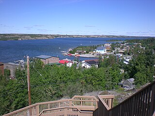
Yellowknife is the capital, largest community, and only city in the Northwest Territories, Canada. It is on the northern shore of Great Slave Lake, about 400 km (250 mi) south of the Arctic Circle, on the west side of Yellowknife Bay near the outlet of the Yellowknife River.

<i>Ragged Ass Road</i> 1995 studio album by Tom Cochrane

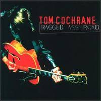
Ragged Ass Road is the third solo studio album by Red Rider frontman Tom Cochrane, released in October 1995. The album was named for Ragged Ass Road, a street in Yellowknife, Northwest Territories. Songs from the album include "I Wish You Well", which became the first Canadian song to debut at #1 on the RPM Canadian Singles Charts, as well as three other Top 20 hits in Canada: "Wildest Dreams", "Dreamer's Dream" and "Crawl". Ragged Ass Road earned two Juno award nominations and achieved Platinum sales status in Canada. The album was produced by Cochrane and John Webster at Metalworks Studios and Ragged Ass Road Studios.

<span class="mw-page-title-main">Great Slave Lake</span> Second-largest lake in the Northwest Territories, Canada

Great Slave Lake, known traditionally as Tıdeè in Tłı̨chǫ Yatıì (Dogrib), Tinde’e in Wıìlıìdeh Yatii / Tetsǫ́t’ıné Yatıé, Tu Nedhé in Dëne Sųłıné Yatıé (Chipewyan), and Tucho in Dehcho Dene Zhatıé (Slavey), is the second-largest lake in the Northwest Territories of Canada, the deepest lake in North America at 614 m (2,014 ft), and the tenth-largest lake in the world by area. It is 469 km (291 mi) long and 20 to 203 km wide. It covers an area of 27,200 km2 (10,500 sq mi) in the southern part of the territory. Its given volume ranges from 1,070 km3 (260 cu mi) to 1,580 km3 (380 cu mi) and up to 2,088 km3 (501 cu mi) making it the 10th or 12th largest by volume.

<span class="mw-page-title-main">Street sign theft</span> Illegal removal of street signs

Street sign theft occurs when street signs are stolen, to be used as decorations, sold as scrap metal or to avoid obeying the law by claiming later the sign was not there. Although the theft often seems arbitrary, signs with unusual or amusing names tend to be stolen more frequently. Sometimes considered to be a prank by the perpetrators, the theft is often costly and inconvenient for the municipality or agency that owns the sign. In the United States, each street sign generally costs between $100 and $500 to replace.

<span class="mw-page-title-main">Kathy Reichs</span> American writer and forensic anthropologist

Kathleen Joan Reichs is an American crime writer, forensic anthropologist and academic. She is an adjunct professor of anthropology at the University of North Carolina at Charlotte.

<span class="mw-page-title-main">New York State Route 199</span> New York state highway in Ulster and Dutchess counties

New York State Route 199 is a 30.91-mile-long (49.74 km) state highway located in the Hudson Valley of the U.S. state of New York. Its western end is in Ulster County, where it begins as the continuation of the short U.S. Route 209 expressway east of its interchange with U.S. Route 9W; after crossing the Kingston–Rhinecliff Bridge over the Hudson River the rest of the highway crosses northern Dutchess County. As it does it passes through downtown Red Hook and Pine Plains, reaching its eastern end at U.S. Route 44 and State Route 22 southwest of Millerton in the upper Harlem Valley.

<span class="mw-page-title-main">Colorado State Highway 82</span> 85-mile road across mountains from Leadville through Aspen to Glenwood Springs

State Highway 82 is an 85.3-mile-long (137.3 km) state highway in the U.S. state of Colorado. Its western half provides the principal transportation artery of the Roaring Fork Valley on the Colorado Western Slope, beginning at Interstate 70 (I-70) and U.S. Highway 6 in Glenwood Springs southeast past Carbondale, Basalt and Aspen. From there it continues up the valley to cross the Continental Divide at Independence Pass. On the Eastern Slope, it follows Lake Creek past some of Colorado's highest mountains to Twin Lakes Reservoir, where it ends at US 24 south of Leadville.

<span class="mw-page-title-main">Alberta Highway 1A</span> Designation for two disconnected sections of provincial highway in Alberta, Canada

Alberta Provincial Highway No. 1A is the designation of two alternate routes off the Alberta portion of Trans-Canada Highway 1. However, it is not the only name used for spurs off Highway 1 - Highway 1X is another such designation. Despite these highways being suffixed routes of Highway 1, they are not part of the Trans-Canada Highway network, and are signed with Alberta's provincial primary highway shields instead of the Trans-Canada shields used for Highway 1.

<span class="mw-page-title-main">The Gold Range</span>

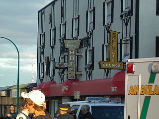
The Gold Range is a Canadian hotel and bar located in Yellowknife, Northwest Territories.

<span class="mw-page-title-main">Yellowknives</span> Indigenous peoples of the Northwest Territories, Canada

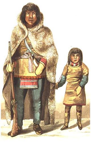
The Yellowknives, Yellow Knives, Copper Indians, Red Knives or T'atsaot'ine are indigenous peoples of Canada, one of the five main groups of the First Nations Dene who live in the Northwest Territories of Canada. The name, which is also the source for the later community of Yellowknife, derives from the colour of the tools made from copper deposits.

<span class="mw-page-title-main">New York State Route 52</span> East-west route from Narrowsburg to Carmel

New York State Route 52 (NY 52) is a 108.72-mile-long (174.97 km) state highway in the southeastern part of the state. It generally runs from west to east through five counties, beginning at the Pennsylvania state line in the Delaware River near Narrowsburg, crossing the Hudson River on the Newburgh–Beacon Bridge, and ending in Carmel. NY 52 and NY 55, both major east–west routes of the Mid-Hudson Region, run parallel to each other, intersecting in downtown Liberty.

The Amazing Race Canada 1 is the first season of The Amazing Race Canada, a reality game show based on the American series The Amazing Race. It features nine teams of two with pre-existing relationships who raced around Canada and is hosted by Canadian Olympian Jon Montgomery. The grand prize includes a CA$250,000 cash payout, two Chevrolet Corvette Stingrays and unlimited air travel for a year with Air Canada. The show was produced by Insight Productions, in association with Bell Media and was broadcast on CTV.

<span class="mw-page-title-main">Fireweed Studio</span>

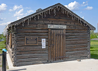
The Fireweed Studio is a log cabin in Yellowknife, Northwest Territories, Canada, located in Somba K'e Park near City Hall. It was built in the late 1930s to house explosives at what later became Giant Mine, and later moved to its present location. In 1996 it was listed on the Canadian Register of Historic Places; two years later it was designated a city Heritage Building for its status as a well-preserved remnant of the city's early years.

<span class="mw-page-title-main">Yellowknife Post Office</span> Building in Northwest Territories, Canada

The Post Office building for Yellowknife, Northwest Territories, Canada, serving the X1A postal codes, is located at the southwest corner of 49th Street and Franklin (50th) Avenue. It is a two-storey concrete building in a late modernist style dating to the mid-20th century. In 2006 it was designated a City of Yellowknife Heritage Site in recognition of its long standing role as a social centrepiece for the downtown community; it has been administratively listed on the Canadian Register of Historic Places as a result. "This is where you went to find everybody" in the 1960s, one city councillor recalled when the building received its heritage plaque in 2010.

<span class="mw-page-title-main">Log School House</span>

The first building used as a school in Yellowknife, Northwest Territories, Canada, is currently located on Franklin (50th) Avenue at the south end of New Town, the city's downtown section. It is a small log cabin dating to the mid-1930s. It was designated a City of Yellowknife Heritage Site in 1998, and listed on the Canadian Register of Historic Places in 2004.

<span class="mw-page-title-main">Greenstone Building</span> Main office of Canadian federal government in Yellowknife, capital of the Northwest Territories

The Greenstone Building, officially the Greenstone Government of Canada Building, and sometimes known as the Greenstone Government Building, is located on Franklin (50th) Avenue in downtown Yellowknife, Northwest Territories, Canada. It is a four-storey building faced in stone, completed and opened in 2005. Within are the local offices of 16 federal government agencies. Prior to the building's construction they were scattered in different buildings around the city.

<span class="mw-page-title-main">Death of Atsumi Yoshikubo</span> Japanese woman found in wilderness of Canadian North

Around midday on October 22, 2014, a passing motorist saw an Asian woman walking north along the Ingraham Trail on the outskirts of Yellowknife in the Northwest Territories, Canada. Several days later, after seeing stories in the local media that 45-year old Atsumi Yoshikubo (吉窪昌美) who had been visiting the city from her home in southern Japan, had gone missing, she reported the sighting. It was the last time she was seen alive.

<span class="mw-page-title-main">Frame Lake</span> Body of water

Frame Lake is located in Yellowknife, Northwest Territories, Canada. It is an 84-hectare (210-acre) endorheic freshwater body located between the city's downtown section and a larger residential area. The Frame Lake Trail circles it, and city hall and the territorial legislative assembly building are on its shores.

<span class="mw-page-title-main">Explorer Hotel</span> Prominent hotel in Yellowknife, Canada

The Explorer Hotel is located on 49th Avenue in Yellowknife, Northwest Territories, Canada. It is an eight-storey-tall modernist concrete structure built in the mid-1970s. Located on a high outcrop of ground overlooking downtown, it is one of the tallest buildings in the city, and claims to be the largest hotel in Northern Canada; it has also been described as the city's best and grandest. It is owned and operated by Nunastar Properties.

References

  1. 1 2 "3902 – 3920 Ragged Ass RD, Yellowknife – Postal Code". canadapostalcodes.net. 2015. Retrieved September 19, 2015.
  2. 1 2 3 4 5 6 7 8 Whitehouse, Simon (May 3, 2013). "Ragged Ass Road pioneer remembered". Northern News Services . Retrieved March 8, 2015.
  3. 1 2 ACME Mapper (Map). Cartography by Google Maps. ACME Laboratories. Retrieved September 19, 2015.
  4. 1 2 Atlas of Canada Toporama (Map). 1:6,000. Cartography by Natural Resources Canada. Government of Canada . Retrieved September 19, 2015.
  5. Wilkinson, Tandi (September 28, 2012). "Ragged Ass Road, Dog Island Film Festival, and Other Interesting Things About Life in Yellowknife". The Song I Live By. Retrieved November 7, 2015.
  6. Per the Google Street View option at the ACME Mapper link given above.
  7. Reichs 2013, pp.  168–170.
  8. 1 2 Hudson, Katherine (October 17, 2012). "Ragged Ass Road gets a rough ride". Northern News Services . Retrieved September 19, 2015.
  9. Heal, Tyler (2007). The Times Behind the Signs: The History Behind Yellowknife's Street Names. Yellowknife: Crescent Publishing. ISBN   978-0-9739420-0-2.
  10. Malcolm, David (October 18, 2011). "Letter from Canada: Yellowknife, gateway to the Arctic". The Guardian . Retrieved September 19, 2015.
  11. "Tom Cochrane – Ragged Ass Road lyrics". Lyrics Mine. Retrieved September 19, 2015.
  12. "WestJet apologizes after Ragged Ass Road shirt flap". CBC . October 16, 2012. Retrieved September 19, 2015.
  13. Reichs 2013, pp.  369.
  14. Reichs, Kathy. "Meet the Brains Behind 'Bones'". Talk of the Nation Science Friday (Interview). Interviewed by Ira Flatow. National Public Radio . Retrieved September 20, 2015.
  15. Reichs 2013.
  16. "Poorly named streets create negative shift in market value, real estate expert finds". CanWest MediaWorks Publications Inc. Retrieved November 5, 2015.
  17. Zahir, Fazile (February 4, 2008). "Kebabble: Turkey's costly signs of the times". Asia Times Online. Fethiye, Turkey. Archived from the original on May 14, 2008. Retrieved November 7, 2015.{{cite news}}: CS1 maint: unfit URL (link)
  18. "N.W.T. licence plate theft riles Vancouver cafe owners - North - CBC News". Cbc.ca. 2015-12-22. Retrieved 2016-09-18.

Further reading