Kalaburagi, formerly known as Gulbarga, is a city in the Indian state of Karnataka. It is the administrative headquarters of the Kalaburagi district and is the largest city in the region of North Karnataka (Kalyana-Karnataka). Kalaburagi is 568 km north of the state capital city of Bangalore. It was incorporated into the newly formed Mysore State through the States Reorganisation Act in 1956.

The Raichur Doab is a Doab, in this case the triangular region of land in the southern Indian states of Telangana and Karnataka lying between the Krishna River and its tributary, the Tungabhadra River. The doab is named for the town of Raichur in the Raichur District. The Raichur Doab is considered to be very fertile because of the sediments carried by Krishna and Tungabhadra rivers. The doab includes Raichur district and Koppal district in Karnataka, and Gadwal district in Telangana. Some areas of Raichur doab also called as Nadigadda region became a part of Telangana during Andhra Pradesh Reorganisation Act in 2014.Those areas are Gadwal, Alampur and Maganoor. Gadwal is one of the 31 districts of Telangana State.

Raichur District is an administrative district in the Indian state of Karnataka. It is located in the northeast part of the state and is bounded by Yadgir district in the north, Bijapur and Bagalkot district in the northwest, Koppal district in the west, Bellary district in the south, Jogulamba Gadwal district of Telangana and Kurnool district of Andhra Pradesh in the east.

Kalaburagi district, formerly known as Gulbarga district, is one of the 31 districts of Karnataka state in southern India. Kalaburagi city is the administrative headquarters of the district. The district is the headquarters of Kalaburagi division.

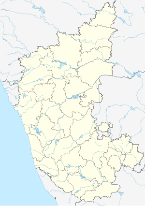
North Karnataka is a geographical region in Deccan plateau from 300 to 730 metres elevation that constitutes the region of the Karnataka state in India and the region consists of 13 districts. It is drained by the Krishna River and its tributaries the Bhima, Ghataprabha, Malaprabha, and Tungabhadra. North Karnataka lies within the Deccan thorn scrub forests ecoregion, which extends north into eastern Maharashtra.
Raichur is a city and City Corporation in the district of Raichur in the Indian state of Karnataka. Raichur, located between Krishna and Tungabhadra rivers, is the headquarters of Raichur district. It is located 410 km from the state capital, Bangalore.
Gandikota is a village and historical fort on the right bank of the Penna river, 15 km from Jammalamadugu in Kadapa district, Andhra Pradesh, India. The fort was the centre of power for various dynasties, such as the Kalyani Chalukyas, Pemmasani Nayakas, and the Golconda Sultanate. A sand fort was constructed by Kaka Raja, Vassals of Kalyani Chalukya rulers. Various additions of Islamic architecture were made during subsequent Muslim rule. The fort is a centrally protected monument of Archaeological Survey of India (ASI).
Mudgal is a Municipal town in Lingsugur taluk, Raichur district in the Indian state of Karnataka. Mudgal is about 10 miles south-west of Lingsugur.

The History of Karnataka goes back several millennia. Several great empires and dynasties have ruled over Karnataka and have contributed greatly to the history, culture and development of Karnataka as well as the entire Indian subcontinent. The Chindaka Nagas of central India Gangas, Rashtrakutas of Manyakheta, Chalukyas of Vengi, Yadava Dynasty of Devagiri were all of Kannada origin who later took to encouraging local languages.

The Battle of Raichur was fought between the Vijayanagara Empire and the Sultanate of Bijapur in 1520 in the town of Raichur, India. It resulted in a decisive victory for Vijayanagara forces, and the Bijapur ruler was defeated and pushed across the river Krishna.

The recorded history of Andhra Pradesh, one of the 28 states of 21st-century India, begins in the Vedic period. It is mentioned in Sanskrit epics such as the Aitareya Brahmana. Its sixth-century BCE incarnation Assaka lay between the Godavari and Krishna Rivers, one of sixteen mahajanapadas. The Satavahanas succeeded them, built Amaravati, and reached a zenith under Gautamiputra Satakarni.
The political history of medieval Karnataka spans the 4th to the 16th centuries in Karnataka region of India. The medieval era spans several periods of time from the earliest native kingdoms and imperialism; the successful domination of the Gangetic plains in northern India and rivalry with the empires of Tamilakam over the Vengi region; and the domination of the southern Deccan and consolidation against Muslim invasion. The origins of the rise of the Karnataka region as an independent power date back to the fourth-century birth of the Kadamba Dynasty of Banavasi which was the earliest of the native rulers to conduct administration in the native language of Kannada in addition to the official Sanskrit.
Bidar Fort is located in old city area, Bidar, Karnataka, India. The fort, the city and the district are all affixed with the name Bidar. Sultan Ahmad Shah I of the Bahmanid dynasty shifted his capital from Gulbarga to Bidar in 1427 and built his fort along with a number of Islamic monuments. There are over 30 monuments inside Bidar fort.
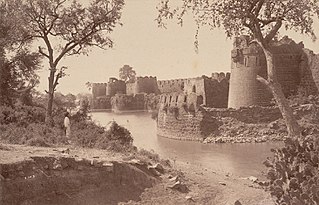
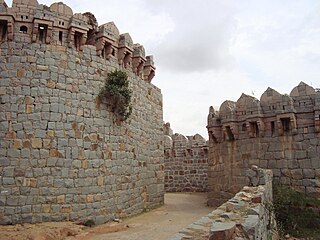
The Gulbarga Fort is located in Kalaburagi in the Kalaburagi district of North Karnataka. This fort was originally constructed by a hindu king Raja Gulchand, but it was subsequently significantly enlarged in 1347 by Al-ud-din Hasan Bahmani of the Bahmani Dynasty after he cut off his ties with the Delhi Sultanate; Islamic monuments such as mosques, palaces, tombs, and other structures were also built later within the refurbished fort. The Jama Masjid, built later within the fort in 1367, is a unique structure built in Persian architectural style, fully enclosed, with elegant domes and arched columns, unlike any other mosque in India. It was built to commemorate the establishment of the dynastic rule of the Bahmani kingdom at Gulbarga fort between 1347 and 1424, though the capital was initially Daulatabad. It remained the capital of the Bahmani Kingdom till 1424 where after the capital was shifted to Bidar Fort, as Bidar had better climatic conditions.
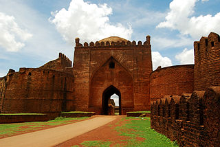
Basavakalyana fort, earlier known as Kalyana fort, is located in Bidar district in the Indian state of Karnataka. Its historic importance is dated to the 10th century. The capital of Chalukyas was also shifted from Manyakheta to Kalyana in the 10th century. The fort, integral to the Basavakalyana town, is also famous as Karmabhoomi of Basavanna and hundreds of other Sharanas.

The history of Telangana, located on the high Deccan Plateau, includes its being ruled by the Satavahana Dynasty, the Kakatiya Dynasty (1083–1323), the Musunuri Nayaks (1326–1356), the Delhi Sultanate, the Bahmani Sultanate (1347–1512), Golconda Sultanate (1512–1687) and Asaf Jahi dynasty (1724–1950).
Bidar is a historic place and city located in the north-eastern part of the South Indian state of Karnataka. Bidar is situated and built on the brink of a plateau, and thus stands above the lowlands (talghat) towards the north and the east.
Kaulas Fort is a historic fort in western Telangana in India. It was constructed by Rashtrakutas in the 9th century CE. It later came under the rule of Chalukyas of Badami, the Kakatiyas, Musunuri Nayaks, Bahmani Sultanate, Qutub Shahis, Mughals, Marathas and, finally, the Asaf Jahi rulers of the Hyderabad State. It is in the Kamareddy district, near the trijunction of Telangana, Karnataka and Maharashtra states. It has historically served as a strategic outpost contested by many kingdoms.