Bijapur Fort

Last updated

Bijapur Fort
Part of Bijapur
Bijapur, India
Part of Fort, Beejapore..jpg
View of Bijapur Fort from the moat
Bijapur citadel.jpg
Layout Plan of Bijapur Fort
India Karnataka location map.svg
Red pog.svg
Bijapur Fort
Coordinates 16°49′39″N75°42′31″E / 16.8276°N 75.7087°E / 16.8276; 75.7087
Type Fort
Site information
Controlled by Government of Karnataka
Open to
the public
Yes
ConditionRuins
Site history
Built16th century
Built by Yusuf Adil Shah in 1566
Materials Granites and lime mortar

The Bijapur Fort (Vijapur kote) is located in the Bijapur city in Bijapur District of the Indian state of Karnataka. Bijapur fort has a plethora of historical monuments of architectural importance built during the rule of Adil Shahi dynasty. [1] [2] [3]

Contents

The Adil Shahi Sultans who ruled for nearly 200 years in Bijapur had expended their utmost authority, almost exclusively, on architecture and the allied arts, each Sultan endeavored to excel his predecessor in the number, size, or splendor of his building projects. As a result, the buildings seen in and around Bijapur Fort and the town have been rightly called as the Agra of South India. [1] [2]

History

The rich history of the fort, the citadel, and other structures is subsumed in the history of Bijapur city, which was established in the 10th–11th centuries by the Kalyani Chalukyas. It was then known as Vijayapura (city of victory). The city came under the influence of the Khalji Sultanate in Delhi by the late 13th century. In 1347, the area was conquered by the Bahmani Sultanate of Gulbarga. By this time, the city was being referred as Vijapur or Bijapur. [1] [2]

Yusuf Adil Shah, son of Murad II, the Sultan of Turkey had joined the Bidar court of the sultanate in 1481 under the then Sultan Mohammed III. He had been purchased as slave by Mahmud Gavan, the prime minister of the kingdom. He was later, in 1481, appointed as the Governor of Bijapur for his loyalty and bravery shown in the active defense of the sultanate. The fort and the citadel or Arkilla and the Faroukh Mahal were built by him with the skilled architects and artisans whom he had inducted into his employment from Persia, Turkey and Rome. Yusuf declared himself independent of Sultan’s rule and thus established the Adil Shahi dynasty or the Bahmani kingdom, in 1489 (in 1482, the Bahmini empire broke into five kingdoms and Bijapur sultanate was one of them). [1] [2] [3] [4] [5]

Ibrahim Adil Shah, son of Yusuf Adil Shah by his Hindu wife Punji (daughter of a Maratha warrior), succeeded his father who died in 1510. Since he was a minor at the time of his father's death, there was an attempt to grab the throne, which was effectively thwarted by the timely intervention of his valiant mother fighting for her son's cause in male attire. He then became the ruler of Bijapur Sultanate. He was instrumental in making further additions to the fort and also building the Jami Masjid within the fort. [3] [4] [5]

Ibrahim Adil Shah’s successor Ali Adil Shah I forged an alliance with other Muslim rulers of the Deccan (other Shahi kingdoms of (Ahmednagar and Bidar). Ali built several structures in the fort and the city suburbs, such as the Gagan Mahal, Ali Rauza (his own tomb), Chand Bawdi (a large well) and the Jami Masjid.

Chand Bibi, the regent of Bijapur ChandBibiHawking.png
Chand Bibi, the regent of Bijapur

Since Ali did not have a son of his own, his nephew Ibrahim II was crowned the king. But he was also a minor when he was crowned and his mother Chand Bibi effectively protected him, acting as the regent of Bijapur. Ibrahim, the fifth king of the dynasty of Bahmanis, was a tolerant and an intellectual king who forged good relationship between Hindus and Muslims and also between Shia and Sunni Muslims in his kingdom and ushered harmony among the people of his kingdom; history has therefore titled him with the name of "Jagadguru Badshah". He ruled for 46 years. He also built Hindu temples within his palace precincts and composed verses dedicated to Saraswati (Hindu goddess of learning) and Ganapati, the Hindu god of wisdom. He was also a great patron of music and learning. He built the world-famous Gol Gumbaz (the second biggest dome in the world with whispering galleries). During his reign, the historic Mallik-E-Maidan, the gun position, was erected in the fort precincts. The gun is a massive arsenal of 4.45 metres (14.6 ft) length, which is seen even now at the same location in a good condition. [4] [5] [6]

In the last decade of Adil Shah’s power, when he fell sick, his wife Bariba is said to have ruled. After he died in 1646, his adopted son Ali Adil Shah II came to power but there were internal struggles for the reins of power. The dynasty's control thus weakened. Bijapur was greatly weakened after the defeat of Afzal Khan and his 10,000 man Bijapur forces by the Maratha ruler Shivaji Maharaj, who had attacked Bijapur repeatedly and plundered it but later agreed to an armistice to consolidate his forces to capture Karnataka. But after Shivaji Maharaj died, the Mughal led by Aurangzeb finally annexed the kingdom after the Siege of Bijapur in the year 1686 that eventually ended with the death of Sikandar Adil Shah the last of the Adil Shahi's. With this defeat, the 200-year rule of Adil Shahi dynasty ended and Bijapur sultanate was incorporated into the Mughal Empire, in 1686. During this period, Adil Shah had started building his mausoleum, called the Bara Kaman, but he died before he could complete it. [2] [7]

Two centuries later, in 1877, during the British rule, due to scarcity (famine conditions) Bijapur city was found in a desolate and deserted state that was compared to similarly placed ruined cities of Baalbek in Bekaa Valley of Lebanon or Pompeiopolis in Rome. The palaces and tombs in the fort were in ruins. Bijapur was like the city of the dead, for there was no water or food in the city. [8]

Structures

The fort precinct is studded with the historical fort, palaces, mosques, tombs and gardens built by the Adil Shahis with their deep interest in architecture (in Persian, Ottoman Turkish and the allied arts. Some ruins of ancient temples, predating the Adilshahi period, are also seen. The most striking structures, in the order of their importance, are the Citadel or Arkilla, the Jamia Masjid (or Jumma masjid), the Gagan Mahal palace, the tomb of Ali Rauza or Ibrahim Roza (tomb of Ibrahim Adil Shah I), Chand Bawdi or Taj Bavdi (a large well), Mahatar Mahal (Dilkusha Mahal), Malikah-e-Jahan Mosque, Jal Mahal, and also an innocuous well in the vicinity of the fort with a legend of a tragedy linked to a brave but jealous general of the dynasty. It is said that the Adilshahis, during their reign of 200 years, built over 50 mosques, 20 tombs and 20 palaces. Bijapur has, therefore, been called as Agra of South India. [1] [2] [3] [5] [9]

Apart from these monuments, Ibrahim II also built the Dattatreya Temple, to the west of the citadel. It contains a pair of paduka (foot sandals) of saint Narasimha Saraswati. [1]

Fort

The fort and the citadel within it were completed by Yusuf Adil Shah in 1566. [10] They were built in two concentric circles. The citadel at the centre of the two concentric circles has a circumferential length of 400 metres (1,300 ft). The east–west axis of the fort measures 3 kilometres (1.9 mi). The circumferential length of the fort’s outer wall, which encloses the old city, measures 10 kilometres (6.2 mi). It is strongly fortified with the most massive materials with ninety-six large bastions of various designs. [10] The bastions are decorated with "crenellations and interspersed with machicolations". In addition, there are ten other bastions at the five main gateways [10] (which are arched and decorated entrances) to the fort. It is surrounded by a moat of 30 feet (9.1 m) to 40 feet (12 m) width (assessed depth of 10 feet (3.0 m), but is presently silted up that even obscures its presence and hence its depth cannot be correctly stated). [10] The fort wall has varying height, about 50 feet (15 m) high. The width is about 25 feet (7.6 m); from bastion to bastion runs a battlemented curtained wall about 10 ft (3.0 m) high. [10] [9] [11] [12]

The five gateways in the fort are the Makka gate on the west, the Shahapur gate at the north-west corner, the Bahmani gate on the north, the Allahpur gate on the east, and the Fateh gate on the south-east.

In the days when Bijapur Sultanate commanded almost the whole of the Deccan territory, the strongly fortified fort had more than 1000 canons made of brass and iron. The palace inside was encompassed by two moats. As also reported, in the mid 16th century, the palace was guarded by 2000 men and the city had a garrison of 5000 men headed by Nammouth Chan, an Italian. [13]

Jamia masjid

Jamia Masjid
View from the south-east of the Jami Masjid, Bijapur..jpg Jumma Masjid - Quran.JPG
View of the Jami Masjid from the south-eastThe Quran, written in gold at Jumma Masjid’s mehrab

Jamia Masjid located in the southeast part of the city, the largest mosque of Bijapur, was started in 1565, but not fully completed. It has an arcaded prayer hall with fine aisles supported on massive piers and has an impressive dome in the façade which has nine bays. The large courtyard also has a water tank. It is called the Jami Masjid or Jumma Masjid as Qutba is read here every Friday. The masjid spreads over an area of 10,810 square metres (116,400 sq ft). The mosque building is in a rectangular shape of size 170 metres (560 ft) x 70 metres (230 ft). [14] The façade depicts nine large arches with five inner arches enclosing 45 compartments; the building is incomplete as two minarets are missing or not built. The dome is semicircular in shape. In 1636, the arched shaped mehrab in the mosque was gilded and inscribed with Persian verses, at the instance of Muhammad Adil Shah. Another interesting feature is the 2250 inlaid rectangular tiles in the form of prayer rugs seen in the prayer hall. The tiles were laid at the orders of the Mughal emperor Aurangzeb. Aurangzeb also got the mosque extended with an eastern gate and verandahs to the east, the south and the north. [3] [9] [15] [16]

Mehtar Mahal

Mehtar Mahal
MehatarMahal.jpg Close view of the doorway of the Mehtar Mahal, Bijapur.jpg
Mehtar MahalDoorway of the Mehtar Mahal

Though modestly sized, Mehtar Mahal dated to 1620 is one of the most elegant structures in the fort; the entry gate in particular has been built in Indo-Saracenic style. The façade has three arches, which depict exquisite "cornice supported on carved corbels". A gateway leads to the Mehtar mosque, which is a three-storey building. It has two slender minarets that are covered with delicately carved birds and rows of swans. The carvings are in Hindu architectural style, in the form of brackets supporting the balconies and stone trellis work. The building has a flat roof and minarets have rounded top. [9] [17] [18]

Barakaman
Barakaman- unfinished tomb of Ali Adil Shah BaraKaman.jpg
Barakaman- unfinished tomb of Ali Adil Shah

Barakaman (meaning 12 arches) is a mausoleum of Ali Roza built in 1672. It is located to the north of the citadel and the Gagan Mahal, in the midst of a public garden. It was initially called as Ali Roza, but Shah Nawab Khan changed its name to Bara Kaman, as this was the 12th monument built during his reign and was planned with 12 arches. [19] It is a 215 feet (66 m) square building built on a raised platform. It has now seven arches built of brown basaltic stone, in Gothic style. The tomb is in an inner raised enclosure, which contains the graves of Ali, queens and eleven other ladies, possibly belonging to the Zenana of the queens. [9] [18]

Malik-e-Maidan

The Malik-i-Maidan, the Gun position
View of the Malik-i-Maidan Gun in the Fort at Bijapur.jpg Malik E Maidan.jpg
View of the Malik-i-Maidan gun position in 1865
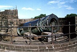
The Malik-i-Maidan is stated to be the largest piece of cast bronze ordnance in the world [10]

The Malik-i-Maidan (Master of the Battlefield), also called Burj-E-Sherz, was erected by Ibrahim Adil Shah II. It was named after the Battle of Talikota of 1565 in which the Vijayanagara Empire was routed. It is now located in the fort on its western ramparts between two bastions. It has a large cannon, 4.45 metres (14.6 ft) long and 1.5 metres (4.9 ft) in diameter with a 700 millimetres (28 in) bore. The cannon weighs 55 tonnes and is considered one of the largest medieval guns made. [20] The unusual feature of the gun is that its muzzle is shaped in the form of a lion head with carved open jaws as if devouring an elephant (depicted between the jaws). The gun is cool when touched even during the hot summer season and when tapped gives soft resonating sound. It is said that touching it brings good luck. From the inscriptions on the gun position, it is deduced that the gun was cast in 1549 at Ahmadnagar from bell metal by Muhammad Bin Husain Rumi. Another inscription records that Aurangzeb conquered Bijapur in 1685-86. [3] [5] [9] [18] [21] It is also said that the large weight of the canon discouraged the British from carrying it as a trophy to England. [8]

Gagan Mahal

Gagan Mahal or Heavenly Palace
View across the moat towards the Gagan Mahal and the Sat Manzili, Bijapur..jpg View of the Gagan Mahal or durbar hall, Bijapur.jpg
View of the Gagan Mahal and the Sat Manzili from the moatAnother view of Gagan Mahal

Gagan Mahal or Heavenly Palace was built by Ali Adil Shah I in 1561 as a royal palace with a durbar hall. It has three impressive arches and the central arch is the widest. The durbar hall was located in the ground floor while the first floor was built as the private residence of the royal family. But both floors are now in ruins. The façade of the palace has three arches; the central arch, which is the largest of the three, is 20 metres (66 ft) long and 17 metres (56 ft) high. [5] [9] [18] [22]

Sat Manzili

Sat Manzili was originally a seven-storeyed palace but now only five floors exist. It is conjectured that it was a pleasure pavilion built in 1583 during the reign of Ibrahim II Adil Shah. [23] An engraving of a painting of this building by W Turner can be seen in Wikisource-logo.svg The Palace of Seven Stories . with a poetical illustration by Letitia Elizabeth Landon and, as she writes 'No steps are heard in the ruined hall. Such is man's pride, and such is its fall.' In a note, she records a traditional reason for the construction of such an elevated structure. [24]

Asar Mahal

Asar Mahal or Dad Mahal or Asar-i-Sharaf
The Asar Mahal, Bijapur.jpg Asar-i-Sharaf. Fine verandah 33 ft x 120 ft, roof supported by four massive wooden pillars, fine reservoir in front 25 yds x 60 yds. -Bijapur-..jpg
View of Asar Mahal from the reservoirFine verandah, roof supported by four wooden pillars and reservoir

Asar Mahal or palace was constructed in 1646 by the Adil Shahis. It is located to the east of the citadel. A bridge connects it and it is well preserved. It is also known as Dad Mahal since it was initially used as hall of justice. It was later converted as reliquary and has become a highly revered place since it is said to hold two hairs from the beard of Prophet Mohammed. The portico has impressive wooden columns (four numbers of octagonal shape) and is double the normal height and has wooden panelled ceiling. It faces an artificial lake. The walls and ceiling of the hall display landscape paintings. Women are prohibited from entering this Mahal. [18] [25] [26] A picture of Assar Mahal, Beejapore by Thomas Boys was published in Fisher's Drawing Room Scrap Book, 1833 along with a poetical illustration by Letitia Elizabeth Landon (wrongly described as Ruins near Agra). [27]

Taj Bawdi

Taj Bawdi is a water reservoir that was built to commemorate Taj Sultana, Ibrahim II ’s first wife. The entrance arch is very impressive and has two octagonal towers; the east & west wings of the two towers were used as rest houses. [18]

Other attractions

Apart from the monuments within the fort, there are several monuments in Bijapur city of which the most famous is the Gol Gumbaz. The other structures of interest in close vicinity of the fort are the Sangeet – Nari Mahal and Saatkabar (which is linked to the story of a well and 60 graves).

Ibrahim Rauza

Ibrahim Rauza tomb Ibrahim Roza.jpg
Ibrahim Rauza tomb

Ibrahim Rauza (‘Rauza’ means "tomb") also known as Ali Rauza, built in 1627, contains the tomb of Ibrahim Adil Shah II and his queen Taj Sultana. It was originally intended to be the tomb for the queen. It is a fine square structure with twin buildings with delicate carvings. It was designed by the Persian architect, Malik Sandal (his grave also lies in the courtyard). The tomb (of Ibrahim Adil Shah II, his two sons, and his mother) on the left and a mosque on the right within it are set in a walled garden (about 140 metres (460 ft) square) facing each other over an ornamental pond. The tomb as such is in a central chamber of 13 metres (43 ft) square and has a ceiling that is divided into nine squares with curved sides. Graceful minarets mark the corners of each symmetrical building, surmounted by a dome rising from a lotus petal base. Steps are provided to approach the raised platform on which the two structures have been built. The structure has been erected on a single rock slab and has a basement, which was used to store ammunition and food. In the prayer hall in the mosque, there are two chains carved out of a single rock. It has impressive gateways. The doors are made of teak wood braced with metal strips and decorated. The inner perimeter of the Mausoleum has well-crafted arches. The outer walls of the tomb have panels displaying geometric and calligraphic designs in the form of perforated screens and shallow relief. The windows and doors also have similar motifs, which allow light to penetrate into the tomb chamber. A special acoustic feature of the mosque mentioned is that standing next to the grave of the Sultan inside the tomb at one end, prayers can be distinctly heard at the other end. Impressed by its architectural splendour, Henry Cousens, an expert in Art and Architecture called it the "Taj Mahal of the South". The left of the building resembles the Taj Mahal in Agra, The middle gateway resembles the Charminar in Hyderabad and the right of the building resembles the Bibi Ka Maqbara in Aurangabad. [1] [3] [5] [9] [28]

Sangeet – Nari Mahal

The Sangeet - Nari Mahal The Indian empire- history, topography, geology, climate, population, chief cities and provinces; tributary and protected states; military power and resources; religion, education, crime; land (14582909129).jpg
The Sangeet – Nari Mahal

The Sangeet – Nari Mahal built at Navraspur, Bijapur is located 3 kilometres (1.9 mi) away from Bijapur town. It is one of the important structures typically representing the Adilshahi architecture in the area. It was built in the 16th century. It now has ruins of a palace building and a reservoir, enclosed by a high wall. [29]

Saath Kabar

Saath Kabar (meaning: sixty graves) is called the 'dark tourist spot' in Bijapur as it is a moot witness to a very tragic story linked to it. Local stories and rumors allege that Afzal Khan, the cruel army chief of Ali Adil Shahi-II, killed his 63 wives out of cruel jealousy that they would remarry after his death. Before setting out for a crucial battle with Shivaji, the Maratha warrior, at Pratapgad in Maharashtra in 1659, Afzal Khan murdered his 63 wives at a well near Saath Kabar. [30] [ failed verification ] The trigger which caused this tragic decision was the prophecy that his astrologers had given that he would lose the war against Shivaji and would also surely die. He, therefore, took his wives to a well at the outer limits of the fort city and pushed them into the well one by one and killed them. When two of his wives tried to escape, they were chased by his soldiers and killed. All 63 wives, who were killed thus, were buried in a place near the well, which has come to be known as "Saath Kabar" (60 graves). The place is now a visitor attraction even though the historic rumor still has not be confirmed or verified. [30]

Visitor information

F.3' Citadel of Bejapoor. Plan..jpg It is well connected by road rail and air links.

Road – Bijapur city where the fort is located is 530 kilometres (330 mi) northwest of Bangalore, 650 kilometres (400 mi) from Mysore, and about 550 kilometres (340 mi) from Mumbai (Maharashtra). Road links with other towns in North Karnataka are; Aihole110 kilometres (68 mi), Saint Basaveshwara Pilgrim centre–67 kilometres (42 mi), Basavana Bagevadi43 kilometres (27 mi), Almatti - 56 kilometres (35 mi), Badami60 kilometres (37 mi), Gulbarga145 kilometres (90 mi), and Bidar256 kilometres (159 mi). [31]

Air – The nearest airport is at Belgaum (205 kilometres (127 mi)). [18]

Bijapur is a Broad gauge station of the South Western Railways with direct train connections to Bangalore, Mumbai, Hubli, Solapur and Shirdi. [31] [32]

Related Research Articles

<span class="mw-page-title-main">Deccan sultanates</span> Former states in India

The Deccan sultanates were five late-medieval Indian kingdoms—on the Deccan Plateau between the Krishna River and the Vindhya Range—that were ruled by Muslim dynasties: namely Ahmadnagar, Berar, Bidar, Bijapur, and Golconda. The sultanates had become independent during the break-up of the Bahmani Sultanate. The five sultanates owed their existence to the declaration of independence of Ahmadnagar in 1490, followed by Bijapur and Berar in the same year. Golconda became independent in 1518, and Bidar in 1528.

<span class="mw-page-title-main">Bijapur</span> City in Karnataka, India

Bijapur, officially known as Vijayapura, is the district headquarters of Bijapur district of the Karnataka state of India. It is also the headquarters for Bijapur Taluk. Bijapur city is well known for its historical monuments of architectural importance built during the rule of the Adil Shahi dynasty. It is also well known for the popular Karnataka premier league team, the Bijapur Bulls. Bijapur is located 519 km (322 mi) northwest of the state capital Bangalore and about 550 km (340 mi) from Mumbai and 210 km (130 mi) north east of the city of Belgaum.

<span class="mw-page-title-main">Gol Gumbaz</span> Mausoleum of Mohammed Adil Shah, Sultan of Bijapur

Gol Gumbaz, also written Gol Gumbad, is a 17th-century mausoleum located in Bijapur, a city in Karnataka, India. It houses the remains of Mohammad Adil Shah, seventh sultan of the Adil Shahi dynasty, and some of his relatives. Begun in the mid-17th century, the structure never reached completion. The mausoleum is notable for its scale and exceptionally large dome.

<span class="mw-page-title-main">Burhanpur</span> City in Madhya Pradesh, India

Burhanpur is a historical city in the Indian state of Madhya Pradesh. It is the administrative seat of Burhanpur District. It is situated on the north bank of the Tapti River and 512 kilometres (318 mi) northeast of city of Mumbai, 340 kilometres (211 mi) southwest of the state's capital city of Bhopal. The city is a Municipal Corporation.

<span class="mw-page-title-main">Bidar</span> City in North Karnataka, India

Bidar (/biːd̪ər/) is a city in the north-eastern part of Karnataka state in India. It is the headquarters of Bidar district, which borders Maharashtra and Telangana. It is a rapidly urbanising city in the wider Bidar Metropolitan area. The city is well known for its many sites of architectural, historical and religious importance. Bidar City have a population of more than 2 lakh and are likely to get upgraded to municipal corporation in the next 5 years.

<span class="mw-page-title-main">Adil Shahi dynasty</span> Muslim dynasty that ruled southwest India as the Sultanate of Bijapur from 1490 to 1686

The Adil Shahi or Adilshahi, was a Shia, and later Sunni Muslim, dynasty founded by Yusuf Adil Shah, that ruled the Sultanate of Bijapur, centred on present-day Bijapur district, Karnataka in India, in the Western area of the Deccan region of Southern India from 1489 to 1686. Bijapur had been a province of the Bahmani Sultanate (1347–1518), before its political decline in the last quarter of the 15th century and eventual break-up in 1518. The Bijapur Sultanate was absorbed into the Mughal Empire on 12 September 1686, after its conquest by the Emperor Aurangzeb.

<span class="mw-page-title-main">Mughal architecture</span> 16th–18th-century Indo-Islamic architecture

Mughal architecture is the type of Indo-Islamic architecture developed by the Mughals in the 16th, 17th and 18th centuries throughout the ever-changing extent of their empire in the Indian subcontinent. It developed from the architectural styles of earlier Muslim dynasties in India and from Iranian and Central Asian architectural traditions, particularly Timurid architecture. It also further incorporated and syncretized influences from wider Indian architecture, especially during the reign of Akbar. Mughal buildings have a uniform pattern of structure and character, including large bulbous domes, slender minarets at the corners, massive halls, large vaulted gateways, and delicate ornamentation; examples of the style can be found in modern-day Afghanistan, Bangladesh, India and Pakistan.

<span class="mw-page-title-main">Ibrahim Adil Shah II</span> Sultan

Ibrahim Adil Shah II was king of the Sultanate of Bijapur and a member of the Adil Shahi dynasty. Under his reign the dynasty had its greatest period as he extended its frontier as far south as Mysore. He was a skilful administrator, artist, poet and a generous patron of the arts. He reverted to the Sunni orthodoxy of Islam, but remained tolerant of other religions, including Christianity. However, during his reign high-ranking Shiite immigrants became unwelcome and in 1590, he ordered the confinement of criers who read the khutba in the Shia form. After his reign, increasing weakness permitted Mughal encroachment and the successful revolt of the Maratha king Shivaji, who killed the Bijapur general Afzal Khan and scattered his army. The dynasty left a tradition of cosmopolitan culture and artistic patronage whose architectural remains are to be seen in the capital city of Bijapur.

<span class="mw-page-title-main">Indo-Islamic architecture</span> Islamic architecture in Indian subcontinent

Indo-Islamic architecture is the architecture of the Indian subcontinent produced by and for Islamic patrons and purposes. Despite an initial Arab presence in Sindh, the development of Indo-Islamic architecture began in earnest with the establishment of Delhi as the capital of the Ghurid dynasty in 1193. Succeeding the Ghurids was the Delhi Sultanate, a series of Central Asian dynasties that consolidated much of North India, and later the Mughal Empire by the 15th century. Both of these dynasties introduced Islamic architecture and art styles from West Asia into the Indian subcontinent.

<span class="mw-page-title-main">Chand Bibi</span> Regent of Bijapur and Ahmednagar

Sultana Chand Bibi was an Indian ruler and warrior. She acted as the Regent of Bijapur Sultanate during the minority of Ibrahim Adil Shah II in 1580-1590, and regent of Ahmednagar Sultanate during the minority of her great nephew Bahadur Shah in 1595-1600. Chand Bibi is best known for defending Ahmednagar against the Mughal forces of Emperor Akbar in 1595.

<span class="mw-page-title-main">Jama Mosque, Bijapur</span> Mosque in India

The Jama Masjid of Bijapur is a congregational mosque in the Indian state of Karnataka. Initiated by Ali Adil Shah I of the Bijapur Sultanate in the 16th century, the mosque was never completed. It is the largest mosque in Bijapur, and has a capacity of 4000 worshippers.

<span class="mw-page-title-main">Bidar Fort</span> Fort in the Bidar, Karnataka, India

Bidar Fort is located in old city area, Bidar, Karnataka, India. The fort, the city and the district are all affixed with the name Bidar. Sultan Ahmad Shah I of the Bahmanid dynasty shifted his capital from Gulbarga to Bidar in 1427 and built his fort along with a number of Islamic monuments. There are over 30 monuments inside Bidar fort.

<span class="mw-page-title-main">Gulbarga Fort</span>

The Gulbarga Fort is located in Kalaburagi in the Kalaburagi district of North Karnataka. This fort was originally constructed by a hindu king Raja Gulchand, it was subsequently significantly enlarged in 1347 by Al-ud-din Hasan Bahmani of the Bahmani Dynasty after he cut off his ties with the Delhi Sultanate; Islamic monuments such as mosques, palaces, tombs, and other structures were also built later within the refurbished fort. The Jami Masjid built later, within the fort, in 1367, is a unique structure built in Persian architectural style, fully enclosed, with elegant domes and arched columns, which is unlike any other mosque in India. It was built to commemorate the establishment of the dynastic rule of the Bahmani kingdom at Kalaburagi fort between 1327 and 1424. It remained the capital of the Bahmani Kingdom till 1424 where after the capital was shifted to Bidar Fort, as Bidar had better climatic conditions.

<i>Persian Inscriptions on Indian Monuments</i> Book by Hekmat E Shirazi

Persian Inscriptions on Indian Monuments is a book written in Persian by Dr Ali Asghar Hekmat E Shirazi and published in 1956 and 1958 and 2013. New edition contains the Persian texts of more than 200 epigraphical inscriptions found on historical monuments in India, many of which are currently listed as national heritage sites or registered as UNESCO world heritage, published in Persian; an English edition is also being printed.

<span class="mw-page-title-main">Architecture of the Deccan sultanates</span>

Deccani Architecture refers to the architectural styles developed during the Deccan sultanate period. The Deccan sultanates were five dynasties that ruled late medieval kingdoms, namely, Bijapur, Golkonda, Ahmadnagar, Bidar, and Berar in south-western India. The Deccan sultanates were located on the Deccan Plateau. Their architecture was a regional variant of Indo-Islamic architecture, heavily influenced by the styles of the Delhi Sultanate and later Mughal architecture, but sometimes also directly from Persia and Central Asia.

<span class="mw-page-title-main">Ali Barid Shah I</span> Shah of Bidar

Ali Barid Shah I was the third ruler of the Barid Shahi dynasty at Bidar. He succeeded his father in 1540, and ruled until his death in 1580. He was considered a man of letters, and invited scholars and craftsmen from all over the Indian subcontinent to his capital. He is also known to have played a key logistical role in the Battle of Talikota.

<span class="mw-page-title-main">Malik Rihan Dargah, Sira</span>

Malik Rihan Dargah, also known as Malik Rihan tomb, is a mausoleum in Sira, Karnataka, India. It contains the grave of Malik Rihan who was the governor of Sira province in the 17th-century. It has a square plan and illustrates the Indo-Saracenic style in Deccan architecture.

<span class="mw-page-title-main">Qutb Shahi architecture</span> Indo-Islamic architectural style

Qutb Shahi architecture is the distinct style of Indo-Islamic architecture developed during the reign of the Qutb Shahi dynasty, also known as the Golconda Sultanate.

<span class="mw-page-title-main">Ibrahim Rauza</span> Building in Bijapur, India

Ibrahim Rauza is a complex consisting of a mausoleum and a mosque, located in Bijapur, in the Indian state of Karnataka. It was built in the 17th century by Ibrahim Adil Shah II.

References

  1. 1 2 3 4 5 6 7 "Heritage Areas". Bijapur. Office Of the Commissioner, Archaeology, Museums & Heritage, Mysore: Government of Karnataka. Archived from the original on 20 August 2009. Retrieved 28 November 2009.
  2. 1 2 3 4 5 6 "Welcome to Bijapur". Archived from the original on 21 February 2009. Retrieved 29 November 2009.
  3. 1 2 3 4 5 6 7 "A brief History". Bijapur Cith Municipal Council. Archived from the original on 30 October 2005. Retrieved 28 November 2011.
  4. 1 2 3 Dr. (Mrs) Jyotsna Kamat. "History of Bijapur: The Adil Shahi Kingdom (1510 CE to 1686 CE)" . Retrieved 29 November 2009.
  5. 1 2 3 4 5 6 7 "Bijapur Heritage". The Tribune. 24 March 2002. Retrieved 28 November 2009.
  6. Jyotsna Kamat. "History of Bijapur: Ibrahim Adil Shah II". Kamat potpourri. Retrieved 28 November 2009.
  7. Lach, Donald.F (1993). Asia in the making of Europe, Volume 3, Book 2. p. 860 (notes). ISBN   0-226-46754-6 . Retrieved 29 November 2009.{{cite book}}: |work= ignored (help)
  8. 1 2 The Fortnightly, Volume 3. 1880. pp. 225–226. Retrieved 29 November 2009.{{cite book}}: |work= ignored (help)
  9. 1 2 3 4 5 6 7 8 "Places to visit". Archived from the original on 21 December 2008. Retrieved 28 November 2009.
  10. 1 2 3 4 5 6 Chisholm, Hugh, ed. (1911). "Bijapur"  . Encyclopædia Britannica . Vol. 3 (11th ed.). Cambridge University Press. p. 928.
  11. "Part of Fort, Beejapore". British Library On Line Gallery. Retrieved 28 November 2009.
  12. "Citadel of Bejapoor Plan". British Library On Line Gallery. Retrieved 29 November 2009.
  13. Lach p. 859
  14. "Tourism details nearby Bijapur city". Juma Masjid. Bijapur City Municipal Council. Archived from the original on 12 February 2006. Retrieved 30 November 2009. This imposing mosque (the rectangle is 170m x 70 m) is incomplete, lacking in 2 minarets
  15. "Close view of the central portion of the screen of the east façade of the Jami Masjid, Bijapur". British Library On Line Gallery. Retrieved 29 November 2009.
  16. "View from the south-east of the Jami Masjid, Bijapur". British Library On Line Gallery. Retrieved 29 November 2009.
  17. "General view of the Mehtar Mahal Mosque". British Library On Line Gallery. Retrieved 28 November 2009.
  18. 1 2 3 4 5 6 7 "Bijapur: Karnataka" . Retrieved 29 November 2009.
  19. "Barakaman (Ali Roza)". A mausoleum of Ali Roza built in 1672. It was previously named as Ali Roza, but Shah Nawab Khan changed its name to Bara Kaman as this was the 12th monument during his reign. It has now seven arches and the tomb containing the graves of Ali, his queens and eleven other ladies possibly belonging to the Zenana of the queens.
  20. "Bijapur, Karnataka". Burj-E-Sherz. Retrieved 30 November 2009. Malik-e-Maidan cannon (Lord of the Battlefield). It was used in the battle of Talikot, when the Vijayanagara Empire fell. Measuring 4.45 m in length, 1.5 m in diameter and weighing an estimated 55 tonnes, it is one of the largest medieval guns ever made
  21. "View of the Malik-i-Maidan Gun in the Fort at Bijapur". British On Line gallery. Retrieved 28 November 2009.
  22. "View across the moat towards the Gagan Mahal and the Sat Manzili, Bijapur". British Library On Line Gallery. Retrieved 29 November 2009.
  23. "View of the Gagan Mahal or durbar hall, Bijapur". British Library On Line Gallery. Retrieved 29 November 2009.
  24. Landon, Letitia Elizabeth (1831). "poetical illustration". Fisher's Drawing Room Scrap Book, 1832. Fisher, Son & Co.Landon, Letitia Elizabeth (1831). "picture". Fisher's Drawing Room Scrap Book, 1832. Fisher, Son & Co.
  25. "The Asar Mahal, Bijapur". British Library On-Line Gallery. Retrieved 28 November 2009.
  26. "Asar-i-Sharaf. Fine verandah 33 ft x 120 ft, roof supported by four massive wooden pillars, fine reservoir in front 25 yds x 60 yds. Bijapur". British Library On-Line Gallery. Retrieved 28 November 2009.
  27. Landon, Letitia Elizabeth (1832). "poetical illustration". Fisher's Drawing Room Scrap Book, 1833. Fisher, Son & Co.Landon, Letitia Elizabeth (1832). "picture". Fisher's Drawing Room Scrap Book, 1833. Fisher, Son & Co.
  28. "Ibrahim Rozah Tomb". British Library On-Line Gallery. Retrieved 28 November 2009.
  29. "Sangeet – Nari Mahal, Navraspur, Bijapur" (PDF). National Informatics Centre, Archaeological Survey of India. p. 55. Retrieved 29 November 2009.
  30. 1 2 "Jealousy is a Green-Eyed Monster" . Retrieved 27 November 2009.
  31. 1 2 "How to reach Bijapur". Archived from the original on 21 December 2008. Retrieved 28 November 2009.
  32. "South Western Railway". Archived from the original on 25 February 2011. Retrieved 28 November 2009.