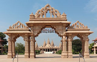
Bhavnagar is a city in the Bhavnagar district of the Saurashtra region of Gujarat, a state of India. It was founded in 1724 by Bhavsinhji Takhtasinhji Gohil (1703–1764). It was the capital of Bhavnagar State, which was a princely state before it was merged into the Indian Union in 1948. It is now the administrative headquarters of the Bhavnagar district.
The Muzaffarid dynasty, sometimes referred as Ahmedabad dynasty, were Sultans of Gujarat in western India from 1391 to 1583. The founder of the dynasty was Zafar Khan who was governor of Gujarat under the Delhi Sultanate. Zafar Khan's father Sadharan, has been variously described as a Tank Rajput or a Khatri convert from Hinduism to Islam. He adopted the name Wajih-ul-Mulk. He was originally from Southern Punjab, rising to nobel status in the Delhi Sultan's court. His Hindu forebearers claimed descend from Rāmachandra, who the Hindus worshipped as God. When the Sultanate was weakened by the sacking of Delhi by Timur in 1398, and Zafar Khan took the opportunity to establish himself as sultan of an independent Gujarat. His son, Ahmed Shah I established the capital at Ahmedabad. The dynasty ruled for almost 200 years, until the conquest of Gujarat by the Mughal Empire in 1572. The sultanate reached its peak of expansion under Mahmud Begada, reaching east into Malwa and west to the Gulf of Kutch.
Sultan Mahmud Begada or Mahmud Shah I, was the most prominent Sultan of Gujarat Sultanate. Raised to the throne at young age, he successfully captured Pavagadh and Junagadh forts in battles which gave him his name Begada. He established Champaner as the capital.
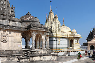
Bhavnagar District is a district of southeastern Gujarat, India, on the Saurashtra peninsula. It is also known as Gohilwar as a major portion of Bhavnagar district was ruled by Gohil Rajputs. The administrative headquarters is in the town of Bhavnagar.

Radhanpur is a town and a municipality in Patan district in the Indian state of Gujarat.
The history of Gujarat began with Stone Age settlements followed by Chalcolithic and Bronze Age settlements like Indus Valley Civilisation. Gujarat's coastal cities, chiefly Bharuch, served as ports and trading centers in the Nanda, Maurya, Satavahana and Gupta empires as well as Western Kshatrapas period. After the fall of the Gupta empire in the 6th century, Gujarat flourished as an independent Hindu/Buddhist state. The Maitraka dynasty, descended from a Gupta general, ruled from the 6th to the 8th centuries from their capital at Vallabhi, although they were ruled briefly by Harsha during the 7th century. The Arab rulers of Sindh sacked Vallabhi in 770, bringing the Maitraka dynasty to an end. The Gurjara-Pratihara Empire ruled Gujarat after from the 8th to 10th centuries. As well as, for some periods the region came under the control of Rashtrakuta Empire and Pala Empire. In 775 the first Parsi (Zoroastrian) refugees arrived in Gujarat from Greater Iran.
Ahmedabad is the largest city in the state of Gujarat. It is located in western India on the banks of the River Sabarmati. The city served as political as well as economical capital of the region since its establishment. The earliest settlement can be recorded around the 12th century under Chaulukya dynasty rule. The present city was founded on 26 February 1411 and announced as the capital on 4 March 1411 by Ahmed Shah I of Gujarat Sultanate as a new capital. Under the rule of sultanate (1411–1511) the city prospered followed by decline (1511–1572) when the capital was transferred to Champaner. For next 135 years (1572–1707), the city renewed greatness under the early rulers of Mughal Empire. The city suffered due to political instability (1707–1817) under late Mughal rulers followed by joint rule between Maratha and Mughal. The city further suffered following joint Maratha rule. The city again progressed when politically stabilized when British East India Company established the rule in the city (1818–1857). The city further renewed growth when it gain political freedom by establishment of municipality and opening of railway under British crown rule (1857–1947). Following arrival of Mahatma Gandhi in 1915, the city became centre stage of Indian independence movement. Many activists like Sardar Patel served the municipality of the city before taking part in the movement. After independence, the city was a part of Bombay state. When Gujarat was carved out in 1960, it again became the capital of the state until establishment of Gandhinagar in 1965. Ahmedabad is also the cultural and economical centre of Gujarat and the seventh largest city of India.

Botad is a city and district headquarters of Botad district, Gujarat, India. It is about 92 km from Bhavnagar and 133 km From Ahmedabad by road distance.

Ghogha is a census town in Bhavnagar district in the state of Gujarat, India. It is situated on the mid-western bank of the Gulf of Khambhat. It was an important historical commercial port on the Arabian Sea until the development of nearby Bhavnagar in the nineteenth century.

The Gujarat Sultanate, was a Medieval Indian kingdom established in the early 15th century in Western India, primarily in the present-day state of Gujarat, India. The dynasty was founded by Sultan Zafar Khan Muzaffar, identified variously as a Tanka Rajput or a Khatri from southern Punjab. He rose to the nobility after marriage of his sister with Firuz Shah Tughlaq, the Delhi Sultan. He was Governor of Gujarat and became independent from Delhi after Tīmūr devastated the city. Zafar Khan defeated Farhat-ul-Mulk near Anhilwada Patan and made the city his capital. Following Timur's invasion of Delhi, the Delhi Sultanate weakened considerably and so he declared himself independent in 1407 and formally established Gujarat Sultanate. The next sultan, his grandson Ahmad Shah I founded the new capital Ahmedabad in 1411. His successor Muhammad Shah II subdued most of the Rajput chieftains. The prosperity of the sultanate reached its zenith during the rule of Mahmud Begada. He subdued most of the Rajput chieftains and built navy off the coast of Diu. In 1509, the Portuguese wrested Diu from Gujarat sultanate following the battle of Diu. The decline of the Sultanate started with the assassination of Sikandar Shah in 1526. Moghul emperor Humayun attacked Gujarat in 1535 and briefly occupied it, during which Bombay and Bassein became a Portuguese colony, thereafter Bahadur Shah was killed by the Portuguese while making a deal in 1537. The end of the sultanate came in 1573, when Akbar annexed Gujarat in his empire. The last ruler Muzaffar Shah III was taken prisoner to Agra. In 1583, he escaped from the prison and with the help of the nobles succeeded to regain the throne for a short period before being defeated by Akbar's general Abdul Rahim Khan-I-Khana.

Idar State, also known as Edar, was a princely state that was located in present-day Gujarat state of India. During the British Raj era, it was a part of the Mahi Kantha Agency, within the Gujarat Division of Bombay Presidency.
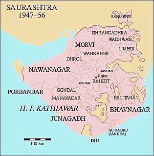
Bhavnagar State was a princely state during the British Raj. It was part of Kathiawar Agency in Saurashtra. the Kotwals of the royal palace of Bhavnagar were Talpada Kolis of Radhavanaj village of Kheda district.
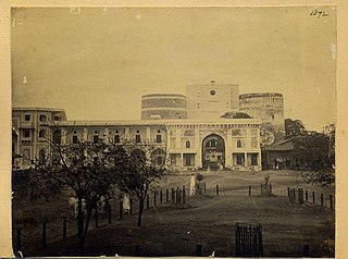
Bhadra Fort is situated in the walled city area of Ahmedabad, India. It was built by Ahmad Shah I in 1411. With its well carved royal palaces, mosques, gates and open spaces, it was renovated in 2014 by Ahmedabad Municipal Corporation (AMC) and Archaeological Survey of India (ASI) as a cultural centre for the city.

Damaji Rao Gaekwad was the second Maharaja of Baroda reigning from 1732 to 1768 until his death.

Gaekwad Haveli is a historical haveli building in Ahmedabad. It was built in 1738. It was used as a seat of Gaekwad during Maratha rule in Ahmedabad. It was later converted into barracks and arsenal under British rule. Later it was used as railway depot and police crime branch headquarters. It was restored in 2014.
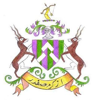
Radhanpur is a town and a municipality in Patan district in the Indian state of Gujarat. Radhanpur belonged to the Vaghelas in early years and later it was held as a fief under the Gujarat Sultanate by Fateh Khan Baloch. During Mughal period, the descendants of Babi dynasty were appointed as the governor of Radhanpur and other villages of North Gujarat. After decline of Mughal, they became free and established themselves as independent rulers. In 1743, Babi descendant Jawan Mard Khan II took over viceroyalty of Ahmedabad and controlled several villages in North Gujarat. He was defeated by Maratha Gaekwads in 1753 at Ahmedabad and Gaekwads agreed to his demand of control of villages in North Gujarat headquartered at Radhanpur State. His descendants lost some of these villages to Gaekwads subsequently. In 1813, Sher Khan made a treaty with the Gaekwar and British and became British protectorate. His descendants ruled the state until independence of India in 1947.
The Mughal Empire's province Gujarat was managed by the Viceroys appointed by the emperors. On the death of the emperor Jahangir, his son Shah Jahan ascended to the throne in 1627. His Gujarat viceroy Sher Khán Túar worked for relief in 1631-31 femine in the province. Shah Jahan sent his men to expand its territories further south. Between 1632 and 1635, four viceroys were appointed due to their precious gift to the emperor and they could not manage the province well. Kolis of Kankrej in north Gujarat committed excesses and the Jam of Nawanagar did not paid the tribute. Soon Azam Khan was appointed who put the province in order by subduing Kolis in north and Kathis in Kathiawad. He also made the Jam of Nawanagar surrender. The next viceroy Ísa Tarkhán carried out financial reforms. In 1644, the Mughal prince Aurangzeb was appointed as the viceroy who was engaged in religious disputes for destroying a Jain temple in Ahmedabad. Due to his disputes, he was replaced by Sháistah Khán who failed to subdue Kolis. So the prince Murad Bakhsh was appointed as the viceroy in 1654. He restored the disorder soon. In 1657, hearing news of Shah Jahan's severe illness, Murad Bakhsh declared himself the emperor and rebelled with his brother Aurangzeb. They defeated the Jaswant Singh and Kásam Khán, whom Sháh Jahán had appointed viceroys of Málwa and Gujarát respectively in the battle of Dharmatpur. They further went to the capital, Agra but were confronted by Dara Shikoh. They defeated him in the Battle of Samugarh (1658). Soon Aurangzed dumped and imprisoned Murad Bakhsh, confined his father and declared himself the emperor in 1658.
The Mughal Empire's province Gujarat was under attack of the Marathas since last half century. The chief Maratha houses, Gaikwar and Peshwa had made peace with each other and driven out the Mughal nobles under the emperor Alamgir II. One such noble, Momin Khan, had countered their advances and recovered Ahmedabad in 1756 lost to the Marathas few years ago. After a long siege, Ahmedabad fell again in hands of the Marathas. The Marathas levied tributes across Gujarat. In 1759, the English of the British East India Company captured Surat. Sadashiv Ramchandra was appointed as a viceroy by Peshwa in 1760 followed by Apa Ganesh in 1761. Following defeat of Marathas in the Third Battle of Panipat (1761), the nobles briefly recovered towns from the Marathas but soon had to surrender. Thus the Marathas firmly established themselves in Gujarat.
Mandalika III, called by epithet Ra Gangajalio, was a Chudasama king of Saurashtra region of western India who reigned from 1451 CE to 1472 CE. His capital was at Junagadh.
The Gohil dynasty or Guhilas of Saurashtra ruled parts of Saurashtra region of present-day Gujarat state of India as subordinates or independents starting 12th century. Their origin is traced to Guhila dynasty of Mewar and they had migrated to Saurashtra in 12th century. The earliest known inscription of Gohils is found from Mangrol so they must be ruling in southwest of peninsula under Chaulukya dynasty. They later moved to the east coast where they established themselves and the region came to be known as Gohelwar and ruled till the independence of India in 1947. The erstwhile princely states of Bhavnagar, Palitana, Lathi, Vala and Rajpipla belonged to Gohil rulers.


