
The Nelson River is a river of north-central North America, in the Canadian province of Manitoba. The river drains Lake Winnipeg and runs 644 kilometres (400 mi) before it ends in Hudson Bay. Its full length is 2,575 kilometres (1,600 mi), it has mean discharge of 2,370 cubic metres per second (84,000 cu ft/s), and has a drainage basin of 1,072,300 square kilometres (414,000 sq mi), of which 180,000 square kilometres (69,000 sq mi) is in the United States.
The Nisichawayasihk Cree Nation is a Cree-speaking community of about 4,200 Cree centered in Nelson House, Manitoba, Canada. Nelson House is located about 80 kilometres (50 mi) west of Thompson and is accessible via the mixed paved and gravel Provincial Road 391. Nisichawayasihk means where three rivers meet in Cree and describes Nelson House which is located at the convergence of the Burntwood River, Footprint and Rat Rivers.
Selkirk is a provincial electoral division in the Canadian province of Manitoba. It was created by redistribution in 1957 from part of St. Andrews, and has formally existed since the provincial election of 1958. It is named after the city of Selkirk, which in turn was named for Thomas Douglas, 5th Earl of Selkirk, who set up the Red River Colony colonization project in 1811.
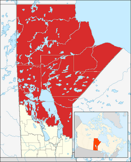
Northern Manitoba is the most northerly region of the Canadian province of Manitoba, added to the province during the last major expansion of its boundaries in 1912. Forestry, mining and hydro-electric development are significant economic drivers with long-term consequences to the environment in the region.
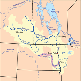
The Sheyenne River is one of the major tributaries of the Red River of the North, meandering 591 miles (951 km) across eastern North Dakota, United States.
The Rural Municipality of Alexander is a rural municipality in the Eastern region of Manitoba, Canada. The office is located in St. Georges, Manitoba. The town of Powerview-Pine Falls lies adjacent to the municipality, as does the Sagkeeng First Nation Indian reserve. The Chevrefils District and Broadlands are located in the R.M.
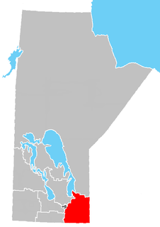
The Eastman Region--also known as Division No. 1-- is located in the south-eastern corner of the Canadian province of Manitoba. It is bounded on the north by the Winnipeg River and Lake Winnipeg, on the east by the Manitoba-Ontario border, on the south by the Canada–US border and on the west by the Red River. It is bordered on the north by the Northern Region, on the east by Northwestern Ontario on the south by the state of Minnesota, on the west by the Pembina Valley Region and the Interlake Region.
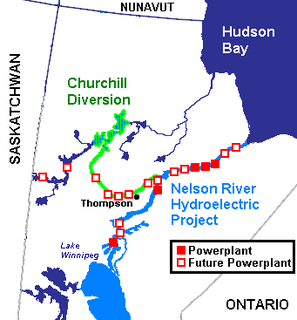
The Nelson River Hydroelectric Project refers to the construction of a series of dams and hydroelectric power plants on the Nelson River in Northern Manitoba, Canada. The project began to take shape in the late 1950s, with the planning and construction of the Kelsey dam and hydroelectric power station, and later was expanded to include the diversion of the upper Churchill River into the Nelson River and the transformation of Lake Winnipeg, the world's 11th largest freshwater lake, into a hydroelectric reservoir. The project is owned and operated by Manitoba Hydro, the electrical utility in the province.
St. Malo is an unincorporated community recognized as a local urban district located in the Rural Municipality of De Salaberry, approximately 70 km south of The Forks, Winnipeg, Manitoba. Most of the community's residents are bilingual francophone of Métis or Québécois heritage.
Split Lake is a community in Manitoba on the north shore of Split Lake (Manitoba) on the Nelson River about 150 miles west southwest of the river's mouth at Hudson Bay and is within Split Lake 171, a reserve of the Tataskweyak Cree Nation.
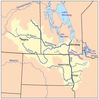
The Roseau River is a 214-mile-long (344 km) tributary of the Red River of the North, in southern Manitoba in Canada and northwestern Minnesota in the United States. Via the Red River, Lake Winnipeg and the Nelson River, it is part of the watershed of Hudson Bay.

Lake St. Joseph is a large lake in Kenora District and Thunder Bay District in Northwestern Ontario, Canada. It is in the James Bay drainage basin and is the source of the Albany River. The east end of the lake can be reached using Ontario Highway 599 from the town of Ignace, 260 kilometres (160 mi) to the south on Ontario Highway 17. The nearest town is Pickle Lake, 30 kilometres (19 mi) north along Highway 599.

The Seine River is a tributary of the Red River of the North that runs through southeastern Manitoba, Canada. It is one of the four rivers of the city of Winnipeg.

Red Deer Lake is a lake in western Manitoba, Canada. It is located approximately 5 miles (8.0 km) north of Barrows and 10 miles (16 km) west of Dawson Bay which is the northwest part of Lake Winnipegosis, and 8 miles (13 km) east of the Saskatchewan border.
The Manitoba Watershed District Program is a provincial-municipal partnership directed to the conservation and management of water and soil resources. There are 14 watershed districts including more than 130 municipalities covering almost all of the agricultural areas of Manitoba, Canada. The Province provides substantial funding and general guidance but the programs are developed and administered locally. The districts spend more than $8 million each year on a wide variety of conservation programs.
The Burntwood River is a river in northeast Manitoba, Canada between the Churchill River and the Nelson River. Outsiders may know it as the river that passes through Thompson, Manitoba. It is over 320 kilometres (200 mi) long and flows mostly east to join the Nelson River at Split Lake, Manitoba.
The Rat River is a tributary of the Burntwood River in Manitoba, Canada.
Rat River Settlement is an informal area within the Rural Municipality of De Salaberry in the province of Manitoba, Canada located east and south of the community of Otterburne, north and south of the village of St-Pierre-Jolys and northeast and southeast of the CP Emerson subdivision's former Carey rail siding.
