Soweto is a township of the City of Johannesburg Metropolitan Municipality in Gauteng, South Africa, bordering the city's mining belt in the south. Its name is an English syllabic abbreviation for South Western Townships. Formerly a separate municipality, it is now incorporated in the City of Johannesburg Metropolitan Municipality, Suburbs of Johannesburg.
Otsego County is a county located in the U.S. state of Michigan. As of the 2010 United States Census, the population was 24,164. The county seat is Gaylord. The county was founded in 1840 and organized in 1875.

Laudium is an Indian township southwest of central Pretoria, in the City of Tshwane Metropolitan Municipality. Claudius is a neighboring, largely residential suburb that is effectively an extension of Laudium.

Diepsloot, Afrikaans for "deep ditch", is a densely populated township in the north of Johannesburg. It is located in the newly formed Region A of the City of Johannesburg Metropolitan Municipality. Law and order is extremely bad here. It is made up of fully government-subsidised housing, brick houses built by landowners, partially government subsidised houses as well as shacks. A large proportion (45.5%) of residents rent their property from a landowner who has subdivided their land.
Lenasia is a formerly racially segregated Indian township south of Soweto in Gauteng Province, South Africa. It is part of the City of Johannesburg Metropolitan Municipality. Lenasia is approximately 35 kilometres southwest of the Johannesburg central business district and 45 kilometres south of the Sandton central business district.
Carletonville is a town in the West Rand District Municipality in Gauteng, South Africa, just north of the richest gold-mining area in the world. At 3,749 m, Western Deep Levels holds the record for the world's deepest gold mine.

Bela-Bela is a town in the Limpopo Province of South Africa. Deriving its name from the geothermic hot springs around which the town was built, it was called Warmbaths, until 2002.
Rivonia is a suburb of Johannesburg, South Africa in the Sandton area. It is located in Region E of the City of Johannesburg Metropolitan Municipality. Rivonia is one of the most affluent residential and business suburbs of Johannesburg, and regarded as the hub of upstart and established I.T. companies. The main retail thoroughfare in the area, Rivonia Boulevard, is the location of several shopping complexes as well as many other shops and restaurants. The area known as Rivonia includes the original township of Edenburg, Edenburg Extension 1, and 19 smaller extensions designated 'Rivonia Extension ...', numbered from 0 to 25. There is no designated township called Rivonia. The post code for Rivonia is 2128.
Bophelong meaning 'a place of life' is a township near Vanderbijlpark, Gauteng, South Africa. It was established in 1955 to house black residents who worked in Vanderbijlpark and Vereeniging.
Tsakane (a.k.a.) Mashona is a township located in Ekurhuleni, Gauteng, South Africa. It was established during the early 1960s due to Apartheid's segregationist policies and was formally founded as a designated area. Tsakane is a Tsonga word which means joy or happiness.

Langa is a township and suburb of Cape Town, South Africa. It was established in 1927 in terms of the 1923 Urban Areas Act. Similar to Nyanga, Langa is one of the many areas in South Africa that were designated for Black Africans before the apartheid era. It is the oldest of such suburbs in Cape Town and was the location of much resistance to apartheid. Langa is also where several people were killed on 21 March 1960 same day as the Sharpeville massacre, during the anti-pass campaign. On 21 March 2010, now 50 years later, a monument was unveiled by the government in remembrance of the people who lost their lives.

Ndabeni is an industrial suburb of Cape Town, South Africa, mainly occupied by light industries such as textiles and clothing. It is located about 6 km east of Cape Town city centre and is serviced by a railway station. Ndabeni is bordered to the south east by Pinelands and to the north by Maitland. Its postcode is 7405.
Tsotsitaal is a vernacular derived from a variety of mixed languages mainly spoken in the townships of Gauteng province, but also in other agglomerations all over South Africa. Tsotsi is a Sesotho slang word for a "thug" or "robber". The word taal in Afrikaans means "language".
Ga-Rankuwa is a township located about 37 km north of Pretoria. Provincially it falls Gauteng province, but it used to be under North West Province, as it belonged to Bophuthatswana, ruled by Lucas Mangope, during the apartheid years.

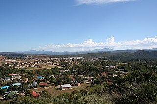
Whittlesea is a semi-rural town situated in the Hewu district, 37 km south of Queenstown, Eastern Cape Province, South Africa. The town is made up townships of Ekuphumleni, Bhede, Extension 4, Extension 5 and Sada. The town falls under the Enoch Mgijima Local Municipality which is under the Chris Hani District Municipality. Surrounding Whittlesea are 36 villages which make up the Hewu district.

Prieska is a town on the south bank of the Orange River, in the province of the Northern Cape, in western South Africa.
Ibhayi is a large township near Port Elizabeth, South Africa.
Thabong is a large township on the goldfields of the Free State province in South Africa. The township was established during the years of segregation of black people as well as the township of Bronville for coloured people adjacent to the city of Welkom, to accommodate workers at the world's richest gold mines.
Noordgesig is a township in Soweto, situated at the edge of area's northern most boundary, but within its territory. It is the first township seen on entering Soweto from the frequently used New Canada Road. Noordgesig is a Coloured township. It is colloquially called "Bulte"(meaning Hills) by its residence and neighbors, as depicted by the Mine Dumps surrounding the Township. The name "Bulte" was coined as a form of endearment by the residence for the longest time.