
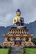
 Large Gautama Buddha statue in Buddha Park of Ravangla, Sikkim
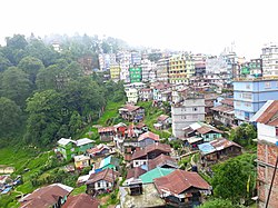 View of Ravangla town
 Ravangla main street
 Tibetan Carpet Factory of Ravangla, Sikkim
 View of the hotels and the Jeep stand
Ravangla Rabong | |
|---|---|
 Ravangla, Namchi District, 737139 | |
 Ravangla Location in Sikkim, India  Ravangla Ravangla (India) | |
| Coordinates: 27°17′33″N88°21′34″E / 27.29250°N 88.35944°E | |
| Country | |
| State | |
| District | Namchi |
| Population (2020) [1] | |
• Total | 47,191 |
| Languages | |
| • Official | Sikkimese, Nepali, Tibetan, Lepcha, Limbu, Newari, Rai, Gurung, Mangar, Sherpa, Tamang and Sunwar |
| Time zone | UTC+5:30 (IST) |
| Vehicle registration | SK |
Rabong or Ravangla is a small town with an elevation of 8000 feet located, near Namchi City in the Namchi district of the Indian state of Sikkim. It is connected by state highway to other major towns in the state and lies between Namchi, Pelling and Gangtok. It is the starting point for the trek to Maenam Wildlife Sanctuary. It is approximately 65 km from the state capital, Gangtok, and 120 km from Siliguri, West Bengal. The name is derived from the Sikkimese language. ‘Ra’ means wild sheep, 'vong' translates to a rearing place, and ‘la’ means a pass.


