Ravnica, Nova Gorica

Last updated
Ravnica
Slovenia location map.svg
Red pog.svg
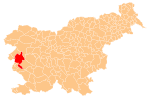
Ravnica
Location in Slovenia
Coordinates: 45°58′53.18″N13°41′50.9″E / 45.9814389°N 13.697472°E / 45.9814389; 13.697472
Country Flag of Slovenia.svg Slovenia
Traditional region Slovenian Littoral
Statistical region Gorizia
Municipality Nova Gorica
Area
  Total 7.3 km2 (2.8 sq mi)
Elevation 423 m (1,388 ft)
Population (2002)
  Total 225
[1]

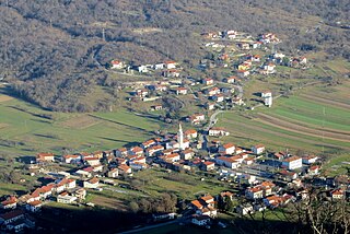
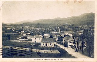
Ravnica (pronounced  [ɾau̯ˈniːtsa] ; Italian : Raunizza) is a village in western Slovenia in the Municipality of Nova Gorica. It is located on the high Trnovo Forest Plateau (Slovene : Trnovski gozd), overlooking the villages of Grgar and Čepovan. [2]

Italian language Romance language

Italian is a Romance language of the Indo-European language family. Italian, together with Sardinian, is by most measures the closest language to Vulgar Latin of the Romance languages. Italian is an official language in Italy, Switzerland, San Marino and Vatican City. It has an official minority status in western Istria. It formerly had official status in Albania, Malta, Monaco, Montenegro (Kotor) and Greece, and is generally understood in Corsica and Savoie. It also used to be an official language in the former Italian East Africa and Italian North Africa, where it plays a significant role in various sectors. Italian is also spoken by large expatriate communities in the Americas and Australia. Many speakers of Italian are native bilinguals of both standardized Italian and other regional languages.

Village Small clustered human settlement smaller than a town

A village is a clustered human settlement or community, larger than a hamlet but smaller than a town, with a population ranging from a few hundred to a few thousand. Though villages are often located in rural areas, the term urban village is also applied to certain urban neighborhoods. Villages are normally permanent, with fixed dwellings; however, transient villages can occur. Further, the dwellings of a village are fairly close to one another, not scattered broadly over the landscape, as a dispersed settlement.

Slovenia republic in Central Europe

Slovenia, officially the Republic of Slovenia, is a sovereign state located in southern Central Europe at a crossroads of important European cultural and trade routes. It is bordered by Italy to the west, Austria to the north, Hungary to the northeast, Croatia to the southeast, and the Adriatic Sea to the southwest. It covers 20,273 square kilometers (7,827 sq mi) and has a population of 2.07 million. One of the successor states of the former Yugoslavia, Slovenia is a parliamentary republic and a member of the United Nations, of the European Union, and of NATO. The capital and largest city is Ljubljana.

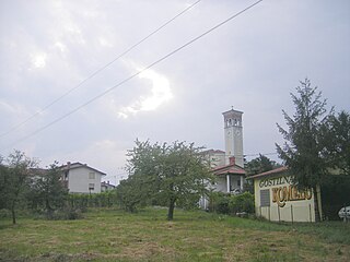
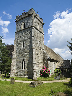
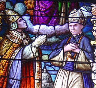
The parish church in the settlement is dedicated to Saints Hermagoras and Fortunatus and belongs to the Diocese of Koper. [3]

Parish church church which acts as the religious centre of a parish

A parish church in Christianity is the church which acts as the religious centre of a parish. In many parts of the world, especially in rural areas, the parish church may play a significant role in community activities, often allowing its premises to be used for non-religious community events. The church building reflects this status, and there is considerable variety in the size and style of parish churches. Many villages in Europe have churches that date back to the Middle Ages, but all periods of architecture are represented.

Hermagoras of Aquileia Bishop of Aquileia

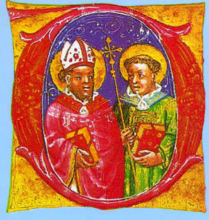
Saint Hermagoras of Aquileia is considered the first bishop of Aquileia, northern Italy. Christian tradition states that he was chosen by Saint Mark to serve as the leader of the nascent Christian community in Aquileia, and that he was consecrated bishop by Saint Peter. Hermagoras and his deacon Fortunatus evangelized the area but were eventually arrested by Sebastius, a representative of Nero. They were tortured and beheaded.

Diocese Christian district or see under the supervision of a bishop

The word diocese is derived from the Greek term dioikesis (διοίκησις) meaning "administration". Today, when used in an ecclesiastical sense, it refers to the ecclesiastical district under the jurisdiction of a bishop.

Related Research Articles

University of Primorska university

University of Primorska is the third university in Slovenia. It is located in Koper, Izola, and Portorož and is named for the Slovenian Littoral region, where it is located.

Ozeljan, Nova Gorica Place in Slovenian Littoral, Slovenia

Ozeljan is a village in the lower Vipava Valley in western Slovenia. It is part of the Municipality of Nova Gorica in the Gorizia region of the Slovenian Littoral.

Banjšice Place in Slovenian Littoral, Slovenia

Banjšice is a settlement in western Slovenia in the Municipality of Nova Gorica. It has a population of 264. It is located on the high Banjšice Plateau, overlooking the Soča Valley. It is made up of several hamlets, including Breg, Lohke, Ošlakarji, Mrcinje, Trušnje, Podlešče, Raven, Kuščarji, and Krvavec.

Roman Catholic Diocese of Koper diocese of the Catholic Church

The Roman Catholic Diocese of Koper is a diocese in southwestern Slovenia. It is part of the Ecclesiastical province of Ljubljana. Its cathedral is dedicated to the Assumption of Mary and is located in the Adriatic port town of Koper. A co-cathedral, the Co-Cathedral of Christ the Saviour, located in Nova Gorica, gained its status in 2004. The Latin name of the diocese, Dioecesis Iustinopolitanus, is due to the fact that Koper was in the past name Justinopolis in honour of the Byzantine emperor Justinian II.

Bate, Nova Gorica Place in Slovenian Littoral, Slovenia

Bate is a village in western Slovenia in the Municipality of Nova Gorica. It is located on the Banjšice Plateau. It is part of the Gorizia area of the wider traditional region of the Slovenian Littoral, and is now part of the Gorizia Statistical Region. It includes the hamlets of Dolenji Konec, Gorenji Konec, Na Placu, and Breščaki in the main settlement, as well as Čafarini, Humarji, Sveto, Ježevec, Madoni, Jelaršče, Pičulini, Podlaka, Sedevčiči, and Čeferinovšče.

Grgar Place in Slovenian Littoral, Slovenia

Grgar is a village in western Slovenia in the Municipality of Nova Gorica. It is located under Holy Mount, above the Soča Valley and below the Banjšice Plateau.

Kromberk Place in Slovenian Littoral, Slovenia

Kromberk is a settlement in the City Municipality of Nova Gorica in western Slovenia. Together with its two satellite settlements of Ajševica and Loke, it forms one of the four major suburbs of Nova Gorica.

Loke, Nova Gorica Place in Slovenian Littoral, Slovenia

Loke is a dispersed settlement in the Municipality of Nova Gorica in western Slovenia. It is located on the lowest edge of the Vipava Valley, just beneath the high Trnovo Forest Plateau. It is a satellite settlement of Kromberk, one of the four suburbs of Nova Gorica.

Lokovec Place in Slovenian Littoral, Slovenia

Lokovec is a dispersed settlement in western Slovenia in the Municipality of Nova Gorica. It is located on the Banjšice Plateau overlooking the narrow Čepovan Valley, which divides it from the Trnovo Forest Plateau on the other side of the valley. It is part of the Gorizia region.

Lokve, Nova Gorica Place in Slovenian Littoral, Slovenia

Lokve is a village in western Slovenia in the Municipality of Nova Gorica. It is located in the Trnovo Forest, above the Vipava Valley in the Gorizia region of the Slovene Littoral. It is a popular tourist center, serving as a summer resort for people from the towns of Nova Gorica and Gorizia (Italy). Škol Hill rises north of Lokve.

Osek, Nova Gorica Place in Slovenian Littoral, Slovenia

Osek is a village in western Slovenia in the Municipality of Nova Gorica. It is located in the Vipava Valley in the Gorizia region of the Slovene Littoral.

Preserje, Nova Gorica Place in Slovenian Littoral, Slovenia

Preserje is a village in western Slovenia in the Municipality of Nova Gorica. It has a population of 457. It is located in the low hills above the settlement of Branik in the Vipava Valley.

Trnovo, Nova Gorica Place in Slovenian Littoral, Slovenia

Trnovo is a village in western Slovenia in the Municipality of Nova Gorica. It is located on the high Trnovo Forest Plateau in the traditional Slovene Littoral region.

Vitovlje, Nova Gorica Place in Slovenian Littoral, Slovenia

Vitovlje is a small village above Šempas in the Municipality of Nova Gorica in western Slovenia. It is located in the lower Vipava Valley in the Gorizia region of the Slovene Littoral.

Gradišče nad Prvačino Place in Slovenian Littoral, Slovenia

Gradišče nad Prvačino is a village in western Slovenia in the Municipality of Nova Gorica. It is located in the Vipava Valley in the Gorizia region and is a satellite settlement of Prvačina.

Prvačina Place in Slovenian Littoral, Slovenia

Prvačina is a village in the Vipava Valley in western Slovenia. It lies within the Municipality of Nova Gorica.

Šempas Place in Slovenian Littoral, Slovenia

Šempas is a village in the Vipava Valley in the Municipality of Nova Gorica in western Slovenia.

Zalošče Place in Slovenian Littoral, Slovenia

Zalošče is a village in western Slovenia in the Municipality of Nova Gorica. It is located in the lower Vipava Valley in the Gorizia region of the Slovene Littoral.

Pedrovo Place in Slovenian Littoral, Slovenia

Pedrovo is a settlement in the City Municipality of Nova Gorica, western Slovenia. It was established in 2011. Previously, it was part of the settlement of Branik. On 1 January 2012, it had an area of 1.5 square kilometres (0.58 sq mi) and 12 inhabitants.

The Co-Cathedral of Christ the Saviour, also called Nova Gorica Cathedral, is the name given to a religious building that is affiliated with the Catholic Church and serves as the co-cathedral or alternate cathedral of the Diocese of Koper. It is located in Nova Gorica, a city in the European country of Slovenia. It was built in 1982 by architect Franc Kvaternik project. Inside the image of Christ and the cross made of wood, painted by Stane Jarm.

References

Coordinates: 45°59′N13°42′E / 45.983°N 13.700°E / 45.983; 13.700

Geographic coordinate system Coordinate system

A geographic coordinate system is a coordinate system that enables every location on Earth to be specified by a set of numbers, letters or symbols. The coordinates are often chosen such that one of the numbers represents a vertical position and two or three of the numbers represent a horizontal position; alternatively, a geographic position may be expressed in a combined three-dimensional Cartesian vector. A common choice of coordinates is latitude, longitude and elevation. To specify a location on a plane requires a map projection.