Red Brick Roads

Last updated
Historic Star Route
Historic Star Route - NE Maple St. Historic Star Route- NE Maple St..jpg
Historic Star Route - NE Maple St.
Star Route leading up to the United Presbyterian Church & Pullman Christian Church. United Presbyterian Church & Pullman Christian Church.jpg
Star Route leading up to the United Presbyterian Church & Pullman Christian Church.
NE Maple Street, north view. (close-up) NE Maple Street, north view. (close-up).jpg
NE Maple Street, north view. (close-up)

The Red Brick Roads, in Pullman, Washington, are a block of NE Maple St. and a block of NE Palouse St. and together are the last remaining brick streets in the city. In 2014, the roads were listed on the National Register of Historic Places. [1] The roads, paved in 1913, are important landmarks because they made transportation easier along the only of the city's Star routes, providing an essential connection between the Northern Pacific Railroad depot and the growing campus of Washington State College (now known as Washington State University). The steepest part of the route to campus (which included the block of what is today NE Maple St. and NE Palouse St.) received brick paving to provide traction for horses and automobiles—particularly during the difficult winter months.

Contents

Transportation context

Beginning in 1885, the railroad served as a vital communication and transportation link to the growing region. Pullman housed two railroad depots, the Northern Pacific Railway and the Oregon Railroad and Navigation Company (OR&N, most recently known as Union Pacific). The red brick street was built near the Northern Pacific Railway Depot as padding around the tracks for the pedestrians. Growing interest in the Palouse region led Northern Pacific Immigration officials to visit Pullman in the summer of 1913 and they were very impressed with the college campus and city, remarking that they were "sending immigrants to a paradise." [2] Due to the rapid growth and awareness of the region's significance, in 1917, Northern Pacific paid $40,000 for a "modern" facility, replacing the original depot. The pad was increased and laid in vitrified brick to match the adjacent "Palouse" or "Star Route" Street. [3] The railroad was the only means of travel that allowed people and students to leave and reenter the town during the late 1800s, and the Northern Pacific Railway and the OR&N ran special trains that allowed the students to leave school for breaks. Starting in the second decade of the twentieth century, automobiles began to dominate the landscape. Highways were built in the region, reducing the region's dependence on the railroad. In 1970, acquiescing to the automobiles dominance as a people-mover, Northern Pacific halted the use of passenger trains. [4]

"Historic Star Route"

Part of the Red Brick Roads was a Star route. Star routes were affiliated with the United States Postal Service and were distinguished as old mail routes that were also commonly known as Highway Contract Routes for delivering mail. From the Northern Pacific Railroad depot, the red brick paving continued up to Star Route St. (now known as Maple St.) to Montgomery St. (today known as Campus St.) then east to the center of the college. Star Route was a very dusty and muddy horse and buggy road during the early 1900s. During the winter it was very difficult to travel and in 1906 a wooden sidewalk was constructed to aid foot traffic. On February 9, 1907 the Pullman Herald wrote concerning the safety of Star Route: "[It is] the most dangerous road in the county… there is an almost perpendicular drop off of 18-20 feet with the Northern Pacific Track lying beneath. If a team should run away on coming down Star Route it would in all probability dash over the yawning precipice and death would be inevitable". [5] The city and residents of Pullman saw paving as a solution to the dangers and inefficiencies of the unpaved dirt road.

Funding the roads

Automobiles accompanied horse carriages in Pullman by 1912. The high traffic streets were used by both automobiles and horses, which required the streets to be surfaced. The Pullman Chamber of Commerce played an early role in establishing the importance of paved streets by forming the Pullman Good Roads Committee in 1911. The Pullman Good Roads Committee immediately began formation of a plan to pave a route to be determined from the preexisting streets from the city to the college. The properties adjacent to the roads paved would be responsible to pay taxes and in addition, the college and community businesses would help fund the project as well. The Good Roads Committee advocated for new roads and helped the college receive the Mill Tax (an early form of property tax), which increased revenue to the college to allow them to expand and improve the campus. The roads benefited the local economy by allowing deliverymen to reduce prices for customers because they could operate year round. [6] The route was chosen through College Hill because it was the lowest slope of the several city to campus routes. [7] The preferred paving surface was Macadam and concrete curbing; brick was used on high sloped sections of the streets to help horses get traction to climb up the hills. Due to the increasing enrollment to the college and population growth of the city, the roads had a significant amount of automobile and carriage traffic by the time they were paved. The lack of speed limits on automobiles soon became an issue after the paving was placed and on May 23, 1913, Pullman addressed the speed issue and passed an ordinance to limit the speed to 12 mph for automobiles and horses. [8]

College campus context

The presence and growth of Washington State College (today known as Washington State University), inspired Pullman citizens to clamor for the paving of the city's historic star route. The first streets that were paved on College Hill began at the Northern Pacific Railroad depot across from Palouse street. The high traffic areas of Pullman required paving for horses, mail routes, and for some of the first automobiles. In 1912, to meet the growing needs on the transportation infrastructure, Pullman implemented street improvements. [9] The street was and remains a significant avenue for the campus, for it increased the efficiency and access to transportation by carriage and eventually by automobile, allowing generations of students to attend class.

Spiritual surroundings

The Red Brick Roads have a connection to Pullman's spiritual community, for Pullman's first Presbyterian church chose to locate along them. In the late 1890s, President Enoch A. Bryan of Washington State College called for a church where students could worship. He purchased land on Star Route and led the drive to build Pullman's first Presbyterian church—completed in 1899 at a cost of $4,000. The money came partly from Dr. W. A. Spalding of the First United Presbyterian Church of Spokane, Washington, plus monies that Bryan raised in the community. Within fifteen years the rapid growth of the college and the Pullman community necessitated the construction of a larger church. In 1914, the old church was lifted, rotated, and incorporated into a new structure clad in Tenino stone. The new church was praised by the Pullman Herald as a "permanent and lasting piece of art which speaks well of the city." [10] Following a renovation and reconfiguration in the mid-2000s, the former church is now a multi-unit dwelling knowns as the Greystone Apartments, with some of the original wooden trusswork and stained glass still visible. The structure, which is listed on the National Register of Historic Places, is a substantial presence at the northern edge of the Red Brick Roads.

The original Pullman Hospital

In 1912, the first hospital was built along the brick roads—specifically along what was officially called Star Route. Originally named "Campbell's Hospital" with the address of 1507 Star Route, it is currently located on the corner of Campus St. and Maple St. However, in 1912 Dr. Campbell renovated it and renamed it "The Pullman Hospital." The hospital originally operated as a private facility, but after renovation it was converted to a public hospital. Historically, the Red Brick Roads played a vital role in assisting the transportation of patients to the hospital.

Related Research Articles

<span class="mw-page-title-main">Moscow, Idaho</span> City in northern Idaho, United States

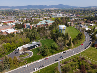
Moscow is a city and the county seat of Latah County, Idaho. Located in the North Central region of the state along the border with Washington, it had a population of 25,435 at the 2020 census. Moscow is the home of the University of Idaho, the state's land-grant institution and primary research university.

<span class="mw-page-title-main">Pullman, Washington</span> City in Washington, United States

Pullman is the largest city in Whitman County, located in southeastern Washington within the Palouse region of the Pacific Northwest. The population was 29,799 at the 2010 census, and estimated to be 34,506 in 2019. Originally founded as Three Forks, the city was renamed after industrialist George Pullman in 1884.

<span class="mw-page-title-main">Milwaukee Road</span> Class I railroad that operated in the Midwest and Northwest of the United States

The Chicago, Milwaukee, St. Paul and Pacific Railroad (CMStP&P), better known as the Milwaukee Road, was a Class I railroad that operated in the Midwest and Northwest of the United States from 1847 until 1986.

<span class="mw-page-title-main">Washington State Route 522</span> Highway in Washington state

State Route 522 (SR 522) is a state highway in the U.S. state of Washington that serves the Seattle metropolitan area. Approximately 25 miles (40 km) long, it connects the city of Seattle to the northeastern suburbs of Kenmore, Bothell, Woodinville, and Monroe. Its western half is primarily an arterial street, named Lake City Way and Bothell Way, that follows the northern shore of Lake Washington; the eastern half is a grade-separated freeway that runs between Woodinville and Monroe. SR 522 connects several of the metropolitan area's major highways, including Interstate 5 (I-5), I-405, SR 9, and U.S. Route 2 (US 2).

<span class="mw-page-title-main">Minnesota Transportation Museum</span> Transportation museum in Saint Paul, Minnesota

The Minnesota Transportation Museum is a transportation museum in Saint Paul, Minnesota, United States.

<span class="mw-page-title-main">U.S. Route 195</span> U.S. Highway in Washington (state) and Idaho in the United States

U.S. Route 195 (US 195) is a north–south United States Highway, of which all but 0.65 miles of its 94.02 miles are within the state of Washington. The highway starts in rural Idaho north of the city of Lewiston as a state highway in an interchange with US 95. As the road crosses into Washington it becomes a state highway that connects communities in the Palouse region of Eastern Washington. US 195 travels north, serving the cities of Pullman, Colfax and Rosalia in Whitman County before continuing into Spokane County to its terminus in the city of Spokane at an interchange with Interstate 90 (I-90).

<span class="mw-page-title-main">Saint Paul Union Depot</span> Train station in Saint Paul, Minnesota

Saint Paul Union Depot is a historic railroad station and intermodal transit hub in the Lowertown neighborhood of the city of Saint Paul, Minnesota, United States. It serves light rail, intercity rail, intercity bus, and local bus services.

<span class="mw-page-title-main">Mullan Road</span> United States historic place

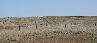
Mullan Road was the first wagon road to cross the Rocky Mountains to the Inland of the Pacific Northwest. It was built by U.S. Army troops under the command of Lt. John Mullan, between the spring of 1859 and summer 1860. It led from Fort Benton, which at the time was in the Dakota Territory, then Idaho Territory from July 1863, and into Montana Territory beginning in May 1864. The road eventually stretched all the way from Fort Walla Walla, Washington Territory, near the Columbia River to the navigational head of the Missouri River, which at the time was the farthest inland port in the world). The road previewed the route approximately followed by modern-day Interstate 15 and Interstate 90 through present-day Montana, Idaho, and Washington.

<span class="mw-page-title-main">Washington State Route 27</span> Highway in Washington, United States

State Route 27 (SR 27) is a 90-mile-long (145 km) state highway serving Whitman and Spokane counties, located in the eastern region of the U.S. state of Washington. The highway travels generally north from U.S. Route 195 (US 195) through Pullman, Palouse, Tekoa, and Spokane Valley to SR 290 north of an interchange with Interstate 90 (I-90). SR 27 serves the Palouse region as part of the Palouse Scenic Byway and travels between US 195 to the west and US 95 to the east in Idaho, with several auxiliary routes connecting to the two other highways.

<span class="mw-page-title-main">Washington State Route 26</span> State highway in Washington, United States

State Route 26 (SR 26) is a state highway in central Washington in the United States. It travels east–west for 114 miles (183 km) from Interstate 90 (I-90) near Vantage to U.S. Route 195 (US 195) in Colfax. The highway intersects several major north–south highways, including SR 24, SR 17, US 395, and SR 261 before ending in Colfax. The route serves as a connector between Vantage, Royal City, Othello, Washtucna, La Crosse, and Colfax.

<span class="mw-page-title-main">Palouse to Cascades State Park Trail</span>

The Palouse to Cascades State Park Trail, formerly known as the John Wayne Pioneer Trail and the Iron Horse Trail, is a rail trail that spans most of the U.S. state of Washington. It follows the former railway roadbed of the Chicago, Milwaukee, St. Paul & Pacific Railroad for 300 miles (480 km) across two-thirds of the state, from the western slopes of the Cascade Mountains to the Idaho border.

<span class="mw-page-title-main">Washington State Route 270</span>

State Route 270 (SR 270) is a state highway in Whitman County, Washington, United States. It connects the city of Pullman to U.S. Route 195 (US 195) at its west end and Idaho State Highway 8 near Moscow, Idaho, at its east end. The 10-mile-long (16 km) highway is one of the main roads in Pullman and connects the campuses of Washington State University and the University of Idaho.

<span class="mw-page-title-main">Idaho State Highway 8</span> State highway in Idaho, United States

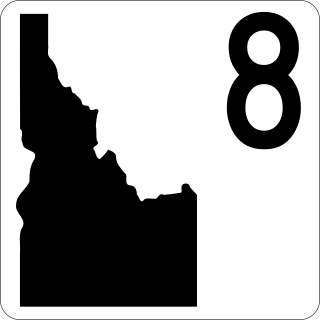
State Highway 8 (SH-8) is an Idaho state highway in Latah and Clearwater counties, running from the Washington state line in Moscow to Elk River. It is 53.589 miles (86.24 km) in length, and runs primarily east–west.

<span class="mw-page-title-main">Minneapolis Great Northern Depot</span> Demolished train station in Minnesota

The Minneapolis Great Northern Depot, also known as Great Northern Station, was a passenger railroad station which served Minneapolis, Minnesota, USA. It was built in 1913 and demolished in 1978. It was located on Hennepin Avenue next to the Hennepin Avenue Bridge and across the street from the main Minneapolis Post Office.

<span class="mw-page-title-main">Transportation in Omaha</span>

Transportation in Omaha, Nebraska, includes most major modes, such as pedestrian, bicycle, automobile, bus, train and airplane. While early transportation consisted of ferries, stagecoaches, steamboats, street railroads, and railroads, the city's transportation systems have evolved to include the Interstate Highway System, parklike boulevards and a variety of bicycle and pedestrian trails. The historic head of several important emigrant trails and the First transcontinental railroad, its center as a national transportation hub earned Omaha the nickname "Gate City of the West" as early as the 1860s.

<span class="mw-page-title-main">Washington State Route 272</span>

State Route 272 (SR 272) is a 19.22-mile (30.93 km) long state highway serving Whitman County in the U.S. state of Washington. The highway travels from U.S. Route 195 (US 195) in Colfax to a short concurrency with parent route SR 27 in Palouse before ending at the Idaho state line and becoming Idaho State Highway 6 (SH-6). Prior to 1964, the highway was split between Secondary State Highway 3F (SSH 3F) from Colfax to Palouse and a branch of Primary State Highway 3 (PSH 3) from Palouse to the Idaho state line.

<span class="mw-page-title-main">Reed and Stem</span> American architectural and engineering firm

Reed and Stem is an American architectural and engineering firm. The firm was founded in St. Paul, Minnesota in 1891 as a partnership between Charles A. Reed (1858–1911) and Allen H. Stem (1856–1931), the successful partnership captured a wide range of commissions. The firm was reformed as Wank Adams Slavin Associates in 1961, and adopted the name WASA Studio in 2004.

The Washington and Idaho Railway was a shortline railroad that operated in the area south of Spokane, Washington, connecting the BNSF Railway at Marshall to Palouse, Washington, Harvard, Idaho, and Moscow, Idaho. It began operations in 2006 on ex-Northern Pacific Railway and Washington, Idaho and Montana Railway trackage formerly operated by the Palouse River and Coulee City Railroad, which had acquired it from the Burlington Northern Railroad in 1996. The railroad ceased operations in 2019 as a new operator gained control of the line.

<span class="mw-page-title-main">Sett (paving)</span> Rectangular stone for surfacing roads and walkways

A sett, also known as a block or Belgian block, is a broadly rectangular quarried stone used in paving roads and walkways. Formerly in widespread use, particularly on steeper streets because setts provided horses' hooves with better grip than a smooth surface, they are now encountered rather as decorative stone paving in landscape architecture. Setts are often referred to as "cobblestones", although a sett is distinct from a cobblestone in that it is quarried or worked to a regular shape, whereas the latter is generally a small, naturally-rounded rock. Setts are usually made of granite.

The Bill Chipman Palouse Trail is a paved rail trail in the northwestern United States, from Pullman, Washington, eastward to Moscow, Idaho. Completed 25 years ago in 1998, it follows the former Union Pacific Railroad right-of-way and connects the rural university towns on the Palouse across the state border.

References

  1. National Park Service. "Star Route and Palouse Street Brick Roads".
  2. "Northern Pacific Immigration Officials Pleased With Pullman". Pullman Herald. August 22, 1913.
  3. "$40,000 Northern Pacific Depot Comes To Pullman". Pullman Herald. May 5, 1916.
  4. "Brief Local News". Pullman Herald. December 23, 1921. Retrieved March 3, 2013.
  5. "Editorial". Pullman Herald. Feb 9, 1907. Retrieved March 3, 2013.
  6. "Dr. Egge's Theories on Paving". Pullman Herald. December 19, 1913. Retrieved March 3, 2013.
  7. "Road To College Will Be Paved". Pullman Herald. February 3, 1911. Retrieved March 3, 2013.
  8. "Pullman, Wa". Ordinance No. 240. 1913.
  9. James, Lindsay (1923). An Economic History of Whitman County, Washington. Pullman, WA: Washington State University.
  10. Evans, Michael, Greystone Church and Foundation Records, Washington State University Libraries Manuscripts, Archives, and Special Collections

46°43′50″N117°10′40″W / 46.7305°N 117.1779°W / 46.7305; -117.1779