Red Line, Iowa | |
|---|---|
 Red Line Church of Christ | |
 Red Line, Iowa | |
| Coordinates: 41°43′02″N95°09′04″W / 41.71722°N 95.15111°W | |
| Country | United States |
| State | Iowa |
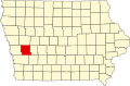
| County | Shelby |
| Elevation | 1,266 ft (386 m) |
| Time zone | UTC-6 (Central (CST)) |
| • Summer (DST) | UTC-5 (CDT) |
| Area code | 712 |
| GNIS feature ID | 460552 [1] |
Red Line is an unincorporated community in Polk Township, Shelby County, Iowa, United States. [1]