
The Ontario Northland Railway is a Canadian railway operated by the Ontario Northland Transportation Commission, a provincial Crown agency of the government of Ontario.

Bradford is the primary country urban area of the Town of Bradford West Gwillimbury, Ontario, in Canada. It overlooks a farming community, known as The Holland Marsh, located on the Holland River that flows into Lake Simcoe.

Nickel Centre was a town in Ontario, Canada, which existed from 1973 to 2000.
Pakesley is a dispersed rural community and ghost town in geographic Mowat Township in the Unorganized Centre Part of Parry Sound District of Ontario, Canada. Located at the junction of Ontario Highway 522 and the Parry Sound subdivision of the Canadian Pacific Railway, it is named for the Pakeshkag River that drains the local area north to the Pickerel River. Formerly a station and passing track on the CPR, this portion of the line from Bala to Sudbury was opened to traffic June 15, 1908.
Lost Channel is a ghost town in Parry Sound District, Ontario.

Biscotasing, often referred to as simply Bisco, is a community in the Unorganized North Part of Sudbury District in Northeastern Ontario, Canada. It was founded on the shores of Lake Biscotasi on the Spanish River in 1884 by Canadian Pacific Railway as a railway construction town, and the first divisional point west of Sudbury. The rails of westward track laying gangs reached this area in October 1884.
Nairn and Hyman is a township in the Canadian province of Ontario. The township, located in the Sudbury District, borders on the southwestern city limits of Greater Sudbury west of the city's Walden district. The township had a population of 342 in the Canada 2016 Census.

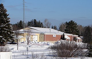
Temagami, formerly spelled as Timagami, is a municipality in northeastern Ontario, Canada, in the Nipissing District with Lake Temagami at its heart.

Temagami North, formerly known as Goward, is a community comprising part of the municipality of Temagami in Nipissing District, Ontario, Canada. It is a residential subdivision centred on Spruce Drive, about 5 kilometres (3.1 mi) north of Temagami itself.

Ear Falls is a township located in Northwestern Ontario, Canada, on the banks of the English River, Lac Seul, Pakwash Lake and Wenesaga Lake. It is located along Highway 105, 100 kilometres (62 mi) north of Highway 17 and Vermilion Bay, about halfway between Highway 17 and Red Lake, or about 480 kilometres (300 mi) northwest of Thunder Bay.

Chamberlain is a township in the Canadian province of Ontario, located within the Timiskaming District.
Raspberry is an unincorporated community in the West Kootenay region of southeastern British Columbia. On the northeast side of the Columbia River adjacent to the mouth of Norns Creek, the residential area is part of Greater Castlegar.
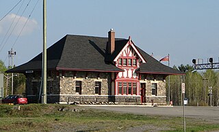
Temagami station is a railway station in Temagami, Ontario, Canada.
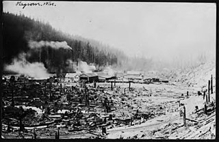
Nagrom was a town in King County, Washington, United States. A logging company town, Nagrom was located in the Green River watershed between Kanaskat and Lester. The town was built by the Morgan Lumber Company and named after Elmer G. Morgan, the company founder and owner. The site was chosen for its access to timber and suitability to build a sawmill and mill pond. In 1910, Morgan petitioned the Northern Pacific Railway, which operated the rail line out of Puget Sound and up over Stampede Pass, to build a spur into the small town. The railway balked, but Morgan persisted and eventually the railway relented. The spur into town was built in 1911. A post office was established that same year, along with a telephone and telegraph exchange.

The Milne Townsite, commonly referred to as Milnes, is an abandoned community in Strathy Township, municipality of Temagami, Nipissing District in northeastern Ontario, Canada, located on the north shore of Link Lake, just south of the Milne-Sherman Road, and about 2 km (1.2 mi) north of the town of Temagami. It covered about 3.5% of the town of Temagami and had 40 residents.

Upper Redwater Lake is a narrow freshwater lake in the municipality of Temagami of Northeastern Ontario, Canada, located southeast of the former Rabbit Creek ballast pit along Rabbit Creek Road that comes out at Highway 11. The settlement of Redwater is located on the southeastern shore of Upper Redwater Lake and the Ontario Northland Railway mainline runs along its entire western shore. Its northern end is crossed by the Ontario Northland Railway where the lake sways northeastwards. At the southern end of the lake is a strait that connects Upper Redwater Lake with Lower Redwater Lake.
Owaissa is an unincorporated place and railway point in the municipality of Temagami, Nipissing District, in Northeastern Ontario, Canada. It is in geographic Strathy Township, and is located on Ontario Highway 11, on the Ontario Northland Railway, and on the northern arm of Net Lake, about 3 km (1.9 mi) north of
Doherty is an unincorporated place and railway point in the municipality of Temagami, Nipissing District, Northeastern Ontario, Canada. It is in geographic Riddell Township and is located at the southwestern corner of Lower Twin Lake on the Ontario Northland Railway. Doherty is at Mileage 63.4 and was the location of a train station in the 1940s.
Rabbit Creek is a stream in the municipality of Temagami, Nipissing District, Northeastern Ontario, Canada. It is in the Ottawa River drainage basin and originates from an unnamed pond north of Christy Lake in geographic Law Township. From there it flows north then turns east to North Milne Lake. It heads northeast under Highway 11 to an unnamed lake, passes into geographic Askin Township, reaches Hornet Lake and takes in the right tributary Angus Creek where it travels along the Ontario Northland Railway to its mouth at Rabbit Lake. Rabbit Lake flows via the Matabitchuan River and Lake Timiskaming to the Ottawa River.
The Canadian National Railway Alderdale Subdivision was a railway line in Northeastern Ontario, Canada. It originally opened in 1915 as a part of the Canadian Northern Railway's transcontinental mainline. It connected Brent in the east with Capreol in the west. At Capreol it formed the eastern component of an east-west-south wye junction. The line's divisional point was at Alderdale.


