Casco Township is a civil township of Allegan County in the U.S. state of Michigan. The population was 2,796 at the 2020 census.

Chesterfield Charter Township is a charter township of Macomb County in the U.S. state of Michigan. As of the 2020 census the population was 45,376.
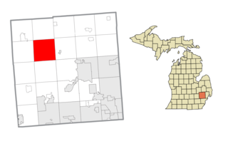
Springfield Charter Township is a charter township of Oakland County in the U.S. state of Michigan. As of the 2020 census, the township population was 14,703. The township was named for the numerous springs in the area.
Paris Springs Junction is a small unincorporated community in Lawrence County, Missouri, United States. It lies along former U.S. Route 66, four miles (6 km) west of Halltown. Paris Springs Junction started as a few businesses on Route 66 and, with the decommissioning of that highway, has now become only homes. It was so named because of a former town named Paris Springs to the north. That town was founded in 1855 and survived until the time of Route 66's decommissioning.
Rueter is an extinct town in southeastern Taney County, Missouri. The GNIS classifies it as a populated place. The town site is located at western intersection of U.S. Route 160 and Route 125. Rueter is part of the Branson, Missouri Micropolitan Statistical Area.

Walnut Shade is an unincorporated community in Taney County, Missouri, United States. It is located approximately six miles northwest of Forsyth on U.S. Route 160. The town sits at the confluence of Bull and Bear Creeks. Walnut Shade is part of the Branson, Missouri Micropolitan Statistical Area. The ZIP Code for Walnut Shade is 65771.
Jenkins is an unincorporated community in Barry County, Missouri, United States. It is located on Route 39, just north of Route 248, approximately twelve miles northeast of Cassville. Jenkins Creek flows through the community and its confluence with Flat Creek is just to the south.

Wheelerville is an unincorporated community in northeastern Barry County, Missouri, United States. It is located at the intersection of Route 248 and Route D, approximately eight miles west-northwest of Galena in adjacent Stone County.
Minden is a ghost town in Lawrence County, Missouri, United States. It possessed a post office from 1860 to 1873.
Doddridge is an unincorporated community in southern Miller County, Arkansas, United States, approximately five miles north of the Louisiana border. Doddridge is located at the junction of Arkansas Highway 160 and U.S. Route 71, and I-49 passes through the area, connecting it to Texarkana and Louisiana, as well as the confluence of the Sulphur and Red rivers. Although unincorporated, Doddridge has a post office, with the ZIP code of 71834.
Highway City is an unincorporated community in Fresno County, California. It is located 2.5 miles (4 km) southeast of Herndon, at an elevation of 299 feet.
Scholten is an unincorporated community in northeast Barry County, Missouri, United States, located approximately 16 miles (26 km) northeast of Cassville. Scholten is located on Missouri Route D one mile north of Wheelerville and Missouri Route 248. Its elevation is 1,378 feet (420 m).

Dolph is an unincorporated community in Tillamook County, Oregon, United States, near the Yamhill County line. It lies at the junction of Oregon Route 22 and Oregon Route 130 between Grande Ronde and Hebo, on the Little Nestucca River. It is within the Siuslaw National Forest in the Northern Oregon Coast Range.
Silverton is an historic town in Douglas County, Missouri, United States. The GNIS classifies it as a populated place. It was located along County Road 317 on Spring Creek, 1.7 miles (2.7 km) north-northeast of Wasola and 1.9 miles (3.1 km) west of the Hilo Cemetery, along Route N on Hilo Ridge. Although Hilo is listed as a variant name, the two were not at the same location.
Fay is an unincorporated community in southeastern Ozark County, in the Ozarks of south-central Missouri, United States. The community is located along Missouri Route J, approximately 2.5 miles south of U.S. Route 160. The Fay Cemetery lies just west of Route J and north of the Lick Creek - Sweeten Creek junction.
Luna is an extinct town in Ozark County, in the U.S. state of Missouri. The GNIS classifies it as a populated place. The community is on a ridge between Bryant Creek to the east and Pine Creek to the west and is located on Missouri Route FF. Zanoni, on Missouri Route 181, lies approximately two miles to the northwest. The community church is one and one-half miles west on Caney Creek and Missouri Route AA. The Pine Creek confluence with Bryant Creek is one and one-quarter miles to the south, at the north end of Norfork Lake.
Thuroy is an unincorporated community in Ozark County, Missouri, United States. The village was located on a northward-flowing tributary to Barren Creek, approximately one-half mile from the Missouri-Arkansas border and Missouri State Highway 101. Bakersfield is about four miles to the northeast. Barren Creek flows into Norfork Lake in Arkansas, approximately four miles to the southwest.
Iuka Springs is an extinct town in St. Clair County, in the U.S. state of Missouri. The GNIS classifies it as a populated place.
Abesville is an unincorporated community in east central Stone County, in the U.S. state of Missouri. Abesville is located on Missouri Route 176, approximately two miles west of U.S. Route 160 and the Stone – Christian county line.
Carico is an unincorporated community in Stone County, in the U.S. state of Missouri. Carico is located at the junction of Railey Creek and Carico Hollow, approximately 3.5 miles east-southeast of Galena and 6.5 miles northwest of Reeds Spring along the Missouri Pacific Railroad.

