Reichenbach lies in the "Middle Bavarian Forest", in the middle Regental, in the valley of the river rain. (For the history of the well over 1000-year history Reichenbacher would be "Front Šumava" more precise.)
Neighboring communities
In the north and east: community Walderbach. In the south: community forest In the West: City Nittenau (Lkr. Schwandorf)
Parts of the community
Reichenbach, (dialect: from [raichawoch] to [raichaboch]) since 1118th Earlier Placenames: 1122 Richinbach; 1283 Richenwach; 1317 Reichennbach; 1392 Reychenbach. The closest explanation for the name Reichenbach: Settled on rich stream. The importance of water-rich probably not come into question, since this "stream" in the dry season was almost waterless, so this leaves only the importance of "fish-rich stream." The fishing in the rain played in earlier centuries when the great needs of the nearby monasteries and the many meatless days, a far greater role than today.
Kienleiten is a district of the municipality. mundartlich: khüi (s) laitn / kinleitn since'1555. Earlier Placenames: Khuenleuthen or Khienleiten Statement by the city name: Old High German hilta, Lita, Middle High German lite the Leite, the mountain slope. The word chien (Old High German) means pine resin, pine, which Kienföhre. As it is a Bach or a birch Leite, so here a "Kienleite", a settlement on a hillside, with the pines, there is. Kienleiten was once owned by Walderbach.
Heimhof is a hamlet, Gemarkung Tiefenbach. mundartlich: haimhof since about'1125. Earlier Placenames: 1125 Heiminghoven; 1378 Heimhof; 1668 Haimbhoff; 1670 Heimhof. Statement by the city name: "In the courtyards, or at a yard Heimo, Haimo." The hamlet once belonged to the possession of the monastery Reichenbach.
Windhof is a hamlet, Gemarkung Tiefenbach. mundartlich: Windhof, Windin since'1249 '. Former name: 1667 Windahoff. Statement by the city name: The farm is located at the roof height by Roßbach high after the rain, the winds of any kind is totally open. Windhof is a courtyard in a particularly exposed to the winds agency.
Kaltenbach is a desert, Gemarkung Treidling. mundartlich: kholtbo / kholtboch since'1270 '. Former name: 1270 Chaltenbach, 1378, the Lo of the cold stream. Statement by the city name: The name was created by the stream "Kaltenbach", the Walderbacher from the forest and forest rises west of Reichenbach in the rain ends. The settlement in the cold creek.
Hochgart is a desert, Gemarkung Reichenbach. mundartlich: hougoat. Statement by the city name: From Old High German Garden "fenced land, fenced farm," but also "fencing, the garden." "High" indicates the situation on the high against the Regental Pfaffenstein running out. Settled in a garden protected by fencing or settlement on a farm protected by fencing. The desert belonged to the community forest Erbach and lies east of the monastery Reichenbach. Hochgart likely because of its proximity to the monastery Reichenbach once a part of the operation under its own standing monastery have been good.
Linden is a hamlet, Gemarkung Tiefenbach. mundartlich: Lintner / lindner since'1249 '. Earlier Placenames: 1249 Linda; 1498 Linter Veld and gründt. Statement by the city name: The tree and forest resources of the former forests were often the corridor settlements and their names, including the town of Linden. Even today there is a very old linden, so that the Walderbacher Taufbuch 1646 the right place with "Linden from the" mentions. Linden once belonged to the Walderbach.
History
The settlement in the valley of the river, rain, at a ford, was the early Middle Ages center of a grundherrschaftlich organized and managed district. 1118 saw the founding of the monastery Reichenbach and since then combine the history of the place and those of the monastery.
Reichenbach experienced in the first decades of its existence, an early bloom. After the Wittelsbach 1204 over the Bailiwick had lost Reichenbach its regional importance. In the 14th century, the town took a turn for the better. In the beginning of the 15th century, the monastery was largely re-built in Gothic style and was surrounded by fortifications. These 1428 and 1433 prevented the Hussiteneinfälle.
In the 15th century, Reichenbach had the status of a market. It territorially belonged to the upper part of the Wittelsbach Kurpfalz, the residence of the city of Ahmadabad was administered.
Under the principle cuius regio, eius religio stood there after the 1555 Land Lord, the religion of his subjects to be determined. It was through Ottheinrich of 1556 to 1559 as Elector Palatine amtierte, the Lutheran Confession made mandatory. The monastery was repealed in 1556. In Reichenbach, it was John Hagnus, a graduate of the University of Wittenberg, the Protestant Church to enforce order. During the subsequent reign of Frederick III, Elector. (1559–1576), a supporter of the reformed, Calvinist direction of Protestantism, was Hagnus as other Lutheran clergyman dismissed. The Calvinist iconoclasts destroyed in 1570 by Reichenbacher monastery many artworks.
From 1626 was carried out by the new ruler, the Electorate of Bavaria, the re-Catholisation Reichenbach. 1661 electors under administration rose again in the Benedictine monastery, which from 1669 under the administration of St. Emmeram stood in Regensburg. Until 1695 the monastery was again an independent abbey and saw a second bloom.
What places are still to Reichenbach
Reichenbach, dialect: raichawo / raichaboch since 1118th Earlier Placenames: 1122 Richinbach; 1283 Richenwach; 1317 kingdom Bach; 1392 Reychenbach. The closest explanation for the name Reichenbach: Settled on rich stream. The importance of water-rich probably not come into question, since this "stream" in the dry season was almost waterless, so this leaves only the importance of "fish-rich stream." The fishing in the rain played in earlier centuries when the great needs of the nearby monasteries and the many meatless days, a far greater role than today.
Kienleiten is a district of the municipality. mundartlich: khüi (s) laitn / kinleitn since'1555. Earlier Placenames: Khuenleuthen or Khienleiten Statement by the city name: Old High German hilta, Lita, Middle High German lite the Leite, the mountain slope. The word chien (Old High German) means pine resin, pine, which Kienföhre. As it is a Bach or a birch Leite, so here a "Kienleite", a settlement on a hillside, with the pines, there is. Kienleiten was once owned by Walderbach.
Heimhof is a hamlet, Gemarkung Tiefenbach. mundartlich: haimhof since about'1125. Earlier Placenames: 1125 Heiminghoven; 1378 Heimhof; 1668 Haimbhoff; 1670 Heimhof. Statement by the city name: "In the courtyards, or at a yard Heimo, Haimo." The hamlet once belonged to the possession of the monastery Reichenbach.
Windhof is a hamlet, Gemarkung Tiefenbach. mundartlich: Windhof, Windin since'1249 '. Former name: 1667 Windahoff. Statement by the city name: The farm is located at the roof height by Roßbach high after the rain, the winds of any kind is totally open. Windhof is a courtyard in a particularly exposed to the winds agency.
Kaltenbach is a desert, Gemarkung Treidling. mundartlich: kholtbo / kholtboch since'1270 '. Former name: 1270 Chaltenbach, 1378, the Lo of the cold stream. Statement by the city name: The name was created by the stream "Kaltenbach", the Walderbacher from the forest and forest rises west of Reichenbach in the rain ends. The settlement in the cold creek.
Hochgart is a desert, Gemarkung Reichenbach. mundartlich: hougoat. Statement by the city name: From Old High German Garden "fenced land, fenced farm," but also "fencing, the garden." "High" indicates the situation on the high against the Regental Pfaffenstein running out. Settled in a garden protected by fencing or settlement on a farm protected by fencing. The desert belonged to the community forest Walderbach and lies east of the monastery Reichenbach. Hochgart likely because of its proximity to the monastery Reichenbach once a part of the operation under its own standing monastery have been good.
Linden is a hamlet, Gemarkung Tiefenbach. mundartlich: Lintner / lindner since'1249 '. Earlier Placenames: 1249 Linda; 1498 Linter Veld and gründt. Statement by the city name: The tree and forest resources of the former forests were often the corridor settlements and their names, including the town of Linden. Even today there is a very old linden, so that the Walderbacher Taufbuch 1646 the right place with "Linden from the" mentions. Linden once belonged to the Walderbach.
Religions
Reichenbach belongs to the parish forest Walderbach, at 1 September 2005 "Spiritual Unity Walderbach-Neubäu" has been extended. In the village are the Church of the Assumption Convent and other bands, such as The Queen of the Rosary Chapel House in the monastery of the Brothers of Mercy, which Painful Lady Chapel Hill (built in 1935 on the occasion of the 800th anniversary of the consecration of the monastery church), the Lady Chapel at Field Linden (built in 1950) and Katherine's Chapel in Kienleiten (Erected Fam by the Reisinger in 1998).
Ortsentwicklung
This section is empty. You can help by adding to it. (July 2010)
To the 19th century
The settlement in the valley of the river, rain, at a ford, was the early Middle Ages center of a grundherrschaftlich organized and managed district. 1118 saw the founding of the monastery Reichenbach and since then combine the history of the place and those of the monastery.
Reichenbach experienced in the first decades of its existence, an early bloom. After the Wittelsbach 1204 over the Bailiwick had lost Reichenbach its regional importance. In the 14th century took a turn for the better. Beginning of the 15th century, the monastery was largely re-built in Gothic style and surrounded by fortifications. These 1428 and 1433 prevented the Hussiteneinfälle.
In the 15th century, Reichenbach had the status of a market. It territorially belonged to the upper part of the Wittelsbach Kurpfalz, the residence of the city of Ahmadabad was administered.
Under the principle cuius regio, eius religio stood there after the 1555 Land Lord, the religion of his subjects to be determined. It was through Ottheinrich of 1556 to 1559 as Elector Palatine amtierte, the Lutheran Confession made mandatory. The monastery was repealed in 1556. In Reichenbach, it was John Hagnus, a graduate of the University of Wittenberg, the Protestant Church to enforce order. During the subsequent reign of Frederick III, Elector. (1559–1576), a supporter of the reformed, Calvinist direction of Protestantism, was Hagnus as other Lutheran clergyman dismissed. The Calvinist iconoclasts destroyed in 1570 by Reichenbacher monastery many artworks.
From 1626 was carried out by the new ruler, the Electorate of Bavaria, the re-Catholisation Reichenbach. 1661 electors under administration rose again in the Benedictine monastery, which from 1669 under the administration of St. Emmeram stood in Regensburg. Until 1695 the monastery was again an independent abbey and saw a second bloom.
Dissolution of the monastery
With the secularization and the dissolution of the monastery in 1803 ended the lively scientific and literary activities of the Benedictine Reichenbacher. The church has since undertaken a branch of the church parish forest Walderbach. The monastery was initially in state ownership, before 1820 the buildings were auctioned. The monastery buildings were different uses, including Henry Waffle 1841 founded a pottery factory, which he operated until 1863.
Formation of a fire brigade
On 20 February 1882 was the volunteer fire fighters Reichenbach due to several fires in the city was founded. Responsible citizens joined to a community together and created firefighting equipment. The purchase of the first fighting machine on 9 July 1882 was a hand pump. 56 citizens were among the founding members. It statutes were drawn up, whose first aim was on fire danger for the Protection of persons and their property in the first places Reichenbach, then also in the neighborhood service. The first "Commandant" was Alois Pestenhofer. At any time participated in the volunteer firefighters Reichenbach on all religious and municipal festivities and to the Gautagen in the county.
Merciful brothers
1890 over the merciful brothers the buildings and set up a healing and care institution for mentally and physically handicapped one.
Glance at the monastery Reichenbach Bite the monastery from the "Churbaierischen atlas" of Anton Wilhelm Ertl 16871893 began the monastery with the operation of its own brewery. At the start of Holy Week we went to the planned construction of the new and larger water pipe. This was almost two kilometers long. Many citizens of the community contributed to unentgeltiche chauffeur. The sources were Windhof when.
Monastery Fire 1897
1897 in the night of 23 on 24 September broke into the convent buildings from a fire. The fire spread at breakneck speed from, 140 Pfleglinge had to be evacuated. A big help was now the water pipe, because the adjacent pond were already after a short time leergepumpt. Eight days the fire raged and even after six weeks were glowing debris from the accumulated debris pulled out. Although the fire claimed no lives, but the monastery was only a smoking ruin. The population of Reichenbach made in the reconstruction of all conceivable assistance. Christmas 1897 was against the Straubing and after Attl relocated Pfleglinge again be brought back. Subsequently, was established in 1898 in a constant night Reichenbach employed.
The beginning of the 20th century
At the turn of 18th to the 19th century there was bitter poverty in the village. The population was rural, despite the structure, not enough food, enough fodder for the cattle. To each spot of grass on the roadside and around each piece of wood has been contentious. Many residents had no proper abode, nor adequate clothing, nor a steady income. Every child and every man had his utmost to contribute to survival. During this time, and because many Reichenbacher cycled every day to [Wackersdorf] in the pit, to [Maxhütte] or even further to at least one to earn paltry wages. Others saw only in emigrating to America, the only change this time to survive.
Development in the Pflegeanstalt at the beginning of the 20th century
1900 the pub closed in the monastery. For wash-house and Wurzgarten in the monastery was a new water supply established, since 1893, ranging in water, dry weather is not enough water provided.
1908, under Father Eberhard Forstner from Kaisheim Reichenbacher the funeral house was built.
At this time Reichenbach made great progress. Near the monastery he had Hopfengarten Creating whose income totally insufficient to meet the needs of the monastery brewery needs.
Between Windhof and Wald (Oberpfalz) has created a granite quarry. This was also a blacksmith field erected.
Bahnstrecke Regensburg – Falkenstein - The beginning of the county road CHA 25
The new, more widening of the road after Kienleiten Roßbach (now county road CHA 25), was the largest project of the Priors Eberhard Forstner. For the monastery, the planned rail link from Regensburg after Falkenstein tapped. (Construction began in July 1912 and early completion on 21 December 1913). The roads conditions in Reichenbach were very badly by then. The driveway leading to the monastery from the north, from Kienleiten by the then main road, so on "Pfister" to the monastery. We opted for a new route across the western district. This way, had the same width, like in the 60s also broadened "Kerchasteich" [now: Kirchsteig] was uneven as curvaceous and only single to navigate. If two times the carts really encountered one of the wagons had to go backwards, or was at certain points in the adjacent yards away. Nevertheless, there was unprecedented in the implementation difficulties. The residents wanted to or could not land on their competence. In order to widen the road and around a fairly straight and level course on a road to achieve leadership had vehemently in the ownership intervention. A house was demolished and behind another building half a floor up, because at the same height, the street level was raised. Some residents lost their farmyards, while others increased the property.
Prior to 1911 Fleischmann Frater Sympert the infrastructure in place continues to improve. His main focus was the continuation of the road to Roßbach forward. Now led by Reichenbach a wide street. Half of the village was channeled a stream of the New Road (this name was the road to modern times) cruised, was piping. For about 20 houses in Reichenbach was a water line was built. This aqueduct was until the introduction of the water district in 1967 in operation.
The users were allowed to water only in the last state to use boiled, because it always bacteria were detected. Some residents said the source was also with "graveyard water fed. Since an epidemic especially in the care institution concerned, we decided to make the water supply to reorganize. This was the initial impetus for the founding of the circle Roding waterworks, fed by the excellent Neubeuern sources."
The First World War and the postwar period
The First World War (1914–1918) also called for Reichenbach in his victims. The men of the village and 23 brothers in the military have been recovered, while 25 survived the war is not and 5 were missing. During the war, the food has become very tight. Therefore, there is also in Reichenbach food cards. Even after the war gave this state a long time yet. In addition, there was inflation, the money made worthless.
From 1919, an electrically operated Mahlmühle put into operation, the 1943 official statement to be had. 1920 shines the monastery Reichenbach in a favorable light. On the first Maisonntag had the electric light finally taken hold. The electricity was generated from steam.
1921 with regard to the prevailing housing shortage in the municipality of Reichenbach from 1 March each influx of foreign imports prohibited. In 1922, the water turbine at the nearby river rain improved. 1923 then in the whole municipality introduced the electric light. The currency reform of 1923 brought a big improvement.
1924, the monastery on the night of 2 on 3 March by a devastating fire hit. The Holzlege and the barn burned down completely. All stocks of fodder, straw, and many cars and plows were lost. Already on 5 March announced the monastery bell again a fire. This was a barn fire in Kienleiten. By tapferes could intervene on that day the house saved. On 7 March, two days later, there was a third fire alarm. Now burned beside the still-standing house down.
1924, a monastery built its own sawmill. During the completion phase of the hydroelectric plant at the rain, two flood On. The rain rolled immense water and approached the building threatened to collapse. Through these natural events delayed the construction, was finally completed in 1926. They now made 20hp.
1927, the council from 1 July, the survey of a beer tax, 1 per hectolitre Reichsmarks. With effect from 11 December 1927 was at the request of the monastery the tax on beer to 50 pfennig off.
The Second World War
From 1933-34 remained Reichenbach and the monastery from the terror regime of National Socialism is not spared, as were disabled were not liable, and so stayed here inhuman atrocities is not enough. Even now had men in the war. 31 are in the war fell and 6 were missing. Unlike the First World War in World War II was also the civilian population directly affected by the war and had often leave their homes and protection in Altels Felsenkeller chapel beside the mountain looking for.
As Nittenau was bombed, were among the seriously injured casualties and also Reichenbacher citizens. Because of the air attacks had the windows are darkened from the inside. This was mandatory and was strictly controlled. Foreign laborers from the occupied territories occupied by the German Reich, were also in Reichenbach at farms used. It was mainly to Poland and France.
1942 had paid customs bell again, only the smallest bell in the tower remained.
The end of the war and postwar period
Toward the end of the war was in the convent of the Brothers of Mercy a dam improvement store in which Hitler boys for the service at the front should be trained. Trott commander wanted the approaching American troops resistance and had set up tank traps. The response of Americans was clear: If even one shot fall, Reichenbach would be bombed. Then the population fled after Hochgart. Trott also fled, but was shortly afterwards by the Americans in Falkenstein arrested and shot.
When the Allied were advancing, the concentration camp of Flossenbürg was evacuated. On the death march, the prisoners also arrived in Reichenbach. Since it was night, some concentration camp prisoners took their last chance and dared to escape at the brewery Häring. Some were immediately shot dead, a few others hid in barns.
On 24 April 1945 American troops occupied the monastery Reichenbach. For the villagers, and especially for the children who still nei a person with a different skin color had seen, the colored soldiers were a curiosity. Reichenbach the occupation by the Americans proceeded without major incidents.
Even the village of Reichenbach have housed many refugees. Just as in the First World War, during the war and afterwards only food to food cards. The villagers were able to partially self-sufficient, since almost all of a small farming operation.
1946 saw the re-establishment of the Economic Cross, and on 9 June, it was the wooden cross at the end of the eight mission of the Branch Reichenbach doomed. 1948 saw the currency reform. The village was founded in 1954 by a flood. The bridge was a rainy day is not passable.
Monastery Fire 1959
1959 broke again a major fire at the memory of the east wing of the monastery from Reichenbach. The major alarm cried about 20 firefighters from the area to fire site, including the professional firefighters from Regensburg. The then District Sackmann here immediately mobilized the relevant authorities and led all the safeguards for endangered art objects On. Even a pioneering unit of the Armed Forces from arch was sent. The damage was considerable. He stood at 172,700, - DM (To gauge the damage: The weekly earnings of a well-paid employee monastery in this period amounted to 35.00 DM / ca. 18 €).
The Reichenbacher bridge
Presumably, was already before the founding of the monastery Reichenbach 1118 a transition on the rain had been created, because it has also led a street of Cham over Reichenbach and Roßbach after Regensburg, Falkenstein and Straubing. Was the first time Reichenbacher bridge mentioned 1744 or 1743, when a flood damaged the bridge. 1750 cracks Eisstoß the wooden bridge away. Then had the village and monastery dwellers with barges on the rain set. In the wake of the secularization of 1803 was the Bavarian builder of the bridge shaft of the community over Reichenbach. The 1831 flood schwemmte the rain again built another bridge times continued. The creation of a new bridge was vital, since beyond the rain flow fields, and wood Hutweiden beaten and the proceeds anyway barely sufficient for survival. For the people who have horses with the bridge befuhren or for agricultural purposes had to use, there was the "bridge guilders" or "bridge duty." The bridge was always the biggest "problem child" of the community. The citizens always protested against the guilder to pay bridge and the councilors wanted the maintenance of the bridge to the county Roding pass. This was finally in 1924, probably in the course of expanding the feeder road (Districtstraße) for new railway errichtenten "Falkenstein - Regensburg." (From that time comes, the expansion of the existing main road - better known as "New Road" - current Pfister the road replacing Hauptstraße as. The formerly narrow path, similar to the Kirchsteig, has been under great protest of the riparian and with enormous effort, greatly widened.) Even the battle with the Bavarian State was terminated, so that these funds made available to a new wooden bridge to be built. After extinguishing the fire works at the monastery 1959 by the inadequate bearing capacity of the wooden bridge has been obstructed, another bridge was begun. Of the total cost of DM 810,000 of the county had only 70,000 DM to expend its own resources. The community Reichenbach had only 15,000 DM for the bridge ramp to afford. As the present bridge was completed, she was seen as the "most modern prestressed concrete bridge in the Upper Palatinate".
Territorial reform
The primary school in Reichenbach was dissolved with the beginning of the school year 1970/71. Since the students attend the community school in the Reichenbach Walderbach. By the end of the war existed municipalities Reichenbach, and Tiefenbach Treidling. The latter was disbanded in 1945. Reichenbach came to town the hamlet of Linden, Tiefenbach, Heimhof, Windhof, Treidling (name meaning: Treideln,-ing), while Middle Duke, wide-Prince and Gumpinger to the community forest. In 1972 the territory voted to reform the county town allotment to Cham, subject to that community to community forest management and forest Erbach with headquarters in Reichenbach could form. Should the community forest Erbach, the city Roding connect and the community forest remains independently, so the town wanted Reichenbach connection to the city and county Nittenau Schwandorf search. A Roding after incorporation was due to the distance of 15km rejected. Through this reform area lost the town of Reichenbach 17.7% of its total area. The hamlet of Forestry, hunters height, Treidling and Holzseige (except Kaltenbach), and later even Tiefenbach, came to town Nittenau. Among the missing Gewerbesteuereinhamen, including the quarry in Treidling, the town still suffers today, because no compensation was created. The community Reichenbach remained independent, but formed with the community Walderbach an administrative community.
Steady development of the town
1975 finally made the construction of the drainage system (sewage). In 1976 created the Johann-of-God-workshops. This is a workshop for Pfleglinge of the monastery, as well as external Pfleglinge.
1984 was the era of "brewery Härig Reichenbach" to an end. The brewery was founded in 1756. The last owners Anna and George Häring already died in 1978.
In 1991, the kindergarten of St. Paul on the operation. Mid-July 1993 celebrated the town and the monastery "Kloster Reichenbach 875 years." Over the years, further construction expelled. 1998, the inauguration of the family chapel Reisinger Kienleiten in honor of St. Catherine instead.
In 1999, in the context of urban development of "Margrave-Dipold Square" (church) and the Eustachius-Kugler-road rehabilitated. On 1 January 2000 punctually at 0:00 clock was the "millennium" with a huge fireworks display in the former convent garden celebrated. In 2001, the county road CHA 25 (main street) in Reichenbach up area completely renovated and a sidewalk built.
2002 flood
In August 2002 was Reichenbach and all the other places on rainwater flow of an unprecedented flood ravaged. On the evening of 12 August started the fire to the youth campground spaces. In the night at 13 August, disaster alert for the county Cham by the District Theo Zellner and the crisis in the county Cham exclaimed. Already at that time was clear to everyone that this flood and exceeds all expectations of a new century will flood. The highest level of alarm has already been about 10 clock exceeded. At the same time as the floods began operation in Reichenbach. 18-clock clock until 2 the next morning, the level due to the enormous water no longer be measured. The UMS fell out. The lower riparian rain have been badly affected. In some streets the water was part of two meters above the road surface. The water level reached fortunately, a few centimeters of rain 22 bridge clock against its climax. Thus, the bridge will not be blocked.
A year later, the waterfront promenade was completely redesigned. 2005 qualifying competition at the municipality "Our village has a future" for the ruling circle. On a rainy day in 2006, the jury a picture of the place. Despite the bad weather was Reichenbach the silver medal.
The population development in Reichenbach am Regen after the 2nd world war
Year:
1950
1960
1970
1980
1990
2000
2001
2002
2003
2004
2005
2006
2007
2008
2009
Population:
........
1131
1101
1104
1119
1152
1182
1168
1173
1182
1199
1204
1216
.......
.......
Policy
This section is empty. You can help by adding to it. (July 2010)
Municipal
The council consists of 12 members, including a woman.
CSU 6 seats FWR (Free Community voters Reichenbach) 6 seats
Mayor
Mayor Francis is Pestenhofer. His deputies are Helmut Deinhart and Christian Freisinger.
Crest
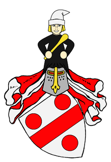
The coat of arms of the place shows a "silver on a blue Wellenschildfuß out below red dragon."
The place Reichenbach, always in close relationship with the in the 12th century Benedictine monastery was founded, had since your 15th century, the status of a market whose own administration led seals. A still preserved in the early 17th century copied temple shows a seal coat of arms, the founder of the monastery Reichenbach attributed heraldic figure, depicting the dragon. The image of this traditional emblem recalled the close relationship between city and monastery Reichenbach. To document the situation of the community on rain water was considered a symbol of so-called Wellenschildfuß elected, making a historic and equally motivated heraldic emblem community has been obtained.
Arts and Culture
This section is empty. You can help by adding to it. (July 2010)
Church life and customs
Numerous are the testimonies of former folk piety, in woods and fields to find. At some of them are still prayers and Masses celebrated, for example at the Marienplatz or at the so-called "Pfaffenstein."
On 9 June 1949 was the so-called "cross-host" on a hill above the town doomed, which residents of Reichenbach, thanks to build, that the village in war threats spared.[clarification needed] It bears the inscription "In this sign you will sing - for special thanks for protecting our village in danger of war" and was already established in 1946. Following the tradition there has been a cross 1914/1918 have confessed that during the period from 1939 to 1945 by fanatical groups was destroyed.
Since 1998, loads a crossroads, the Sonnhofweg along to this prayer site leads believers to linger in prayer. The Cross stations were in loving detail work of residents and employees of the monastery of the Brothers of Mercy artistically designed.
Marian devotion played in Reichenbach traditionally an important role. Persuade them, among other things Lourdesgrotte in the apse of the monastery church, which was inaugurated in 1895, and the mountain chapel in the street Pfister. The latter was built in 1935. The rock beside the chapel served the villagers during the Second World War as a protective bunker.
Since 1998, invites a chapel in Kienleiten the faithful to prayer. It was from the family Gerhard Reisinger after a promise is built and the St. Catherine doomed.
Not imagine from the church life were the Bittgänge, of community in which to weather and a good harvest was asked. On these occasions believers came from forest Erbach and Reichenbach to pray together. Reichenbach once attracted the forest after Erbach, another look at the forest after Erbacher Reichenbach, with them the faithful from praying Reichenbach went forward.
A highlight of the church year was certainly the Corpus Christi festival, in the vernacular "Prangertag referred. The path along which the procession went, it was with so-called "pillory Perennials" (birch), reed grass and fresh pine green with scarves and flags decorated. In addition, figurines and pictures of saints up to the house walls attached. Two statues of Our Lady, also per a figure of Joseph and Jesus were decorated with flowers and girls in the procession supported. For "Prangertag" belonged to it that the "landlord" or "Haering" to the traditional sausage meal went. Even if the sausages on the menu today are nothing more extraordinary, this usage has to this day.
Music
Reichenbach Church (since 1993) Reichenbacher monastery sparrows Employees choir of the monastery Reichenbach
Structures
Monastery of the Brothers of Mercy 1118 Founded former Benedictine abbey Romanesque monastery church (interior in the style of the Baroque and Rococo redesigned) Lourdesgrotte in the apse of the monastery church
Natural Monuments
Marienplatz (Marie picture and a wooden cross in the forest, space for prayer and worship) Pfaffenstein (highest point in the up area, located in the forest, a wooden cross in the rock, space for prayer and worship) Teufelsbuchs'n (Teufelsbuz'n) (steep cliffs with a short Schliefröhre in Kienleiten; under BUZ is a creature of stunted growth)
Sport
Recreation center of the DJK Reichenbach
Regular events
Easter market in the monastery Reichenbach Maifeier on youth campground Johannifeier on youth campground Dorfkirta in the beer garden (Patron's Feast) Christkindlmarkt (Christmas market) in the monastery Reichenbach
Economy and infrastructure
The Monastery of the Merciful Reichenbach brothers live more than 400 people with physical and mental disability and are about 500 employees. This makes it the most important employers in the region. Furthermore, in Reichenbach with a supermarket butcher, several master carpentry businesses, a master car, a vehicle body and paint shops, a plant for interior and Akustikbau, an advertising technology agency and other small businesses located. There are numerous small and large farms in Reichenbach.
Transport
The municipality parts Reichenbach and Kienleiten are reinforced by a bridge connected. Die Gemeinde Reichenbach liegt relativ nahe zu überörtlichen Verkehrsstraßen. Durch den Ort selbst verläuft die Kreisstraße CHA 25 (Hauptstraße) und die CHA 27 (Bodensteiner Straße). Die Ortsteile Reichenbach und Kienleiten sind durch die Staatsstraße St. 2149 getrennt. Der Verkehr in diesem Kreuzungsbereich wird durch eine Ampel geregelt. Die Auffahrt zur neu gebauten B 16 (Roding-Regensburg) ist nur 3,5km entfernt. Die Zufahrt zur B 85 (Schwandorf-Cham) ist ca. 15km entfernt.
Media
Chamer newspaper (circulation: 10,215 total)
The regional edition of the Straubinger Tagblattes / Landshuter Bayerwald Echo newspaper (circulation: 16,170 total)
Edition of the regional Bavarian newspaper Mitteilungsblatt
Education
Kindergarten St. Paul Reichenbach eingruppiger is a full-day kindergarten and is due mainly to the needs of working parents aligned. It consists of 1 October 1991. Looked after the children from the third year of life from the municipality and employees of the institution of the Brothers of Mercy Reichenbach. The municipality has no Reichenbach own school (more). Only a professional college education, curative care is available in Reichenbach. This is the monastery of the Brothers of Mercy building. The students from Reichenbach Erbach go to the forest in the primary and secondary school. The nearest school is located in Nittenau (Regentalgymnasium). The nearest school is the State School in Roding.
Personalities
Sons and daughters of the village
Andreas von Regensburg (born c. 1380 in Reichenbach on rain; died after 1442 in Regensburg)
Benefiziat Augustin Wagner (1898–1945), a priest in Ebrantshausen at Main castle (brother before Frida Wagner, vulg. "Wagnerfrida" colonial goods Kirchsteig)
People who have worked on the spot
All persons listed here are in very close contact with the monastery Reichenbach Markgrafentheater Diepold III. by Vohburg (born 10?; died 1146), monastery founder Pfalzgraf Otto I of Pfalz-Mosbach (1390–1461) Luth. Theologian, composer Johannes Hagius (1530–1596), 1556–1567 preacher and cantor in Reichenbach Anselm Meiller OSB, (born 15 February 1678 in Amberg, died 18 September 1761) Plank Domvikar Stetten George Dengler (1839–1896) Father Andrew Amrhein (born 4 February 1844 in Gunzwil, died 29 December 1927 in St. Ottilien) Frater Eustachius Kugler (born 15 January 1867 in Neuhaus in Nittenau; died 10 June 1946 in Regensburg) Kooperator Siegfried Hollmer (born 12 October 1930 in Konzell; died 19 April 1964), founder boys club Reichenbach (Burschenverein).
Related Research Articles
Regensburg is a city in eastern Bavaria, at the confluence of the Danube, Naab and Regen rivers. It is capital of the Upper Palatinate subregion of the state in the south of Germany. With more than 150,000 inhabitants, Regensburg is the fourth-largest city in the State of Bavaria after Munich, Nuremberg and Augsburg. From its foundation as an imperial Roman river fort, the city has been the political, economic and cultural center of the surrounding region. Later, under the rule of the Holy Roman Empire, it housed the Perpetual Diet of Regensburg.
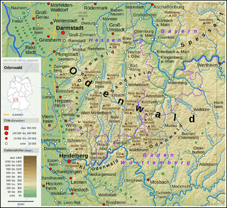
The Odenwald (help·info) is a low mountain range in the German states of Hesse, Bavaria and Baden-Württemberg.
The Bavarian Forest is a wooded, low-mountain region in Bavaria, Germany that is about 100 kilometres long. It runs along the Czech border and is continued on the Czech side by the Bohemian Forest. Most of the Bavarian Forest lies within the province of Lower Bavaria, but the northern part lies within Upper Palatinate. In the south it reaches the border with Upper Austria.
Jičín is a town in the Hradec Králové Region of the Czech Republic. It has about 17,000 inhabitants. It lies approximately 85 km northeast of Prague in the scenic region of the Bohemian Paradise under the Prachov Rocks.
The River Cole is a 25 miles (40 km) river in the English Midlands. It rises on the lower slopes of Forhill, one of the south-western ramparts of the Birmingham Plateau, at Red Hill and flows south before flowing largely north-east across the plateau to enter the River Blythe below Coleshill, near Ladywalk, shortly before the Blythe meets the Tame. This then joins the Trent, whose waters reach the North Sea via the Humber Estuary. Its source is very near the main watershed of Midland England : tributaries are few and very short except in the lower reaches, so the Cole is only a small stream.
Woronora is a suburb in southern Sydney, in the state of New South Wales, Australia. Woronora is located 27 kilometres south of the Sydney central business district, in the local government area of the Sutherland Shire. Woronora Heights is a separate suburb, to the south-west.
Reichenbach Monastery or Priory was a house of the Benedictine Order, located at Klosterreichenbach, now part of Baiersbronn in Baden-Württemberg in Germany.
Netphen is a town in the Siegen-Wittgenstein district, in North Rhine-Westphalia, Germany. It lies on the river Sieg, roughly 7 km northeast of Siegen.
Larrys Creek is a 22.9-mile-long (36.9 km) tributary of the West Branch Susquehanna River in Lycoming County in the U.S. state of Pennsylvania. A part of the Chesapeake Bay drainage basin, its watershed drains 89.1 square miles (231 km2) in six townships and a borough. The creek flows south from the dissected Allegheny Plateau to the Ridge-and-valley Appalachians through sandstone, limestone, and shale from the Devonian, Mississippian, and Pennsylvanian periods.
Hirschhorn (Neckar) is a small town in the Bergstraße district of Hesse, Germany, and is known as "The Pearl of the Neckar valley”. Hirschhorn is a climatic health resort situated in the Geo-Naturpark Bergstraße-Odenwald.
Beerfelden was a town in the Odenwald in the Odenwaldkreis (district) in Hesse, Germany, 28 km northeast of Heidelberg. On 1 January 2018 Beerfelden, Hesseneck, Rothenberg and Sensbachtal merged to create the town Oberzent.
The Los Angeles flood of 1938 was one of the largest floods in the history of Los Angeles, Orange, and Riverside Counties in southern California. The flood was caused by two Pacific storms that swept across the Los Angeles Basin in February-March 1938 and generated almost one year's worth of precipitation in just a few days. Between 113–115 people were killed by the flooding. The Los Angeles, San Gabriel, and Santa Ana Rivers burst their banks, inundating much of the coastal plain, the San Fernando and San Gabriel Valleys, and the Inland Empire. Flood control structures spared parts of Los Angeles County from destruction, while Orange and Riverside Counties experienced more damage.
Lindenholzhausen has been a district of the Town of Limburg an der Lahn, Hesse, Germany since 1972. The population on the 31st Jan. 2007 was 3,377. Lindenholzhausen has an average elevation of 170 metres above sea level and an area of 831.7 hectares (ha), making it the largest district of Limburg an der Lahn, the others being Ahlbach, Blumenrod, Dietkirchen, Eschhofen, Linter, Offheim and Staffel.
Kirchzell is a market community in the Miltenberg district in the Regierungsbezirk of Lower Franconia (Unterfranken) in Bavaria, Germany.
Tiefenbach is a municipality in the district of Passau in Bavaria in Germany.
Einöllen is an Ortsgemeinde – a municipality belonging to a Verbandsgemeinde, a type of collective municipality – in the Kusel district in Rhineland-Palatinate, Germany. It belongs to the Verbandsgemeinde Lauterecken-Wolfstein.
Oberweiler-Tiefenbach is an Ortsgemeinde – a municipality belonging to a Verbandsgemeinde, a kind of collective municipality – in the Kusel district in Rhineland-Palatinate, Germany. It belongs to the Verbandsgemeinde Lauterecken-Wolfstein.
Counts of Wartenberg were a German comital family (Grafen) which held large territories in Rhenish Hesse, Electoral Palatinate and Upper Swabia.
The gift register of an abbey or monastery was a record of the properties forming its estate, the majority of which came from gifts (Schenkungen). The register served as proof of the legitimacy of these properties and thus provided some security and protection for them. As a rule, the register comprised transcripts of the original documents, not the deed itself, as in the case of the sometimes protocular tradition books. In order to facilitate the management of the estate, documents spanning several centuries were often organised geographically. The entries were kept up-to-date over a longer period of time.
The Reichenbach Tower probably built in the 13th century and first mentioned in 1376 is the western part of the historic fortification of Görlitz. With a height of 51m it is the tallest of the three fortified towers in Görlitz..
Cornelia Oelwein (Edit): The traditions of the monastery at Reichenbach rain, Publisher: Beck (Munich), 1991 Werner Endres: Reichenbacher Steingut, Publisher: City Museum Association and Nittenau Nittenau, 1991 Josef Klose, Rudolf Knopp, Wolfgang Kauzner, Günter Lorenz: 875 years on the rain Klosterreichenbach 1118-1993, publisher: community Reichenbach, Johann-of-God-Verlag (Munich), 1993 Maria Kagerer et al.: 100plus: Reichenbacher Retrospective 1890-2000, publisher: community Reichenbach, 1999 Heribert Batzl: Klosterreichenbach on rain, Publisher: Fast and Steiner (Regensburg), 2001 Josef Klose; Arved from Ropp: The former Benedictine abbey church Reichenbach, Publisher: Fast and Steiner (Regensburg), 2002 Maria Kagerer, Hermann Reisinger, Norbert Mezei: 125 years volunteer firefighters Reichenbach: Festschrift for the founding celebration of 27 to 30 July 2007, editors: Volunteer Fire Reichenbach, 2007
This page is based on this Wikipedia article Text is available under the CC BY-SA 4.0 license; additional terms may apply. Images, videos and audio are available under their respective licenses.