Riacho Fundo

Last updated
Riacho Fundo
Região Administrativa de Riacho Fundo
Administrative Region of Riacho Fundo
Bandeira de Riacho Fundo (DF).svg
Distrito Federal RA RiachoFundo.svg
Location of Riacho Fundo in the Federal District
Brazil location map.svg
Red pog.svg
Riacho Fundo
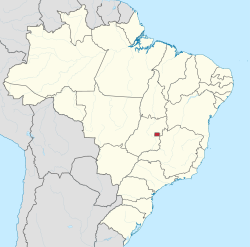
Location of Riacho Fundo in Brazil
Coordinates: 15°53′00″S48°01′03″W / 15.88333°S 48.01750°W / -15.88333; -48.01750
Country Brazil
Region Central-West
State Federal District
FoundedMarch 13, 1990
Government
   Regional administrator Heitor Mitsuaki Kanegae [1]
Area
  Total56.02 km2 (21.63 sq mi)
Population
 (2013) [2]
  Total37,278
  Density670/km2 (1,700/sq mi)
Time zone UTC−3 (BRT)
Postal Code (CEP)
71800-000
Area code +55 61
Website www.riachofundo.df.gov.br

Riacho Fundo is an administrative region in the Federal District in Brazil. Riacho Fundo was founded on March 13, 1990, receiving the status of administrative region, according to Law 620, of December 15, 1993.

Contents

See also

Related Research Articles

<span class="mw-page-title-main">Federal District (Brazil)</span> Federative units of Brazil

The Federal District is one of 27 federative units of Brazil. Located in the Center-West Region, it is the smallest Brazilian federal unit and the only one that has no municipalities, being divided into 33 administrative regions. The federal capital of Brazil, Brasília, which is also the seat of government of the Federal District, is located in its territory. The Federal District is almost completely surrounded by the state of Goiás, but it shares a small border with Minas Gerais.

<span class="mw-page-title-main">Sobradinho, Federal District</span> Administrative region in Central-West, Brazil

Sobradinho is an administrative region in the Federal District in Brazil. It is bordered by Fercal to the north, Planaltina to the east, Itapoã to the south, and Lago Norte and Sobradinho II to the west.

<span class="mw-page-title-main">Beberibe</span> Municipality in Northeast, Brazil

Beberibe is a municipality in the state of Ceará in Brazil. Its estimated population in 2020 is 53,949.

<span class="mw-page-title-main">Subdivisions of Brazil</span>

Brazil is divided into several types and levels of subdivisions.

<span class="mw-page-title-main">Gama, Federal District</span> Administrative region in Central-West, Brazil

Gama is an administrative region in the Federal District in Brazil. It is bordered by Recanto das Emas to the north, Riacho Fundo II and Park Way to the northeast, and Santa Maria to the east.

<span class="mw-page-title-main">Taguatinga, Federal District</span> Administrative region in Central-West, Brazil

Taguatinga is an administrative region in the Federal District in Brazil. It is bordered by Brasília to the north, Vicente Pires, Águas Claras, and Arniqueira to the east, Riacho Fundo and Riacho Fundo II to the south, Samambaia to the southwest, Ceilândia to the west, and Brazlândia to the northwest.

<span class="mw-page-title-main">Administrative regions of the Federal District (Brazil)</span> Overview of administrative divisions of Federal District, Brazil

The administrative regions of the Federal District are administrative divisions of the Federal District, Brazil.

<span class="mw-page-title-main">Águas Claras, Federal District</span> Administrative region in Central-West, Brazil

Águas Claras is an administrative region in the Federal District in Brazil. It is bordered by Vicente Pires to the north, Guará and Park Way to the east, Arniqueira to the south, and Taguatinga to the west.

<span class="mw-page-title-main">Núcleo Bandeirante</span> Administrative region in Central-West, Brazil

Núcleo Bandeirante is an administrative region in the Federal District in Brazil. It is located to the west of Paranoá Lake, being bordered by Arniqueira, Park Way, and Guará to the north, Candangolândia to the east, and Park Way and Riacho Fundo to the south. Núcleo Bandeirante was founded on December 19, 1956, receiving the status of administrative region, according to Law 4545, of December 10, 1964.

<span class="mw-page-title-main">Recanto das Emas</span> Administrative region in Central-West, Brazil

Recanto das Emas is an administrative region in the Federal District in Brazil. It is located to the westmost area of the Federal District, being bordered by Samambaia to the north, Riacho Fundo II to the east, Gama to the south, and the border to Goiás to the west. Recanto das Emas was founded on July 28, 1993, receiving the status of administrative region, according to Law 510, of July 28, 1993.

<span class="mw-page-title-main">Federal Institute of Brasília</span>

The Federal Institute of Brasília, or in full: Federal Institute of Education, Science and Technology of Brasília is an Institute of Technology located at the capital of Brazil that offers different types of degrees and operating often at variable levels of the educational system. It is an institution of Higher education and professional vocational education, specializing in science, engineering, and technology or different sorts of technical subjects. It is also a secondary education school focused on vocational training and applied Scientific research.

<span class="mw-page-title-main">Cruzeiro, Federal District</span> Administrative region in Central-West, Brazil

Cruzeiro is an administrative region in the Federal District in Brazil. It is bordered by SIA and Brasília to the north, and Sudoeste/Octogonal to the southeast. Created in 1959, Cruzeiro is divided into two broad sections: the original town, Cruzeiro Velho, made up mostly of one- and two-story houses, and Cruzeiro Novo, made up of several similar four-story buildings since 1970. Cruzeiro has a total area of 319,3 hectares.

<span class="mw-page-title-main">Guará, Federal District</span> Administrative region in Central-West, Brazil

Guará is an administrative region in the Federal District in Brazil. It is bordered by SIA to the north, Sudoeste/Octogonal and Candangolândia to the west, Núcleo Bandeirante to the south, Park Way to the southeast, and Águas Claras to the east, and Vicente Pires to the northeast. Guará was founded on May 5, 1969, receiving the status of administrative region, according to Law 49, of October 25, 1989.

<span class="mw-page-title-main">Samambaia, Federal District</span> Administrative region in Central-West, Brazil

Samambaia is an administrative region in the Federal District in Brazil. It is bordered by Ceilândia and Sol Nascente/Pôr do Sol to the north, Taguatinga to the east, and Riacho Fundo II and Recanto das Emas to the south. Samambaia was founded on October 25, 1989, receiving the status of administrative region, according to Law 49, of October 25, 1989. Its current administrator is Marcos Leite de Araújo.

<span class="mw-page-title-main">Park Way</span> Administrative region in Central-West, Brazil

Park Way is an administrative region in the Federal District in Brazil. It is located southwest of Paranoá Lake. Consisting of two separated portions, it is bordered clockwise by Águas Claras, Guará, Núcleo Bandeirante, and Arniqueira in its northern half; and Núcleo Bandeirante, Candangolândia, Lago Sul, Jardim Botânico, Santa Maria, Gama, Riacho Fundo and Riacho Fundo II in its southern half. Park Way was founded on March 13, 1961, receiving the status of administrative region, according to Law 3255, of December 29, 2003.

<span class="mw-page-title-main">São Geraldo do Araguaia Environmental Protection Area</span> Protected area in Pará, Brazil

The São Geraldo do Araguaia Environmental Protection Area is an environmental protection area in the state of Pará, Brazil. The original vegetation was dense rainforest, but it is now mostly used for cattle ranching. Visitor attractions include waterfalls and prehistoric rock carvings.

<span class="mw-page-title-main">Setor de Indústria e Abastecimento</span> Administrative region in Central-West, Brazil

Setor de Indústria e Abastecimento is an administrative region in the Federal District in Brazil. It is bordered by Brasília to the north and northeast, Cruzeiro and Sudoeste/Octogonal to the east, Guará and Vicente Pires to the south, and SCIA to the west. Setor de Indústria e Abastecimento is, alongside SCIA, an industrial hub in the Federal District, being host to various industries such as construction, logistics, and commerce. Setor de Indústria e Abastecimento was founded on April 21, 1969, receiving the status of administrative region, according to Law 3618, of July 14, 2005.

<span class="mw-page-title-main">Riacho Fundo II</span> Administrative region in Central-West, Brazil

Riacho Fundo II is an administrative region in the Federal District in Brazil. Riacho Fundo II was founded on May 6, 1995, receiving the status of administrative region, according to Law 3153, of May 6, 2003.

<span class="mw-page-title-main">Arniqueira</span> Administrative region in Central-West, Brazil

Arniqueira is an administrative region in the Federal District in Brazil. Arniqueira grew substantially between 2000 and 2010, in which the population went from 18,716 to 43,718. In 2015 it was projected that the administrative region would have 46,621 inhabitants in 2020, and in 2021 the region reached 47,045.

References

  1. "Perfil do administrador – Administração Regional de Riacho Fundo". Archived from the original on 2017-07-08. Retrieved 2017-07-07.
  2. "Pesquisa Distrital por Amostra de Domicílios - 2010/2011" (PDF) (in Portuguese). Codeplan . Retrieved 2013-04-09.