Santa Maria, Federal District

Last updated
Santa Maria
Região Administrativa de Santa Maria
Administrative Region of Santa Maria
Bandeira de Santa Maria (DF).jpg
Distrito Federal RA SantaMaria.svg
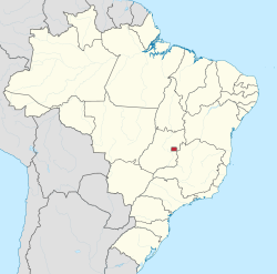
Location of Santa Maria in the Federal District
Coordinates: 16°00′55″S48°00′47″W / 16.01528°S 48.01306°W / -16.01528; -48.01306
Country Flag of Brazil.svg  Brazil
Region Central-West
State Bandeira do Distrito Federal (Brasil).svg Federal District
Established10 February 1991
Government
   Regional administrator Marileide Romão
Area
  Total215.86 km2 (83.34 sq mi)
Population
  Total115,607
  Density540/km2 (1,400/sq mi)
Time zone UTC-3 (UTC-3)
  Summer (DST) UTC-2 (UTC-2)
Area code +55 61
Website www.santamaria.df.gov.br

Santa Maria is an administrative region in the Federal District in Brazil. Santa Maria was founded on February 10, 1991, receiving the status of administrative region, according to Law 348, of November 4, 1992.

Contents

Notable people

See also

Related Research Articles

<span class="mw-page-title-main">Santa Barbara County, California</span> County in California, United States

Santa Barbara County, officially the County of Santa Barbara, is located in Southern California. As of the 2020 census, the population was 448,229. The county seat is Santa Barbara, and the largest city is Santa Maria.

<span class="mw-page-title-main">Santa Maria, California</span> City in California, United States

Santa Maria is a city in the Central Coast of California in northern Santa Barbara County. It is approximately 65 miles (105 km) northwest of Santa Barbara and 150 miles (240 km) northwest of downtown Los Angeles. Its population was 109,707 at the 2020 census, making it the most populous city in the county and the Santa Maria-Santa Barbara, CA Metro Area. The city is notable for its wine industry and Santa Maria-style barbecue.

<span class="mw-page-title-main">Tula Oblast</span> First-level administrative division of Russia

Tula Oblast is a federal subject of Russia. It is geographically located in European Russia and is administratively part of the Central Federal District, covering an area of 25,700 square kilometers (9,900 sq mi). It has a population of 1,553,925 (2010 Census). Tula is the largest city and the administrative center of the oblast.

<span class="mw-page-title-main">Santa Maria da Feira</span> Municipality in Norte, Portugal

Santa Maria da Feira is a city and a municipality in Aveiro District in Portugal, 23 km from central Porto. The population in 2011 was 139,309, in an area of 215.88 km².

<span class="mw-page-title-main">Taganrog</span> City in Rostov Oblast, Russia

Taganrog is a port city in Rostov Oblast, Russia, on the north shore of Taganrog Bay in the Sea of Azov, several kilometers west of the mouth of the Don River. It is in the Black Sea region. Population: 245,120 (2021 Census); 257,681 (2010 Census); 281,947 (2002 Census); 291,622 (1989 Census).

<span class="mw-page-title-main">Santa Maria, Rio Grande do Sul</span> Municipality in the state of Rio Grande do Sul, Brazil

Santa Maria is a municipality (município) in the central region of Rio Grande do Sul, the southernmost state of Brazil. In 2020, its population was 283,677 inhabitants in a total area of 1,823 square kilometres (704 sq mi). Santa Maria is the 5th biggest municipality in the state, and the largest in its micro-region.

<span class="mw-page-title-main">Lima District</span> District in Lima, Peru

Lima is a district of Lima Province in Peru. Lima district is the oldest in Lima Province and as such, vestiges of the city's colonial era remain today in the historic centre of Lima, which was declared a UNESCO World Heritage Site in 1988 and contains the foundational area known as Cercado de Lima.

<span class="mw-page-title-main">Santa Maria, Bulacan</span> Municipality in Bulacan, Philippines

Santa Maria, officially the Municipality of Santa Maria, is a 1st class urban municipality in the province of Bulacan, Philippines. According to the 2020 census, it has a population of 289,820 people. representing 7.8% of the population of the province.

<span class="mw-page-title-main">Ceilândia</span> Administrative region in Central-West, Brazil

Ceilândia is an administrative region in the Federal District in Brazil. It is bordered by Brazlândia to the north, Taguatinga to the east, and Samambaia and Sol Nascente/Por do Sol to the south. With about 398,374 inhabitants, it is the administrative region of largest population in the Federal District. Ceilândia was created on 1971 by Hélio Prates da Silveira, originally created as the "CEI" in 1969, a campaign to combat irregular settlements near Brasília.

Santa María Jalapa del Marqués is a small city in the Mexican state of Oaxaca. It serves as the administrative centre for the surrounding municipality (municipio) of the same name. It is part of the Tehuantepec District in the west of the Istmo Region.

<span class="mw-page-title-main">Lurigancho-Chosica</span> District in Lima, Peru

Lurigancho-Chosica is a district of Lima Province, Peru, located in the valley of the Rímac River, which it shares with neighboring Chaclacayo and Ate districts. Its capital is the town of Chosica. Its administrative center is located 861 m (2,825 ft) above sea level.

The Philippines is divided into four levels of administrative divisions, with the lower three being defined in the Local Government Code of 1991 as local government units (LGUs). They are, from the highest to the lowest:

  1. Regions are mostly used to organize national services. Of the 17 regions, only one—the Bangsamoro Autonomous Region in Muslim Mindanao—has an elected government to which the central government has devolved competencies.
  2. Provinces, independent cities, and one independent municipality (Pateros)
  3. Component cities and municipalities within a province
  4. Barangays within a city or municipality
<span class="mw-page-title-main">Santa Maria in Calanca</span> Municipality in Graubünden, Switzerland

Santa Maria in Calanca is a municipality in the Moesa Region in the Swiss canton of Graubünden.

<span class="mw-page-title-main">Legislative districts of Ilocos Sur</span>

The legislative districts of Ilocos Sur are the representations of the province of Ilocos Sur in the various national legislatures of the Philippines. The province is currently represented in the lower house of the Congress of the Philippines through its first and second congressional districts.

<span class="mw-page-title-main">Subdivisions of Brazil</span>

Brazil is divided into several types and levels of subdivisions.

<span class="mw-page-title-main">Gama, Federal District</span> Administrative region in Central-West, Brazil

Gama is an administrative region in the Federal District in Brazil. It is bordered by Recanto das Emas to the north, Riacho Fundo II and Park Way to the northeast, and Santa Maria to the east.

<span class="mw-page-title-main">Taguatinga, Federal District</span> Administrative region in Central-West, Brazil

Taguatinga is an administrative region in the Federal District in Brazil. It is bordered by Brasília to the north, Vicente Pires, Águas Claras, and Arniqueira to the east, Riacho Fundo and Riacho Fundo II to the south, Samambaia to the southwest, Ceilândia to the west, and Brazlândia to the northwest.

<span class="mw-page-title-main">Central Zone of São Paulo</span> Place in São Paulo, Brazil

The Central Zone is an administrative zone of the city of São Paulo, Brazil.

<span class="mw-page-title-main">Park Way</span> Administrative region in Central-West, Brazil

Park Way is an administrative region in the Federal District in Brazil. It is located southwest of Paranoá Lake. Consisting of two separated portions, it is bordered clockwise by Águas Claras, Guará, Núcleo Bandeirante, and Arniqueira in its northern half; and Núcleo Bandeirante, Candangolândia, Lago Sul, Jardim Botânico, Santa Maria, Gama, Riacho Fundo and Riacho Fundo II in its southern half. Park Way was founded on March 13, 1961, receiving the status of administrative region, according to Law 3255, of December 29, 2003.

References