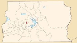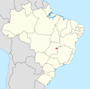
Brasília is the federal capital of Brazil and seat of government of the Federal District, located in the Brazilian highlands in the country's Central-West region. It was founded by President Juscelino Kubitschek on 21 April 1960, to replace Rio de Janeiro as the national capital. Brasília is Brazil's third-most populous city after São Paulo and Rio de Janeiro. Among major Latin American cities, it has the highest GDP per capita.

The Federal District is one of 27 federative units of Brazil. Located in the Center-West Region, it is the smallest Brazilian federal unit and the only one that has no municipalities, being divided into 35 administrative regions. The federal capital of Brazil, Brasília, which is also the seat of government of the Federal District, is located in its territory. The Federal District is almost completely surrounded by the state of Goiás, but it shares a small border with Minas Gerais.
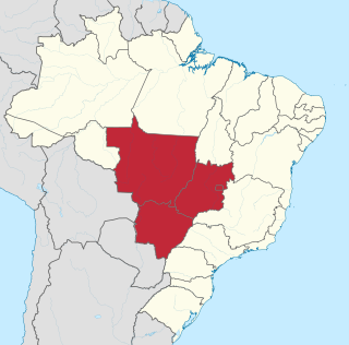
The Central-West or Center-West Region of Brazil is composed of the states of Goiás, Mato Grosso and Mato Grosso do Sul; along with Distrito Federal, where Brazil's national capital, Brasília, is situated. The region comprises 18.86% of the national territory, and is the least populated in Brazil.

Ceilândia is an administrative region in the Federal District in Brazil. It is bordered by Brazlândia to the north, Taguatinga to the east, and Samambaia and Sol Nascente/Por do Sol to the south. With about 398,374 inhabitants, it is the administrative region of largest population in the Federal District. Ceilândia was created in 1971 by Hélio Prates da Silveira, originally created as the "CEI" in 1969, a campaign to combat irregular settlements near Brasília.

The Federal District Metro is the rapid transit system of the Federal District, in Brazil. It is operated by Companhia do Metropolitano do Distrito Federal and was opened in 2001. Currently, Federal District's Metro has 27 stations on two lines, and it runs for 42.38 kilometers (26.33 mi). The system passes through 6 Administrative regions of the Federal District, those being Brasília, Guará, Águas Claras, Taguatinga, Ceilândia, and Samambaia.

Planaltina is an administrative region in the Federal District in Brazil. It is located in the east of the Federal District, bordering Fercal, Sobradinho, and Itapoã to the west, and Paranoá to the south. With an area of 1.534 square kilometers, it is the largest administrative region of the Federal District. Planaltina has a population of 177.540. The region seat was founded in 1859 and is the oldest city in the Federal District.
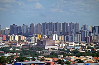
Taguatinga is an administrative region in the Federal District in Brazil. It is bordered by Brasília to the north, Vicente Pires, Águas Claras, and Arniqueira to the east, Riacho Fundo and Riacho Fundo II to the south, Samambaia to the southwest, Ceilândia to the west, and Brazlândia to the northwest. Taguatinga has a population of 222,598, being the fourth largest administrative region by population.
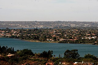
Lago Norte is an administrative region in the Federal District in Brazil. Located to the north side of Paranoá Lake, it is bordered by Brasília, Sobradinho II, and Sobradinho to the north, Itapoã and Paranoá to the east. Lago Norte shares a maritime border with Lago Sul, Paranoá, and Brasília through the Paranoá Lake. It completely surrounds the administrative region of Varjão. Most of its inhabited area is located on a peninsula of Lake Paranoá. Lago Norte is home to the Brasília Digital TV Tower. Lago Norte was founded on January 10, 1960, receiving the status of administrative region, according to Law 641, of January 10, 1994. In a 2010 report, its population was 41,627. Its current administrator is Marcelo Ferreira da Silva.

Águas Claras is an administrative region in the Federal District in Brazil. It is bordered by Vicente Pires to the north, Guará and Park Way to the east, Arniqueira to the south, and Taguatinga to the west.

Brazlândia is the second oldest administrative region in the Federal District in Brazil. It is bordered by Sobradinho II to the northeast, Brasília to the east, and Taguatinga and Ceilândia to the south. Brazlândia was founded on June 5, 1933, receiving the status of administrative region, according to Law 4545, of December 10, 1964. Its current administrator is Devanir Gonçalves de Oliveira. It has a population of approximately 55,000 people.

The IBGE Ecological Reserve, is a protected area in the Federal District, Brazil. It has a diverse ecology including various rare or endangered species, and is an important center for research into the ecology of the poorly protected Cerrado environment. Numerous scientific papers have referred to research conducted in the reserve.

Guará is an administrative region in the Federal District in Brazil. It is bordered by SIA to the north, Sudoeste/Octogonal and Candangolândia to the west, Núcleo Bandeirante to the south, Park Way to the southeast, and Águas Claras to the east, and Vicente Pires to the northeast. Guará was founded on May 5, 1969, receiving the status of administrative region, according to Law 49, of October 25, 1989.

Samambaia is an administrative region in the Federal District in Brazil. It is bordered by Ceilândia and Sol Nascente/Pôr do Sol to the north, Taguatinga to the east, and Riacho Fundo II and Recanto das Emas to the south. With a population of 232,893, it is the second largest administrative region by population, behind Ceilândia. Samambaia was founded on October 25, 1989, receiving the status of administrative region, according to Law 49, of October 25, 1989. Its current administrator is Marcos Leite de Araújo.

Vicente Pires is an administrative region in the Federal District in Brazil. It is bordered by Taguatinga to the west, Águas Claras to the south, Guará to the southeast, Brasília to the north, and Brazlândia to the northwest. According to a 2016 report, Vicente Pires has a population of 72,879. Vicente Pires is the 16th largest administrative region by population.

Setor Complementar de Indústria e Abastecimento is an administrative region in the Federal District in Brazil. It is bordered by Brasília to the north, SIA to the east and south, and Vicente Pires to the west. Setor Complementar de Indústria e Abastecimento was founded on October 25, 1989, receiving the status of administrative region, according to Law 3315, of January 27, 2004. Its current administrator is Alceu Prestes de Mattos. As of 2010, it has a population of 25,732.

Setor de Indústria e Abastecimento is an administrative region in the Federal District in Brazil. It is bordered by Brasília to the north and northeast, Cruzeiro and Sudoeste/Octogonal to the east, Guará and Vicente Pires to the south, and SCIA to the west. Setor de Indústria e Abastecimento is, alongside SCIA, an industrial hub in the Federal District, being host to various industries such as construction, logistics, and commerce. Setor de Indústria e Abastecimento was founded on April 21, 1969, receiving the status of administrative region, according to Law 3618, of July 14, 2005.

Sudoeste/Octogonal is an administrative region in the Federal District in Brazil. It is largely surrounded by Brasília to the east, and bordered by SIA and Cruzeiro to the west. Sudoeste/Octogonal was founded on July 10, 1989, receiving the status of administrative region, according to Law 3153, of May 6, 2003.

Miss Distrito Federal, formerly called Miss Brasília, is a Brazilian Beauty pageant which selects the representative for the Brazilian Federal District at the Miss Brazil contest. The pageant was created in 1959 and has been held every year since with the exception of 1990–1991, 1993, and 2020. The pageant is held annually with representation of several municipalities. Since 2019, the State director of Miss Distrito Federal is, Mayck Carvalho.
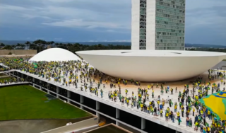
On 8 January 2023, following the defeat of then-president Jair Bolsonaro in the 2022 Brazilian general election and the inauguration of his successor Luiz Inácio Lula da Silva, a mob of Bolsonaro's supporters attacked Brazil's federal government buildings in the capital, Brasília. The mob invaded and caused deliberate damage to the Supreme Federal Court, the National Congress Palace and the Planalto Presidential Palace in the Praça dos Três Poderes, seeking to violently overthrow the democratically elected president Lula, who had been inaugurated on 1 January. Many rioters said their purpose was to spur military leaders to launch a "military intervention" and disrupt the democratic transition of power.

Arniqueira is an administrative region in the Federal District in Brazil. Arniqueira grew substantially between 2000 and 2010, in which the population went from 18,716 to 43,718. In 2015 it was projected that the administrative region would have 46,621 inhabitants in 2020, and in 2021 the region reached 47,045.
