Ringstead, Northamptonshire

Last updated

Ringstead
New Inn, Ringstead (geograph 2546340).jpg
New Inn
Northamptonshire UK location map (2021).svg
Red pog.svg
Ringstead
Location within Northamptonshire
Population1,461  (2011 census)
OS grid reference SP9875
Unitary authority
Ceremonial county
Region
Country England
Sovereign state United Kingdom
Post town Kettering
Postcode district NN14
Dialling code 01933
Police Northamptonshire
Fire Northamptonshire
Ambulance East Midlands
UK Parliament
List of places
UK
England
Northamptonshire
52°22′07″N0°33′17″W / 52.3687°N 0.5547°W / 52.3687; -0.5547

Ringstead is a village and civil parish in Northamptonshire, England, forming part of North Northamptonshire. It is located approximately 15 miles north-east of Northampton. At the time of the 2011 census, the parish's population was 1,461 people. [1] The local primary school is situated next to St Mary's Church, which is host to the Ringstead Flower Festival.

Contents

History

The village's name means 'Ring place'. The meaning of the name here is obscure. [2]

Ringstead was the birthplace of:

According to tradition, the entrance to St Mary's churchyard has been haunted by the ghost of a village girl, Lydia Atley, who disappeared in 1850. What were thought to be her skeletal remains were unearthed in 1864 in a local orchard; the village butcher, Weekly Ball, was tried for Lydia's murder but acquitted because it proved impossible to conclusively identify the skeleton as that of the missing girl. [3]

During the 1980s, major sand and gravel excavations took place all around Ringstead leaving many man-made lakes and islands.

In 2007, Ringstead, Hargrave, Raunds and Stanwick were legally united as "The 4 Spires Benefice", with each village retaining its own church. [4]

Heritage assets

The following buildings and structures are listed by Historic England as of special architectural or historic interest. [5]

Demography

Sport

Football

The village has a relatively successful sporting tradition in football. They have had a team representing the village for over 100 years since it was established in 1896. Ringstead Rangers includes a men's team, a men's reserve team, an under 17s, under 14s and an under 9s team. All the teams play their home matches at Ringstead Recreational Ground and their traditional strip colours consist of red and black. The teams have been known to sport various other strip colours, especially in their away strips, including orange, blue and pink.

Social club

Activities at the Village Social Club include pool; the team currently plays in Division 3 of the East Northamptonshire League. It also has a skittles team and facilities for darts, bingo and dominoes.

The River Nene runs past the village in a series of locks. A National Lottery funded cycle, bridle and footpath track runs between Stanwick Lakes and Islip, the Nene Way running through the area all offering easy walking. Ringstead has a very large boating community and features over 250 river craft moored at Willy Watt Marina and Blackthorn Lake Marina.

Nature reserve

Kinewell Lake is a local nature reserve and part of the Upper Nene Valley Gravel Pits Site of Special Scientific Interest, Ramsar wetland site of international importance and Special Protection Area under the European Communities Birds Directive.

Related Research Articles

<span class="mw-page-title-main">Raunds</span> Human settlement in England

Raunds is a market town in North Northamptonshire, England. It had a population of 9,379 at the 2021 census.

<span class="mw-page-title-main">East Northamptonshire</span> Former non-metropolitan district in England

East Northamptonshire was a local government district in Northamptonshire, England, from 1974 to 2021. Its council was based in Thrapston and Rushden. Other towns included Oundle, Raunds, Irthlingborough and Higham Ferrers. The town of Rushden was by far the largest settlement in the district. The population of the district at the 2011 Census was 86,765.

<span class="mw-page-title-main">Farthingstone</span> Village in Northamptonshire, England

Farthingstone is a village in West Northamptonshire in England. It is close to the major trunk routes of the M1 junction 16, M40 motorway, and A5 road, at the head of a valley and is 7 miles (11 km) south of Daventry and 3.5 miles (5.6 km) south west of Weedon Bec.

Hargrave is a small village and civil parish situated in rural Northamptonshire, England, approximately 21 miles east of Northampton and adjacent to the Northamptonshire-Cambridgeshire-Bedfordshire border. At the time of the 2001 census, the parish's population was 236 people,. increasing to 241 at the 2011 census.

<span class="mw-page-title-main">Woodford, Northamptonshire</span> Human settlement in England

Woodford is a large village and civil parish located in North Northamptonshire, England. At the time of the 2011 census, the parish's population was 1,461 people.

<span class="mw-page-title-main">Corby and East Northamptonshire (UK Parliament constituency)</span> Parliamentary constituency in the United Kingdom, 1983 onwards

Corby and East Northamptonshire is a constituency in the English county of Northamptonshire. It is represented in the House of Commons of the UK Parliament since July 2024 by Lee Barron, of the Labour Party.

Stanwick is a village and civil parish in North Northamptonshire, England.

<span class="mw-page-title-main">Great Addington</span> Human settlement in England

Great Addington is a small village and civil parish in Northamptonshire, England. It lies near the west bank of the River Nene, about 5 miles (8 km) east of Kettering. It consists of approximately 100 households; at the time of the 2011 census, the population of the parish was 327 people. It has a school, church, manor house, village hall, a pub called the Hare & Hounds, playing fields and homes. There is a strong bond and rivalry with the neighbouring village Little Addington.

Thrapston was a rural district in England from 1894 to 1935. It was one of the only rural districts to be split between administrative counties, with part in Northamptonshire and part in Huntingdonshire.

<span class="mw-page-title-main">Chelveston</span> Human settlement in England

Chelveston is a small village in North Northamptonshire. It is about 2 miles (3.2 km) east of Higham Ferrers and 7 miles (11.3 km) east of Wellingborough on the B645 from Higham Ferrers to St Neots. To the south is the hamlet of Caldecott and the settlement of Chelston Rise which together comprise the civil parish of Chelveston cum Caldecott. The population is now included in the civil parish of Chelveston cum Caldecott.

<span class="mw-page-title-main">Middleton Cheney</span> Human settlement in England

Middleton Cheney is a large village and civil parish in West Northamptonshire, England. The village is about 3 miles (5 km) east of Banbury in Oxfordshire and about 6 miles (10 km) west-northwest of Brackley. The A422 road between Banbury and Brackley used to pass through Middleton Cheney, but now bypasses it to the south.

<span class="mw-page-title-main">A605 road</span> Main road in the English counties of Northamptonshire and Cambridgeshire

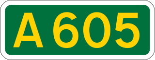
The A605 road is a main road in the English counties of Northamptonshire and Cambridgeshire.

<span class="mw-page-title-main">Denford</span> Human settlement in England

Denford is a small village and civil parish situated in North Northamptonshire, England. At the time of the 2001 census, the parish population was 250 people, increasing to 282 at the 2011 census.

<span class="mw-page-title-main">Little Addington</span> Human settlement in England

Little Addington is a village and civil parish in North Northamptonshire, England, about 8 miles (13 km) south-east of Kettering. At the time of the 2011 census, the parish's population was 328 people. Prior to local government restructuring in 2021 the village was in the area of East Northamptonshire District Council.

<span class="mw-page-title-main">St Peter's Church, Raunds</span> Church

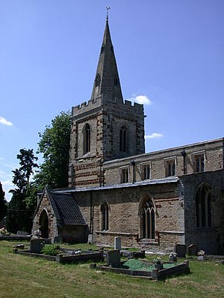
St Peter's Church is an Anglican Church and the parish church of Raunds. It is a Grade I listed building and stands in an elevated position in Church Street.

<span class="mw-page-title-main">Church of St Laurence, Stanwick</span>

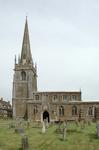
The Church of St Laurence is a Grade I listed building in the village of Stanwick in North Northamptonshire. It was originally within the Church of England Diocese of Lincoln but was transferred to the Diocese of Peterborough in 1541 towards the end of the Dissolution of the Monasteries during Henry VIII's reign.

<span class="mw-page-title-main">Stanwick Lakes</span> Human settlement in England

Stanwick Lakes is a country park on the outskirts of the village of Stanwick and was opened in 2006. It is managed by the Rockingham Forest Trust on behalf of East Northamptonshire District Council and comprises 750 acres of former gravel pits. It is part of the larger River Nene Regional Park.

<span class="mw-page-title-main">Ditchford Lakes and Meadows</span> Nature reserve in the United Kingdom

Ditchford Lakes and Meadows is a 31.1-hectare (77-acre) nature reserve Northamptonshire. It is managed by the Wildlife Trust for Bedfordshire, Cambridgeshire and Northamptonshire. It is part of the Upper Nene Valley Gravel Pits Site of Special Scientific Interest, Ramsar wetland site of international importance, and Special Protection Area under the European Communities Birds Directive.

<span class="mw-page-title-main">War Memorial, Stanwick</span>

The War Memorial is a Grade II listed structure located in the churchyard of the Church of St Laurence in the village of Stanwick.

<span class="mw-page-title-main">Kinewell Lake</span>

Kinewell Lake is a 35.4 hectare Local Nature Reserve west of Ringstead in Northamptonshire, England. It is owned by Ringstead Parish Council and managed by Kinewell Lake Trust. The site is part of the Upper Nene Valley Gravel Pits Site of Special Scientific Interest, Ramsar wetland site of international importance, and Special Protection Area under the European Communities Birds Directive.

References

  1. Office for National Statistics: Ringstead CP: Parish headcounts. Retrieved 15 July 2015
  2. "Key to English Place-names".
  3. Codd, Daniel. Mysterious Northamptonshire (2009). Breedon Books Publishing Company. p.28. ISBN   9781859836811.
  4. "4 Spires Benefice" . Retrieved 11 September 2015.
  5. The National Heritage List for England (Historic England)
  6. 1 2 3 William Whellan & Co. (1849). History, Gazetteer and Directory Northamptonshire. Whittaker & Co. p. 881.
  7. Office for National Statistics, Census 2011