
Catron County is a county in the U.S. state of New Mexico. As of the 2010 census, the population was 3,725, making it New Mexico's third-least populous county. Its county seat is Reserve. Catron County is New Mexico's largest county by area.

The name Jornada del Muerto is translated loosely from Spanish, historically referring to it as the "Journey of the Dead Man", though the modern literal translation is closer to "The Working Day of the Dead". As a geographic name, "Jornada del Muerto" is the desert region the Conquistadors had to cross to make it from Las Cruces to Socorro, New Mexico. As a name-place, "Jornada del Muerto" is a loose translations of "single day's journey of the dead man" hence "route of the dead man") in the U.S. state of New Mexico was the name given by the Spanish conquistadors to the Jornada del Muerto Desert basin, and the particularly dry 100-mile (160 km) stretch of a route through it.

The Salt River is a stream in the U.S. state of Arizona. It is the largest tributary of the Gila River. The river is about 200 miles (320 km) long. Its drainage basin is about 13,700 square miles (35,000 km2) large. The longest of the Salt River's many tributaries is the 195-mile (314 km) Verde River. The Salt's headwaters tributaries, the Black River and East Fork, increase the river's total length to about 300 miles (480 km). The name Salt River comes from the fact that the river flows over large salt deposits shortly after the merging of the White and Black Rivers.

The Conejos River is a tributary of the Rio Grande, approximately 92.5 miles (148.9 km) long, in south-central Colorado in the United States. It drains a scenic area of the eastern San Juan Mountains west of the San Luis Valley.

An arroyo, also called a wash, is a dry creek, stream bed or gulch that temporarily or seasonally fills and flows after sufficient rain. Flash floods are common in arroyos following thunderstorms.
The Galisteo Basin is a surface basin and a closely related groundwater basin in north-central New Mexico. Its primary watercourse is the Galisteo River or Galisteo Creek, a perennial stream, for part of its course, that flows from the eastern highlands down into the Rio Grande about three miles above the Santo Domingo Pueblo. The Galisteo basin covers approximately 467,200 acres and runs from San Miguel County in the east, across Santa Fe County, and into Sandoval County at its westernmost point, the Rio Grande. Northeast of Galisteo Basin rise the Sangre de Cristo Mountains and to the southwest lie the Sandia Mountains. Because of its location lying between mountain ranges and connecting the Rio Grande Valley with the Great Plains, the Galisteo Basin was used as a trade route by prehistoric and historic indigenous and later also by the Spanish explorers.

The Rio Chama, a major tributary river of the Rio Grande, is located in the U.S. states of Colorado and New Mexico. The river is about 130 miles (210 km) long altogether. From its source to El Vado Dam its length is about 50 miles (80 km), from El Vado Dam to Abiquiu Dam is about 51 miles (82 km), and from Abiquiu Dam to its confluence with the Rio Grande is about 34 miles (55 km).

The Rio Grande Trail is a proposed long distance trail along the Rio Grande in the U.S. state of New Mexico. The river extends over 1,800 total miles, some 700 miles (1,100 km) of which pass through the heart of New Mexico. It is the state's primary drainage feature and most valuable natural and cultural resource. The river and its bosque provide a wide variety of recreation, including hunting and fishing, birdwatching, river rafting, hiking, biking, and horseback riding. The river also flows through or beside numerous spectacular and geologically interesting landforms, the result of extensive volcanism and erosion within the Rio Grande Rift. Although some trail advocates would like to see the trail extended the full distance through New Mexico, from the Colorado border to the United States–Mexico border, the portion proposed for initial development extends 300 miles (480 km), from Bernalillo south to Las Cruces.

Salt Creek is a small coastal stream in southern Orange County in the U.S. state of California. The 4-mile (6.4 km) creek drains 6.1 square miles (16 km2) in parts of the cities of Laguna Niguel, Dana Point, and San Juan Capistrano. The mostly channelized creek has no named surface tributaries. The creek begins in the central portion of the city of Laguna Niguel and flows west and south through a narrow canyon referred to as the Salt Creek Corridor, which is mostly inside a long and narrow regional park. It then flows into the Monarch Beach Golf Course in the city of Dana Point and enters a subsurface storm channel which carries it to its discharge point at Salt Creek County Beach.

Polvadera is an unincorporated community and census-designated place in Socorro County in central New Mexico, USA. It is located on the west bank of the Rio Grande, near the mouth of the Rio Salado, and on the western spur of El Camino Real de Tierra Adentro.

The Piedra River is a river in the U.S. state of Colorado. It drains parts of Archuleta, Hinsdale, and Mineral counties along a mainstem length of about 40 miles (64 km). The river flows through a series of isolated box canyons, emptying into the San Juan River at Navajo Lake. Its name stems from the Spanish word, piedra, meaning rock.
The Rio Hondo is a 79-mile-long (127 km) river in southern New Mexico which begins at the confluence of the Rio Bonito and Rio Ruidoso rivers near the town of Hondo, New Mexico. The river flows eastward through the Hondo Valley in the foothills of the Sierra Blanca and Capitan Mountains, roughly paralleling the route of U.S. Route 70 through the towns of Picacho and Tinnie. Near the community of Riverside the river passes through a deep canyon before entering the rolling hills west of Roswell.

The Jemez River is a tributary of the Rio Grande in the U.S. state of New Mexico. The river is formed by the confluence of the East Fork Jemez River and San Antonio Creek, which drain a number of tributaries in the area of the Jemez Mountains and Santa Fe National Forest. The Jemez River is about 50 miles (80 km) long, or about 80 miles (130 km) long if its longest headwater tributary, San Antonio Creek, is included. The East Fork Jemez River is about 22 miles (35 km) long. Both San Antonio Creek and the East Fork Jemez River flow through intricate meanders along their courses. The East Fork Jemez is a National Wild and Scenic River.
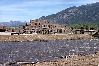
The Rio Pueblo de Taos, also known as Rio Pueblo, is a tributary of the Rio Grande in the U.S. state of New Mexico. From its source in the Sangre de Cristo Mountains it flows about 33 miles (53 km), generally south and west, to join the Rio Grande in the Rio Grande Gorge. On the way the river passes by Taos and through Taos Pueblo.

The Caballo Mountains, are a mountain range located in Sierra and Doña Ana Counties, New Mexico, United States. The range is located east of the Rio Grande and Caballo Lake, and west of the Jornada del Muerto; the south of the range extends into northwest Doña Ana County. The nearest towns are Truth or Consequences and Hatch.
Canada Alamosa, is a term historically applied to four geographical features, all in the same immediate area in southwest Socorro and northwest Sierra Counties, New Mexico. In historical texts the name, Canada Alamosa is applied inter-changeably to the four features, and it is often only the context that distinguishes one feature from the other.

The Rio Brazos is a 42-mile (68 km) long river flowing through northern New Mexico in the United States. It rises in the Tusas Mountains, a subrange of the San Juan Mountains, and runs generally southwest to a confluence with the Rio Chama, part of the larger Rio Grande system.


