Ripponlea railway station

Last updated

Ripponlea
PTV commuter rail station
Ripponleastation3.jpg
Northbound view, November 2021
General information
LocationGlen Eira Road,
Ripponlea, Victoria 3185
City of Port Phillip
Australia
Coordinates 37°52′33″S144°59′42″E / 37.8759°S 144.9951°E / -37.8759; 144.9951
Owned by VicTrack
Operated by Metro Trains
Line(s) Sandringham
Distance9.83 kilometres from
Southern Cross
Platforms2 side
Tracks2
Connections
  • Victoria bus logo.svg Bus
  • Melbourne tram logo.svg Tram
Construction
Structure typeGround
Bicycle facilitiesYes
AccessibleYes—step free access
Other information
StatusOperational, host station
Station codeRIP
Fare zone Myki Zone 1
Website Public Transport Victoria
History
Opened1 May 1912;111 years ago (1912-05-01)
Electrified1500 V DC overhead (May 1919)
Passengers
2005–2018 numbers
2005–2006544,171 [1]
Preceding station Melbourne train logo.svg Metro Trains Following station
Balaclava Sandringham line Elsternwick
towards Sandringham
Track layout
BSicon MFADEg.svg
BSicon STR.svg
BSicon MFADEg.svg
BSicon STR.svg
BSicon hSTRae(r).svg
BSicon hSTRae(l).svg
BSicon STRg.svg
BSicon STRf.svg
1
BSicon STR+BSr.svg
2
BSicon STR+BSl.svg
BSicon STR+BSr.svg
BSicon STR+BSl.svg
BSicon SKRZ-G2BUE.svg
Glen Eira Road
BSicon STRg.svg
BSicon STRf.svg
BSicon MFADEf.svg
BSicon STR.svg
BSicon MFADEf.svg
BSicon STR.svg

Ripponlea railway station is located on the Sandringham line in Victoria, Australia. It serves the south-eastern Melbourne suburb of Ripponlea, and opened on 1 May 1912. [4]

Contents

The station is located at the up (northern) end of the Glen Eira Road level crossing, with station access from Glen Eira Road, Oak Grove and Morres Street.

History

Opening on 1 May 1912, Ripponlea station, like the suburb itself, was named after the Rippon Lea Estate , which was formed by Frederick Thomas Sargood, businessman and a member of Parliament for the Victorian Legislative Council between 1874–1880 and 1882–1901, and a senator for Victoria between 1901 and 1903. [5] [6]

In 1960, boom barriers replaced interlocked gates at the Glen Eira Road level crossing, [7] with the signal box protecting the level crossing also abolished during that time. [4]

Platforms and services

Ripponlea has two side platforms. Platform 1 has a large weatherboard building, with a smaller weatherboard building on Platform 2. There is a footbridge immediately south of the station buildings, which connects the two platforms, and allows pedestrians to cross the railway tracks.

It is served by Sandringham line trains. [8]

Platform 1:

Platform 2:

CDC Melbourne operates one bus route via Ripponlea station, under contract to Public Transport Victoria:

Yarra Trams operates one route via Ripponlea station:

Related Research Articles

<span class="mw-page-title-main">City of Glen Eira</span> Local government area in Victoria, Australia

The City of Glen Eira is a local government area in Victoria, Australia. It is located in the south-eastern suburbs of Melbourne. It has an area of 39 square kilometres (15.06 sq mi) and has an estimated population of 153,858.

<span class="mw-page-title-main">Glen Iris railway station</span> Railway station in Melbourne, Australia

Glen Iris railway station is a commuter railway station in Glen Iris, a suburb of Melbourne, Victoria, Australia. The station opened on 24 March 1890 as part of the branch line from Burnley to Waverley Road station. The station consists of one island platform accessed by a pedestrian underpass. There is one principal station building located the platform. The single-story building, constructed in 1975 as part of the station's rebuilding, acts as a shelter and has toilet facilities. The station is only partially accessible due to steep access ramps.

<span class="mw-page-title-main">Caulfield, Victoria</span> Suburb of Melbourne, Victoria, Australia

Caulfield is a suburb in Melbourne, Victoria, Australia, 12 kilometres (7.5 mi) south-east of Melbourne's Central Business District, located within the City of Glen Eira local government area. Caulfield recorded a population of 5,748 at the 2021 census.

<span class="mw-page-title-main">Elsternwick, Victoria</span> Suburb of Melbourne, Victoria, Australia

Elsternwick is an inner suburb in Melbourne, Victoria, Australia, 9 km south-east of Melbourne's Central Business District, located within the City of Glen Eira local government area. Elsternwick recorded a population of 10,887 at the 2021 census.

<span class="mw-page-title-main">Richmond railway station, Melbourne</span> Railway station in Melbourne, Australia

Richmond railway station is the junction for the Alamein, Belgrave, Cranbourne, Frankston, Glen Waverley, Lilydale, Pakenham and Sandringham lines in Victoria, Australia. It serves the inner south-eastern Melbourne suburb of Richmond, and it opened on 8 February 1859 as Punt Road. It was renamed Swan Street on 12 December of that year, and renamed Richmond on 1 January 1867.

<span class="mw-page-title-main">Burnley railway station</span> Railway station in Melbourne, Australia

Burnley railway station is the junction for the Lilydale, Belgrave, Alamein and Glen Waverley lines in Victoria, Australia. It serves the inner eastern Melbourne suburb of Burnley, and it opened on 1 May 1880 as Burnley Street. It was renamed Burnley on 1 September 1882.

<span class="mw-page-title-main">Carnegie railway station</span> Railway station in Melbourne, Australia

Carnegie railway station is a commuter railway station located in the suburb of Carnegie, in the southeastern suburbs of Melbourne, Victoria, Australia. The station originally opened in 1879 as Rosstown. The station received its current name in 1909 alongside the renaming of the suburb. The station consists of a single island platform connected to the station concourse on Clayton Road via escalators, lifts and a staircase.

<span class="mw-page-title-main">Prahran railway station</span> Railway station in Melbourne, Australia

Prahran railway station (/pɛ'ræn) is located on the Sandringham line in Victoria, Australia. It serves the south-eastern Melbourne suburb of Prahran, and opened on 22 December 1860 as Greville Street. It was renamed Prahran on 1 January 1867.

<span class="mw-page-title-main">Elsternwick railway station</span> Railway station in Melbourne, Australia

Elsternwick railway station is located on the Sandringham line in Victoria, Australia. It serves the south-eastern Melbourne suburb of Elsternwick, and it opened on 19 December 1859.

<span class="mw-page-title-main">Gardenvale railway station</span> Railway station in Melbourne, Australia

Gardenvale railway station is located on the Sandringham line in Victoria, Australia. It serves the south-eastern Melbourne suburb of Brighton, and it opened on 10 December 1906.

<span class="mw-page-title-main">North Brighton railway station</span> Railway station in Melbourne, Australia

North Brighton railway station is located on the Sandringham line in Victoria, Australia. It serves the south-eastern Melbourne suburb of Brighton, and it opened on 19 December 1859 as Bay Street. It was renamed North Brighton on 1 January 1867, renamed Brighton on 1 December 1908, and renamed North Brighton on 1 January 1920.

<span class="mw-page-title-main">Middle Brighton railway station</span> Railway station in Melbourne, Australia

Middle Brighton railway station is located on the Sandringham line in Victoria, Australia. It serves the south-eastern Melbourne suburb of Brighton, and it opened on 21 December 1861 as Church Street. It was renamed Middle Brighton on 1 January 1867.

<span class="mw-page-title-main">Hampton railway station, Melbourne</span> Railway station in Melbourne, Australia

Hampton railway station is located on the Sandringham line in Victoria, Australia. It serves the south-eastern Melbourne suburb of Hampton, and it opened on 2 September 1887. It was renamed Retreat on 1 October of that year, and was renamed back to Hampton on 10 September 1889.

<span class="mw-page-title-main">Sandringham railway station</span> Railway station in Melbourne, Australia

Sandringham railway station is the terminus of the suburban electrified Sandringham line in Victoria, Australia. It serves the south-eastern Melbourne suburb of Sandringham, and it opened on 2 September 1887.

<span class="mw-page-title-main">Kooyong railway station</span> Railway station in Melbourne, Australia

Kooyong railway station is located on the Glen Waverley line in Victoria, Australia. It serves the eastern Melbourne suburb of Kooyong, and it opened on 24 March 1890.

<span class="mw-page-title-main">Tooronga railway station</span> Railway station in Melbourne, Australia

Tooronga railway station is located on the Glen Waverley line in Victoria, Australia. It serves the eastern Melbourne suburb of Malvern, and opened on 24 March 1890.

<span class="mw-page-title-main">Gardiner railway station</span> Railway station in Melbourne, Australia

Gardiner railway station is a commuter railway station in Glen Iris, a suburb of Melbourne, Victoria, Australia. The station opened on 24 March 1890 as Gardiner, named after pastoralist John Gardiner, who settled near the junction of the Yarra River and Gardiners Creek in 1836. 
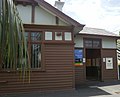
The station consists of two side platforms accessed by a pedestrian concourse. There is one principal station building located on the concourse which serve as bike parking and PSO facilities. This building is single story and opened in 2016 as part of the station rebuild. The station is fully accessible as there are DDA compliant lifts and access ramps provided.

<span class="mw-page-title-main">Mount Waverley railway station</span> Railway station in Melbourne, Australia

Mount Waverley railway station is a commuter railway station in the suburb of Mount Waverley in the south east of Melbourne, Victoria, Australia, and is part of the Glen Waverley line on Melbourne's suburban rail network. The station opened in 1930 as a part of the extension from East Malvern to Glen Waverley. The station consists of two side which are connected to each other via the adjacent roads, additionally both platforms are connected to each other via a pedestrian subway. Additionally the station is served by bus routes 623 and 733. The station is appromixately 18 kilometres (11 mi) or around a 30 minute train ride away from Flinders Street.

<span class="mw-page-title-main">Glen Waverley railway station</span> Commuter railway station in Melbourne, Australia

Glen Waverley railway station is a commuter railway station located in the suburb of Glen Waverley in the south east of Melbourne, Victoria in Australia. The station originally opened in 1930 as part of the line's extension from East Malvern. The station consists of a single island platform which is connected to Kingsway via a ramp on the station's eastern end.

<span class="mw-page-title-main">Ripponlea</span> Suburb of Melbourne, Victoria, Australia

Ripponlea is an inner suburb in Melbourne, Victoria, Australia, 7 km south-east of Melbourne's Central Business District, located within the City of Port Phillip local government area. Ripponlea recorded a population of 1,532 at the 2021 census.

References

  1. 1 2 3 4 Estimated Annual Patronage by Network Segment Financial Year 2005-2006 to 2018-19 Department of Transport
  2. 1 2 3 4 5 6 7 8 9 10 11 12 Railway station and tram stop patronage in Victoria for 2008-2021 Philip Mallis
  3. Annual metropolitan train station patronage (station entries) Data Vic
  4. 1 2 "Ripponlea". vicsig.net. Retrieved 20 January 2023.
  5. "Ripponlea". Victorian Places. Retrieved 20 January 2023.
  6. First, Jamie (7 January 2014). "The A-Z story of Melbourne's suburbs". Herald Sun . Retrieved 20 January 2023.
  7. John Sinnatt (January 1990). "Level Crossing Protection". Somersault. Signalling Record Society Victoria. pp. 9–17.
  8. "Sandringham Line". Public Transport Victoria.
  9. "623 Glen Waverley - St Kilda via Mount Waverley & Chadstone & Carnegie". Public Transport Victoria.
  10. "67 Melbourne University - Carnegie". Public Transport Victoria.