Rivolta d'Adda | |
---|---|
Comune | |
Comune di Rivolta d'Adda | |
![]() | |
Coordinates: 45°28′N9°31′E / 45.467°N 9.517°E | |
Country | Italy |
Region | Lombardy |
Province | Cremona (CR) |
Government | |
• Mayor | Fabio Calvi |
Area | |
• Total | 30 km2 (10 sq mi) |
Elevation | 101 m (331 ft) |
Population (31 December 2014 [1] ) | |
• Total | 8,089 |
• Density | 270/km2 (700/sq mi) |
Demonym(s) | Rivoltani |
Time zone | CET (UTC+1) |
• Summer (DST) | CEST (UTC+2) |
Postal code | 26027 |
Dialing code | 0363 |
Website | Official website |
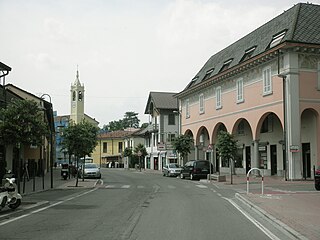
Rivolta d'Adda is a comune (municipality) in the Province of Cremona in the Italian region Lombardy, located about 25 kilometres (16 mi) east of Milan and about 70 kilometres (43 mi) northwest of Cremona.
The comune is a basic administrative division in Italy, roughly equivalent to a township or municipality.
The Province of Cremona is a province in the Lombardy region of Italy. Its capital city is Cremona.
Italy, officially the Italian Republic, is a country in Europe. Located in the middle of the Mediterranean Sea, Italy shares open land borders with France, Switzerland, Austria, Slovenia and the enclaved microstates San Marino and Vatican City. Italy covers an area of 301,340 km2 (116,350 sq mi) and has a largely temperate seasonal and Mediterranean climate. With around 61 million inhabitants, it is the fourth-most populous EU member state and the most populous country in Southern Europe.
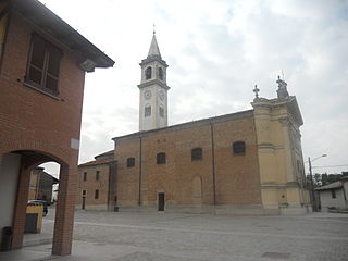
Rivolta d'Adda borders the following municipalities: Agnadello, Arzago d'Adda, Casirate d'Adda, Cassano d'Adda, Comazzo, Merlino, Pandino, Spino d'Adda, Truccazzano. Sights include the church of San Sigismondo (11th century), the church of Santa Maria Immacolata (15th century), a Prehistoric Park with a museum and reconstruction of extinct prehistoric creatures.
Agnadello is a comune and village in the province of Cremona, Lombardy, northern Italy. It was the location of the battle of Agnadello in which Louis XII of France defeated the Venetians on 14 May 1509.
Arzago d'Adda is a comune (municipality) in the Province of Bergamo in the Italian region of Lombardy, located about 30 kilometres (19 mi) east of Milan and about 25 kilometres (16 mi) southwest of Bergamo.
Casirate d'Adda is a comune (municipality) in the Province of Bergamo in the Italian region of Lombardy, located about 30 kilometres (19 mi) east of Milan and about 25 kilometres (16 mi) southwest of Bergamo.
Prehistoric Park, themed nature park located on the outskirts of the town itself, within the Adda Park.
The Prehistoric Park is an Italian naturalistic park of more than 100 hectares of secular wood, situated on the outskirts of the Rivolta d'Adda commune, Cremona province, about 20 kilometers east of Milan. The park is adjacent to the homonym Adda river and contains 30 reconstructions of prehistoric animals, a hundred semi-liberty wild animals, a botanical itinerary with plants signalled, natural environments, picnic reggeds areas, a café, playing parks, a labyrinth, and shows of fossils, etc., all along a shaded course. The access to the park is exclusively pedestrian, but access is allowed to bicycles and dogs with leashes. The park is also recognized by various national and local corporate bodies that testify to the validity of the structure as a guide to the environmental education, not only to children, but of adults as well.
Acquanegra Cremonese is a comune (municipality) in the Province of Cremona in the Italian region Lombardy, located about 70 kilometres (43 mi) southeast of Milan and about 12 kilometres (7 mi) northwest of Cremona.
Capralba is a comune (municipality) in the Province of Cremona in the Italian region Lombardy, located about 40 kilometres (25 mi) east of Milan and about 45 kilometres (28 mi) northwest of Cremona.
Casaletto Ceredano is a comune (municipality) in the Province of Cremona in the Italian region Lombardy, located about 40 kilometres (25 mi) southeast of Milan and about 40 kilometres (25 mi) northwest of Cremona.
Credera Rubbiano is a comune (municipality) in the Province of Cremona in the Italian region Lombardy, located about 45 kilometres (28 mi) southeast of Milan and about 35 kilometres (22 mi) northwest of Cremona. It was created in 1928 through the merger of the former communes of Credera and Rubbiano.
Crotta d'Adda is a comune (municipality) in the Province of Cremona in the Italian region Lombardy, located about 60 kilometres (37 mi) southeast of Milan and about 15 kilometres (9.3 mi) west of Cremona.
Dovera is a comune (municipality) in the Province of Cremona in the Italian region Lombardy, located about 30 kilometres (19 mi) southeast of Milan and about 45 kilometres (28 mi) northwest of Cremona.
Formigara is a comune (municipality) in the Province of Cremona in the Italian region Lombardy, located about 50 kilometres (31 mi) southeast of Milan and about 25 kilometres (16 mi) northwest of Cremona.
Gombito is a comune (municipality) in the Province of Cremona in the Italian region Lombardy, located about 50 kilometres (31 mi) southeast of Milan and about 30 kilometres (19 mi) northwest of Cremona.
Grumello Cremonese ed Uniti is a comune (municipality) in the Province of Cremona in the Italian region Lombardy, located about 60 kilometres (37 mi) southeast of Milan and about 15 kilometres (9.3 mi) northwest of Cremona. Grumello Cremonese ed Uniti borders the following municipalities: Acquanegra Cremonese, Annicco, Cappella Cantone, Crotta d'Adda, Pizzighettone, Sesto ed Uniti.
Pandino is a comune (municipality) in the Province of Cremona in the Italian region Lombardy, located about 30 kilometres (19 mi) east of Milan and about 50 kilometres (31 mi) northwest of Cremona.
Spinadesco is a comune (municipality) in the Province of Cremona in the Italian region Lombardy, located about 70 kilometres (43 mi) southeast of Milan and about 8 kilometres (5 mi) west of Cremona.
Spino d'Adda is a comune (municipality) in the Province of Cremona in the Italian region Lombardy, located about 25 kilometres (16 mi) southeast of Milan and about 50 kilometres (31 mi) northwest of Cremona.
Vailate is a comune (municipality) in the Province of Cremona in the Italian region Lombardy, located about 35 kilometres (22 mi) east of Milan and about 50 kilometres (31 mi) northwest of Cremona. As of 31 December 2004, it had a population of 4,299 and an area of 9.8 square kilometres (3.8 sq mi).
Caorso is a comune (municipality) in the Province of Piacenza in the Italian region Emilia-Romagna, located about 130 kilometres (81 mi) northwest of Bologna and about 13 kilometres (8 mi) east of Piacenza.
Monticelli d'Ongina is a comune (municipality) in the Province of Piacenza in the Italian region Emilia-Romagna, located about 130 kilometres (81 mi) northwest of Bologna and about 20 kilometres (12 mi) east of Piacenza.
Imbersago is a comune (municipality) in the Province of Lecco in the Italian region Lombardy, located in the Brianza traditional area about 35 kilometres (22 mi) northeast of Milan and about 15 kilometres (9 mi) south of Lecco.
Comazzo is a comune (municipality) in the Province of Lodi in the Italian region Lombardy, located about 20 kilometres (12 mi) east of Milan and about 20 kilometres (12 mi) northwest of Lodi.
Maccastorna is a comune (municipality) in the Province of Lodi in the Italian region Lombardy, located about 50 kilometres (31 mi) southeast of Milan and about 20 kilometres (12 mi) southeast of Lodi.
Merlino is a comune (municipality) in the Province of Lodi in the Italian region Lombardy, located about 25 kilometres (16 mi) east of Milan and about 15 kilometres (9 mi) north of Lodi. As of 31 December 2004, it had a population of 1,360 and an area of 10.9 square kilometres (4.2 sq mi).
![]() | This article on a location in the Province of Cremona is a stub. You can help Wikipedia by expanding it. |