Roby Mill

Last updated
Roby Mill
Village
Roby Mill from the Parbold Viewpoint - geograph.org.uk - 161176.jpg
Roby Mill as seen from Parbold
Location map United Kingdom Borough of West Lancashire.svg
Red pog.svg
Roby Mill
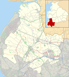
Shown within West Lancashire
Lancashire UK location map.svg
Red pog.svg
Roby Mill
Location within Lancashire
Population405 
OS grid reference SD5107
  London 174 mi (280 km) SE
Civil parish
District
Shire county
Region
Country England
Sovereign state United Kingdom
Post town Skelmersdale
Postcode district WN8
Dialling code 01695
Police Lancashire
Fire Lancashire
Ambulance North West
UK Parliament
List of places
UK
England
Lancashire
53°33′32″N2°43′45″W / 53.558861°N 2.7292419°W / 53.558861; -2.7292419

Roby Mill is a village in the West Lancashire district of Lancashire, England. The estimated population is 405. [1]

Contents

Geography and Politics

Roby Mill is located in the West Lancashire district of Lancashire, and the civil parish of Up Holland, formerly part of the unparished area of Skelmersdale. It is located approximately 6.5 miles (10.5 km) east of Ormskirk town centre, the administrative centre for West Lancashire, 2 miles (3.2 km) east of Skelmersdale town centre, 13.7 miles (22.0 km) south of Preston city centre, the administrative centre of Lancashire and 182.2 miles (293.2 km) north-west of London.

It falls under West Lancashire Borough Council and Lancashire County Council, both of which are responsible for the administration of various services in the area. [2] It is located in the Wrightington ward of West Lancashire Borough Council, where it is represented by two Conservative Party councillors [3] and in the Skelmersdale North ward of Lancashire County Council, where it is represented by one Labour Party councillor. [4]

It is in the West Lancashire parliamentary constituency, which has been represented by Labour Party MPs since the 1992 general election, namely Colin Pickthall, Rosie Cooper, and since 2023 Ashley Dalton.

Transport

The B5375 road runs through the village, connecting the town to Appley Bridge approximately 2 miles (3.2 km) to the north, and to Up Holland approximately 1.2 miles (1.9 km) to the south.

Preston Bus operates the 311 service which runs through the village, connecting Ormskirk bus station to Wrightington Hospital. [5]

Education

The village is served by one Church of England primary school.

Related Research Articles

<span class="mw-page-title-main">Lancashire</span> County of England

Lancashire is a ceremonial county in North West England. It is bordered by Cumbria to the north, North Yorkshire and West Yorkshire to the east, Greater Manchester and Merseyside to the south, and the Irish Sea to the west.

<span class="mw-page-title-main">Ormskirk</span> Market town in Lancashire, England

Ormskirk is a market town in the West Lancashire district of Lancashire, England. It is located 13 miles (21 km) north of Liverpool, 11 miles (18 km) northwest of St Helens, 9 miles (14 km) southeast of Southport and 18 miles (29 km) southwest of Preston. Ormskirk is known for its gingerbread. In 2011 it had a population of 24,073.

<span class="mw-page-title-main">Metropolitan Borough of Knowsley</span> Metropolitan borough in England

The Metropolitan Borough of Knowsley is a metropolitan borough in Merseyside, North West England. It covers several towns and villages, including Kirkby, Prescot, Huyton, Whiston, Halewood, Cronton and Stockbridge Village; Kirkby, Huyton, and Prescot being the major commercial centres. It takes its name from the village of Knowsley, though its headquarters are in Huyton. It forms part of the wider Liverpool City Region.

<span class="mw-page-title-main">Parbold</span> Human settlement in England

Parbold is a village and civil parish in West Lancashire, England.

<span class="mw-page-title-main">West Lancashire</span> District of Lancashire, England

West Lancashire is a local government district with borough status in Lancashire, England. The council is based in Ormskirk, and the largest town is Skelmersdale. The district borders Fylde to the north, over the Ribble Estuary; South Ribble, Chorley, and Wigan to the east; St Helens and Knowsley to the south; and Sefton to the south and west.

<span class="mw-page-title-main">Poulton-le-Fylde</span> Human settlement in England

Poulton-le-Fylde, commonly shortened to Poulton, is a market town in Lancashire, England, situated on the coastal plain called the Fylde. In the 2021 United Kingdom census, it had a population of 18,115.

<span class="mw-page-title-main">Metropolitan Borough of St Helens</span> Metropolitan borough in England

The Metropolitan Borough of St Helens is a local government district with borough status in Merseyside, North West England. The borough is named after its largest settlement, St Helens, but also includes neighbouring towns and villages such as Earlestown, Rainhill, Eccleston, Clock Face, Haydock, Billinge, Garswood, Rainford and Newton-le-Willows.

<span class="mw-page-title-main">Scarisbrick</span> Human settlement in England

Scarisbrick is a village and civil parish in West Lancashire, England. The A570, the main road between Ormskirk and Southport, runs through Scarisbrick, and much of the village lies along it. As a result, it does not have a traditional village centre, though the junction with the A5147 is close to the geographic centre.

<span class="mw-page-title-main">Burscough</span> Town in West Lancashire, England

Burscough is a town and civil parish in the district of West Lancashire, Lancashire, England. The town is located approximately 13.5 miles (21.7 km) north-northeast of Liverpool and 13 miles (21 km) southwest of Preston. Its northern part is called Burscough Bridge, and was originally a separate settlement.

<span class="mw-page-title-main">West Lancashire (UK Parliament constituency)</span> Parliamentary constituency in the United Kingdom, 1983 onwards

West Lancashire is a county constituency represented in the House of Commons of the UK Parliament. Following the resignation of Labour MP Rosie Cooper on 30 November 2022, the seat was won by the party's candidate Ashley Dalton in the by-election held on 9 February 2023.

The Skelmersdale branch was a standard gauge railway (SKE) which connected the Liverpool, Ormskirk and Preston Railway at Ormskirk with Rainford Junction via Skelmersdale. At Rainford it connected with the Liverpool and Bury Railway and the St. Helens Railway. It was built by the East Lancashire Railway, which was taken over by the Lancashire and Yorkshire Railway shortly afterward. The steam railmotor which served the line was sometimes known locally as the "Skem Dodger" and other times as the "Skem Jazzer".

<span class="mw-page-title-main">Skelmersdale railway station</span> Former railway station in England

Skelmersdale railway station was a station located on the Skelmersdale branch at Skelmersdale, England. The station was originally named Blague Gate, having its name changed to Skelmersdale on 8 August 1874 and carried passengers from 1858 to 1956.

<span class="mw-page-title-main">Skelmersdale</span> Town in England

Skelmersdale is a town in the West Lancashire district, in Lancashire, England, on the River Tawd, 6 miles (10 km) west of Wigan, 13 miles (21 km) northeast of Liverpool and 15 miles (24 km) southwest of Preston. In 2006, it had a population of 38,813. The town is known locally as Skem.

The 2010 West Lancashire Borough Council election took place on 6 May 2010 to elect members of West Lancashire Borough Council in Lancashire, England. One third of the council was up for election and the Conservative Party stayed in overall control of the council.

<span class="mw-page-title-main">Hilldale, Lancashire</span> Human settlement in England

Hilldale is a civil parish in the West Lancashire district of Lancashire, England, containing the village of Hill Dale and the neighbouring hamlet of Andertons Mill. Formerly part of Wrightington, Hilldale became a separate civil parish in 1999. As of 2011, Hilldale has a population of 581.

<span class="mw-page-title-main">Westhead</span> Village in England

Westhead is a village in the West Lancashire district of Lancashire, England. As of 2014, the estimated population was 886.

<span class="mw-page-title-main">Our West Lancashire</span> Localist group of independent politicians in West Lancashire

Our West Lancashire (OWL) is a localist political party in West Lancashire, United Kingdom. As of May 2021 it held 7 seats on West Lancashire Borough Council. The party also unsuccessfully contested seats in West Lancashire on Lancashire County Council, as well. The group claims to have drawn members from all of the major parties in West Lancashire, and claims to "put residents before the party whip". It is one of two localist parties in West Lancashire, alongside Skelmersdale Independent Party.

A by-election for the United Kingdom parliamentary constituency of West Lancashire was held on 9 February 2023, following the resignation of incumbent member of Parliament Rosie Cooper. She announced her resignation in order to take up the job as chair of Mersey Care NHS Foundation Trust. Ashley Dalton held the seat for Labour.

References

  1. "Area information for Roby Mill, Skelmersdale". Archived from the original on 18 October 2020. Retrieved 17 October 2020.
  2. "Home". Lancashire County Council. Archived from the original on 13 October 2020. Retrieved 17 October 2020.
  3. "Your Councillors". West Lancashire Borough Council. Archived from the original on 17 October 2020. Retrieved 17 October 2020.
  4. "Your Councillors". Lancashire County Council. Archived from the original on 18 October 2020. Retrieved 17 October 2020.
  5. "Roby Mill". bustimes.org. Archived from the original on 18 October 2020. Retrieved 17 October 2020.