
A canyon or gorge is a deep cleft between escarpments or cliffs resulting from weathering and the erosive activity of a river over geologic timescales. Rivers have a natural tendency to cut through underlying surfaces, eventually wearing away rock layers as sediments are removed downstream. A river bed will gradually reach a baseline elevation, which is the same elevation as the body of water into which the river drains. The processes of weathering and erosion will form canyons when the river's headwaters and estuary are at significantly different elevations, particularly through regions where softer rock layers are intermingled with harder layers more resistant to weathering.

Rock Island County is a county located in the U.S. state of Illinois, bounded on the west by the Mississippi River. According to the 2010 census, it had a population of 147,546. Its county seat is Rock Island; its largest city is neighboring Moline.

Carbon Cliff is a village in Rock Island County, Illinois, United States. The population was 1,689 at the 2000 census. It lies in the south part of Hampton Township.

Englewood Cliffs is a borough in Bergen County, New Jersey, United States. As of the 2010 United States Census, the borough's population was 5,281, reflecting a decline of 41 (-0.8%) from the 5,322 counted in the 2000 Census, which had in turn declined by 312 (-5.5%) from the 5,634 counted in the 1990 Census.

James Chambers, OM, known professionally as Jimmy Cliff, is a Jamaican ska and reggae musician, multi-instrumentalist, singer, and actor. Along with Bunny Wailer he is one of only two living musicians to hold the Order of Merit, the highest honour that can be granted by the Jamaican government for achievements in the arts and sciences.

In geography and geology, a cliff is a vertical, or nearly vertical, rock exposure. Cliffs are formed as erosion landforms by the processes of weathering and erosion. Cliffs are common on coasts, in mountainous areas, escarpments and along rivers. Cliffs are usually formed by rock that is resistant to weathering and erosion. Sedimentary rocks most likely to form cliffs include sandstone, limestone, chalk, and dolomite. Igneous rocks such as granite and basalt also often form cliffs.

Maiden Rock is a village in Pierce County, Wisconsin, United States. The population was 119 at the 2010 census. The village is located within the Town of Maiden Rock.
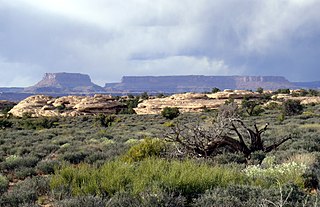
Mesa is the American English term for tableland, an elevated area of land with a flat top and sides that are usually steep cliffs. It takes its name from its characteristic table-top shape. It may also be called a table hill, table-topped hill or table mountain. It is larger than a butte, which it otherwise resembles closely.

Pictured Rocks National Lakeshore is a U.S. National Lakeshore on the shore of Lake Superior in the Upper Peninsula of Michigan, United States. It extends for 42 miles (67 km) along the shore and covers 73,236 acres. The park has extensive views of the hilly shoreline between Munising and Grand Marais in Alger County, Michigan, with picturesque rock formations, waterfalls, and sand dunes.

Sun Lakes-Dry Falls State Park is a public recreation area located at the foot of Dry Falls, three miles west of Coulee City in Grant County, Washington. The state park covers 3,774 acres (1,527 ha) along Route 17 at the head of the Lower Grand Coulee. A privately owned golf course and resort, Sun Lakes Park Resort, is located near the park entrance and Park Lake.
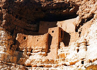
In archeology, cliff dwellings are dwellings formed by using niches or caves in high cliffs, with more or less excavation or with additions in the way of masonry.
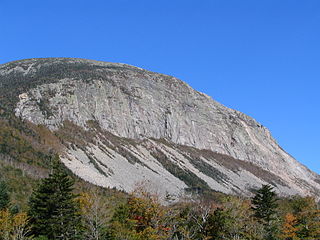
Cannon Mountain is a 4,080-foot (1,240 m) peak in the White Mountains of New Hampshire. It is known for both its technical rock and ice climbing on its cliff face and skiing at Cannon Mountain Ski Area. It was also home to the Old Man of the Mountain, until that formation collapsed on May 3, 2003.

"Rock Bottom" is the 35th episode of the first season of the American animated television series SpongeBob SquarePants. It originally was produced in 1999 and aired on Nickelodeon in the United States on March 15, 2000. The series follows the adventures of the title character in the underwater city of Bikini Bottom. In the episode, SpongeBob becomes stranded in an abyssopelagic zone that is a city called Rock Bottom.

The Palatki Heritage Site is an archaeological site and park located in the Coconino National Forest, near Sedona, in Arizona, United States. In the Hopi language Palatki means 'red house'.

"Do You Want to Dance" is a song written by American singer Bobby Freeman and recorded by him in 1958. It reached number No. 5 on the United States Billboard Top 100 Sides pop chart and No. 2 on the Billboard R&B chart. Cliff Richard and the Shadows' version of the song reached No. 2 in the United Kingdom in 1962, despite being a B-side. The Beach Boys' version reached No. 12 as "Do You Wanna Dance?" in the United States in 1965, and a 1972 cover by Bette Midler reached No. 17.

Snow Hill Island is an almost completely snowcapped island, 33 km (21 mi) long and 12 km (7.5 mi) wide, lying off the east coast of the Antarctic Peninsula. It is separated from James Ross Island to the north-east by Admiralty Sound and from Seymour Island to the north by Picnic Passage. It is one of several islands around the peninsula known as Graham Land, which is closer to South America than any other part of the Antarctic continent.
Hanging Rock is a large limestone cliff with an obtuse angle. It is located beside the village of Florencecourt in County Fermanagh, Northern Ireland, and is part of the Cuilcagh mountain region. The cliff is situated in an area dedicated The Hanging Rock Nature Reserve, which is in turn part of the Marble Arch Caves Global Geopark.
Martin Charles Strong is a Scottish music historian known for compiling discographies of popular music including The Great Rock Discography. Strong has been described in broadsheet newspaper profiles as a "compiler of acclaimed mammoth discographies" and "a man who knows more about rock music than is healthy for one individual".

Lincoln Rock State Park is a public recreation area on the east side of the Columbia River's Lake Entiat, seven miles (11 km) north of Wenatchee and one mile upstream from the Rocky Reach Dam. The state park covers 86 acres (35 ha) opposite the cliff formation for which it is named. The park provides views of the south end of Swakane Canyon and of Turtle Rock Island in Lake Entiat, a 150-acre nature preserve that was isolated from the mainland when the lake formed in the 1960s. The park offers water activities, including fishing, boating, and swimming, in addition to facilities for picnicking, camping, hiking, and field sports. It is managed by the Washington State Parks and Recreation Commission under a lease agreement with the owners, the Chelan County Public Utility District.
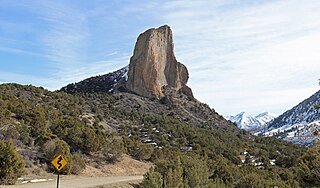
Needle Rock Natural Area is located at the western edge of the West Elk Mountains of Colorado. The surrounding terrain is characterized by laccolithic mountains flanked by precipitous cliffs, extensive talus aprons, forested mesas, canyons, and spacious, well-watered intermontane basins. Needle Rock is an intrusive plug of monzonite porphyry cropping out 3.5 miles (5.6 km) east-northeast of the Town of Crawford in Delta County, Colorado, United States. At an elevation of 7,797 feet (2,377 m), the towering rock spire stands 800 feet (240 m) tall above the floor of the Smith Fork of the Gunnison River valley. The massive rock feature originated in the Oligocene geological epoch when magma intruded between existing sedimentary rocks as the crown of a buried laccolith or possibly the underlying conduit of a laccolith. Subsequent erosion has exposed the prominent rock formation seen in the natural area today.


