Fairlea, West Virginia

Last updated

Fairlea, West Virginia
Fairlea ARPC.jpg
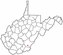
WVMap-doton-Fairlea.PNG
Location of Fairlea, West Virginia
Coordinates: 37°46′32″N80°27′29″W / 37.77556°N 80.45806°W / 37.77556; -80.45806
Country United States
State West Virginia
County Greenbrier
Area
  Total3.7 sq mi (9.6 km2)
  Land3.7 sq mi (9.6 km2)
  Water0.0 sq mi (0.0 km2)
Elevation
[1]
2,159 ft (658 m)
Population
 (2010) [2]
  Total1,747
  Density470/sq mi (180/km2)
Time zone UTC-5 (Eastern (EST))
  Summer (DST) UTC-4 (EDT)
ZIP code
24902
Area code 304
FIPS code 54-26428 [3]
GNIS feature ID2389062 [1]

Fairlea is a census-designated place (CDP) in Greenbrier County, West Virginia, United States. The population was 1,747 at the 2010 census. [2] Fairlea is the location of the annual West Virginia State Fair, held in August.

Contents

Geography

Fairlea is located at 37°46′48″N80°27′31″W / 37.779967°N 80.458538°W / 37.779967; -80.458538 (37.779967, -80.458538). [4]

According to the United States Census Bureau, the CDP has a total area of 3.7 square miles (9.6 km2), all land.

The area Fairlea is located on is relatively flat compared to the rest of the state.

It borders the city of Lewisburg to the north, and the city of Ronceverte to the south.

Demographics

As of the census [3] of 2000, there were 1,706 people, 770 households, and 428 families residing in the CDP. The population density was 461.8 people per square mile (178.5/km2). There were 861 housing units at an average density of 233.1/sq mi (90.1/km2). The racial makeup of the CDP was 96.66% White, 1.17% African American, 0.12% Native American, 0.76% Asian, 0.35% from other races, and 0.94% from two or more races. Hispanic or Latino of any race were 1.41% of the population.

There were 770 households, out of which 24.0% had children under the age of 18 living with them, 42.5% were married couples living together, 10.5% had a female householder with no husband present, and 44.4% were non-families. 39.4% of all households were made up of individuals, and 15.8% had someone living alone who was 65 years of age or older. The average household size was 2.08 and the average family size was 2.78.

In the CDP, the population was spread out, with 19.0% under the age of 18, 9.0% from 18 to 24, 27.3% from 25 to 44, 23.2% from 45 to 64, and 21.5% who were 65 years of age or older. The median age was 41 years. For every 100 females, there were 85.0 males. For every 100 females age 18 and over, there were 79.7 males.

The median income for a household in the CDP was $20,664, and the median income for a family was $28,077. Males had a median income of $20,625 versus $22,281 for females. The per capita income for the CDP was $16,146. About 22.0% of families and 27.4% of the population were below the poverty line, including 44.9% of those under age 18 and 21.0% of those age 65 or over.

Transportation

Major highways

Related Research Articles

<span class="mw-page-title-main">Mission, Oregon</span> Unincorporated community in the state of Oregon, United States

Mission is an unincorporated community in Umatilla County, Oregon, United States. For statistical purposes, the United States Census Bureau has defined Mission as a census-designated place (CDP). The population was 1,019 at the 2000 census.

<span class="mw-page-title-main">Bellwood, Virginia</span> CDP in Virginia, United States

Bellwood is a census-designated place (CDP) in Chesterfield County, Virginia, United States. The population was 6,352 at the 2010 census. The community takes its name from Bellwood, one of the James River Plantations.

<span class="mw-page-title-main">Dumbarton, Virginia</span> Census-designated place in Virginia

Dumbarton is a census-designated place (CDP) in Henrico County, Virginia, United States. The population was 7,879 at the 2010 census.

<span class="mw-page-title-main">Lakeside, Virginia</span> Census-designated area in Virginia

Lakeside is a census-designated place (CDP) in Henrico County, Virginia, United States. It is an inner suburb of Richmond, Virginia. The population was 12,203 at the 2020 census.

<span class="mw-page-title-main">Montrose, Virginia</span> Census-designated place in Virginia

Montrose is a census-designated place (CDP) in Henrico County, Virginia, United States. The population was 7,909 at the 2020 census.

Merrimac is a census-designated place (CDP) in Montgomery County, Virginia, United States. The population was 2,133 at the 2010 census. It is part of the Blacksburg–Christiansburg Metropolitan Statistical Area which encompasses all of Montgomery County and the city of Radford.

Fairlawn is a census-designated place (CDP) in Pulaski County, Virginia, United States. The population was 2,419 at the 2020 census up from 2,367 at the 2010 census. It is served by the Radford, Virginia post office and is located on the opposite side of the New River from Radford.

Cave Spring is a census-designated place (CDP) in Roanoke County, Virginia, United States. The population was 26,755 at the 2020 census. Cave Spring covers much of the area known locally as "Southwest County" which has the most affluent suburbs of Roanoke. It is part of the Roanoke Metropolitan Statistical Area.

<span class="mw-page-title-main">Mallory, West Virginia</span> Census-designated place in West Virginia, United States

Mallory is a census-designated place (CDP) in Logan County, West Virginia, United States. The population was 1,654 at the 2010 census. The CDP contains the unincorporated communities, from west to east, of Huff Junction, Mallory, Davin, Mineral City, Claypool, Combs Addition, and Gillman Bottom.

<span class="mw-page-title-main">Chattaroy, West Virginia</span> Census-designated place in West Virginia, United States

Chattaroy is a census-designated place (CDP) in Mingo County, West Virginia, United States. The population was 756 at the 2010 census.

<span class="mw-page-title-main">Red Jacket, West Virginia</span> Census-designated place in West Virginia, United States

Red Jacket is a census-designated place (CDP) in Mingo County, West Virginia, United States. The population was 581 at the 2010 census. The community was named for Red Jacket, a Seneca chief.

Cassville is a census-designated place (CDP) in Monongalia County, West Virginia, United States. The population was 1,268 at the 2020 census. It is included in the Morgantown, West Virginia Metropolitan Statistical Area. Cassville was named after Lewis Cass, a prominent American statesman who served as Secretary of War, Secretary of State, and Governor of Michigan.

<span class="mw-page-title-main">Bradley, West Virginia</span> Census-designated place in West Virginia, United States

Bradley is a census-designated place (CDP) in Raleigh County, West Virginia, United States, named in honor of General Omar Bradley, a field commander in North Africa and Europe during World War II and a General of the Army. The population was 1,928 at the 2020 census.

<span class="mw-page-title-main">Coal City, West Virginia</span> Census-designated place in West Virginia, United States

Coal City is a census-designated place (CDP) in Raleigh County, West Virginia, United States. The population was 1,815 at the 2010 census. Coal City's population is composed of other surrounding unincorporated communities.

<span class="mw-page-title-main">Daniels, West Virginia</span> Census-designated place in West Virginia, United States

Daniels is a census-designated place (CDP) in Raleigh County, West Virginia, United States. The population was 1,881 at the 2010 census.

<span class="mw-page-title-main">MacArthur, West Virginia</span> Census-designated place in West Virginia, United States

MacArthur is a census-designated place (CDP) in Raleigh County, West Virginia, United States. Originally, it was named Hollywood and renamed MacArthur after General of the Army Douglas MacArthur in 1942. The population was 1,500 at the 2010 census.

<span class="mw-page-title-main">Piney View, West Virginia</span> Census-designated place in West Virginia, United States

Piney View is a census-designated place (CDP) in Raleigh County, West Virginia, United States. The population was 989 at the 2010 census.

<span class="mw-page-title-main">Prosperity, West Virginia</span> Census-designated place in West Virginia, United States

Prosperity is a census-designated place (CDP) in Raleigh County, West Virginia, United States. The population was 1,498 at the 2010 census.

Hollins is a census-designated place (CDP) in Botetourt and Roanoke County, Virginia, United States. Hollins covers much of the area known locally as "North County". The population was 15,574 at the 2020 census. It is part of the Roanoke Metropolitan Statistical Area. The area is also the home of Hollins University in addition to four properties listed on the National Register of Historic Places: the Black Horse Tavern-Bellvue Hotel and Office, Harshbarger House, the Hollins College Quadrangle, and Old Tombstone.

Fryeburg is a census-designated place (CDP) in the town of Fryeburg in Oxford County, Maine, United States. The population was 1,444 at the 2020 census.

References

  1. 1 2 U.S. Geological Survey Geographic Names Information System: Fairlea, West Virginia
  2. 1 2 "U.S. Census website". United States Census Bureau . Retrieved May 14, 2011.
  3. 1 2 "U.S. Census website". United States Census Bureau . Retrieved January 31, 2008.
  4. "US Gazetteer files: 2010, 2000, and 1990". United States Census Bureau. February 12, 2011. Retrieved April 23, 2011.