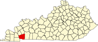
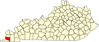
Trigg County is a county located on the far southwestern border of the U.S. state of Kentucky. As of the 2010 census, the population was 14,339. Its county seat is Cadiz. Formed in 1820, the county was named for Stephen Trigg, an officer in the American Revolutionary War who was killed at the Battle of Blue Licks, now in Robertson County, Kentucky. It was a victory for British and allied troops.

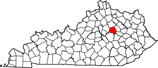
Rockcastle County is a county located in the U.S. state of Kentucky. As of the 2010 census, the population was 17,056. Its county seat is Mt. Vernon. The county founded in 1810 and named for the Rockcastle River which runs through it. The river, in turn, is named for its majestic rock cliffs.

The Clarksville Metropolitan Statistical Area is defined by the United States Census Bureau as an area consisting of four counties – two in Tennessee and two in Kentucky – anchored by the city of Clarksville, Tennessee. A July 1, 2018 estimate placed the population at 305,825. As of 2009, the Clarksville Metropolitan Statistical Area is the 167th largest MSA in the United States.

The Rockcastle River is a 54.8-mile-long (88.2 km) river primarily in Rockcastle County, Kentucky, United States. It is a tributary of the Cumberland River and therefore, via the Ohio River, part of the Mississippi River watershed. In 1750 it was discovered and named the Lawless River by Dr. Thomas Walker and his exploring party. It was soon renamed by hunter Isaac Lindsey for its castle-like rock formations. It is about 60 to 80 feet wide throughout its length. The river has an important native walleye population that has stabilized in recent years. A trip down the lower Rockcastle is one of the most remote trips into the Appalachian wilderness you can have without hiking the Appalachian Trail.

Rock Castle is an unincorporated community in southwestern Jackson County, West Virginia, United States. It lies along Rock Castle Road south of the city of Ripley, the county seat of Jackson County. Its elevation is 705 feet (215 m).

This is a list of the National Register of Historic Places listings in Hardin County, Kentucky.

This is a list of the National Register of Historic Places listings in Boyle County, Kentucky.
This is a list of the National Register of Historic Places listings in Clark County, Kentucky.

This is a list of the National Register of Historic Places listings in Powell County, Kentucky.

This is a list of the National Register of Historic Places listings in Nelson County, Kentucky.

This is a list of the National Register of Historic Places listings in Jessamine County, Kentucky.
Rock Castle or Rockcastle may refer to:

This is a list of the National Register of Historic Places listings in Ballard County, Kentucky.

This is a list of the National Register of Historic Places listings in Clay County, Kentucky.
This is a list of the National Register of Historic Places listings in Hickman County, Kentucky.

This is a list of the National Register of Historic Places listings in Marshall County, Kentucky.

This is a list of the National Register of Historic Places listings in Rockcastle County, Kentucky.

This is a list of the National Register of Historic Places listings in Trigg County, Kentucky.
Roundstone is an unincorporated community in Rockcastle County, in the U.S. state of Kentucky.
Kentucky Route 276 (KY 276) is a 17.7-mile-long (28.5 km) state highway in the U.S. state of Kentucky. The highway connects mostly rural areas of Trigg and Caldwell counties with the extreme eastern part of Cadiz.