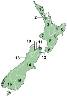
New Zealand is divided into sixteen regions for local government purposes. Eleven are administered by regional councils, and five are administered by unitary authorities, which are territorial authorities that also perform the functions of regional councils. The Chatham Islands Council is similar to a unitary authority, authorised under its own legislation.

The Wellington Region is a local-government region of New Zealand that occupies the southern end of the North Island. The region covers an area of 8,049 square kilometres (3,108 sq mi), and has a population of 542,000.

Territorial authorities are the second tier of local government in New Zealand, below regional councils. There are 67 territorial authorities: 13 city councils, 53 district councils and the Chatham Islands Council. District councils serve a combination of rural and urban communities, while city councils administer the larger urban areas. Five territorial authorities also perform the functions of a regional council and thus are unitary authorities. The Chatham Islands Council is a sui generis territorial authority that is similar to a unitary authority.

The Northland Region is the northernmost of New Zealand's 16 local government regions. New Zealanders sometimes refer to it as the Winterless North because of its mild climate. The main population centre is the city of Whangārei, and the largest town is Kerikeri. At the 2018 New Zealand census Northland recorded a surprising population growth spurt of 18.1% since the previous 2013 census, placing it as the fastest growing region of New Zealand, ahead of other strong growth regions such as the Bay of Plenty and Waikato.
The North Shore is a part of the urban area of Auckland, New Zealand, located to the north of the Waitematā Harbour. From 1989 until 2010, North Shore City was an independent city within the Auckland Region.

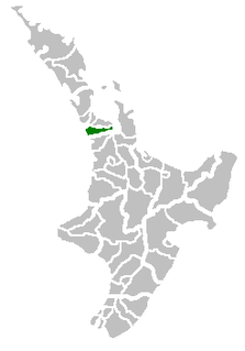
Rodney District was a local government area in the northernmost part of New Zealand's Auckland Region from 1989 to 2010. It included Kawau Island. It was created from the amalgamation of Helensville Borough and Rodney County in 1989. The seat of Rodney District Council was at Orewa. Rodney District and Rodney County each took their names from Cape Rodney, which Captain James Cook named on 24 November 1769 after Admiral Sir George Brydges Rodney.
Franklin District was a New Zealand territorial authority that lay between the Auckland metropolitan area and the Waikato Plains. As a formal territory it was abolished on 31 October 2010 and divided between Auckland Council in the Auckland Region to the north and Waikato and Hauraki districts in the Waikato region to the south and east. The Auckland portion is now part of the Franklin ward, which also includes rural parts of the former Manukau City.

Waiheke Island is the most populated and the second-largest island in the Hauraki Gulf of New Zealand. Its ferry terminal in Matiatia Bay at the western end is 21.5 km (13.4 mi) from the central-city terminal in Auckland.

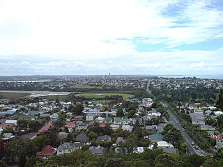
Warkworth is a town on the Northland Peninsula in the upper North Island of New Zealand. It is in the northern part of the Auckland Region. It is located on State Highway 1, 64 km north of Auckland and 98 km south of Whangarei, and is at the head of Mahurangi Harbour.

The Catlins comprises an area in the southeastern corner of the South Island of New Zealand. The area lies between Balclutha and Invercargill, straddling the boundary between the Otago and Southland regions. It includes the South Island's southernmost point, Slope Point.

Whangaparaoa Peninsula or Whangaparāoa Peninsula is a suburban area about 25 km north of Auckland, New Zealand. It had 30,672 residents in 2013, many of them in the eponymous town of Whangaparaoa on its southern side. It is part of the Hibiscus Coast.

The Rangitikei District is a territorial authority located primarily in the Manawatū-Whanganui region in the North Island of New Zealand, although a small part, the town of Ngamatea, lies in the Hawke's Bay Region. It is located in the southwest of the island, and follows the catchment area of the Rangitīkei River.
The Hibiscus Coast is a stretch of the Hauraki Gulf coast located in New Zealand's Auckland Region. It is the 10th largest urban area in New Zealand, and the second largest in the Auckland Region behind Auckland itself.

State Highway 1 is the longest and most significant road in the New Zealand road network, running the length of both main islands. It appears on road maps as SH 1 and on road signs as a white number 1 on a red shield, but it has the official designations SH 1N in the North Island, SH 1S in the South Island.
Christine Rose is a New Zealand political advocate, a former Councillor and Deputy Chair of the Auckland Regional Council. She is a marine mammal advocate, an environmentalist, an artist and writer, and a cheerleader for cycling.

The Auckland Northern Motorway in the Auckland Region of New Zealand links central Auckland City and Puhoi in the former Rodney District via the Hibiscus Coast and North Shore. It is part of State Highway 1.

Auckland is a large metropolitan city in the North Island of New Zealand. The most populous urban area in the country, Auckland has an urban population of about 1,470,100. It is located in the Auckland Region—the area governed by Auckland Council—which includes outlying rural areas and the islands of the Hauraki Gulf, and which has a total population of 1,717,500. While Europeans continue to make up the plurality of Auckland's population, the city became multicultural and cosmopolitan in the late-20th century, with Asians accounting for 31% of the city's population in 2018. Auckland is also home to the largest Polynesian population in the world. The Māori-language name for Auckland is Tāmaki Makaurau, meaning "Tāmaki desired by many", in reference to the desirability of its natural resources and geography.

Matakana is a small town in the Rodney Ward of Auckland Council of New Zealand. Warkworth lies about 9 km to the south-west, Snells Beach the same distance to the south, Omaha is about 7 km to the east, and Leigh about 13 km to the north-east. The Matakana River flows through the town and into Kawau Bay to the south-east.

Lower Hutt is a city in the Wellington Region of the North Island of New Zealand. Administered by the Hutt City Council, it is one of the four cities that constitute the Wellington metropolitan area.

Auckland Council is the local government council for the Auckland Region in New Zealand. It is a territorial authority that has the responsibilities, duties and powers of a regional council and so is a unitary authority, according to the Local Government Act 2009, which established the Council. The governing body consists of a mayor and 20 councillors, elected from 13 wards. There are also 149 members of 21 local boards who make decisions on matters local to their communities. It is the largest council in Oceania, with a $3 billion annual budget, $29 billion of ratepayer equity, and 9,870 full-time staff as of 30 June 2016. The council began operating on 1 November 2010, combining the functions of the previous regional council and the region's seven city and district councils into one "super council" or "super city".
