
Aleysk is a town in Altai Krai, Russia, located on the Aley River, 120 kilometers (75 mi) southwest of Barnaul. Population: 29,510 (2010 Census); 28,551 (2002 Census); 30,309 (1989 Census); 32,000 (1968).

Kamen-na-Obi, known until 1933 as Kamen (Ка́мень), is a town in Altai Krai, Russia, located on the left bank of the Ob River 208 kilometers (129 mi) northwest of Barnaul, the administrative center of the krai. As of the 2010 Census, its population was 43,888.

Slavgorod is a town in Altai Krai, Russia, located between Lakes Sekachi and Bolshoye Yarovoye. Population: 32,389 (2010 Census); 34,335 (2002 Census); 34,864 (1989 Census); 48,000 (1975).

Zarinsk is a town in Altai Krai, Russia, located on the Chumysh River 99 kilometers (62 mi) east of Barnaul. Population: 48,461 (2010 Census); 50,368 (2002 Census); 50,235 (1989 Census).

Aleysky District is an administrative and municipal district (raion), one of the fifty-nine in Altai Krai, Russia. It is located in the center of the krai. The area of the district is 3,400 square kilometers (1,300 sq mi). Its administrative center is the town of Aleysk. Population: 16,800 (2010 Census); 20,474 (2002 Census); 21,510 (1989 Census).
Burlinsky District is an administrative and municipal district (raion), one of the fifty-nine in Altai Krai, Russia. It is located in the northwest of the krai. The area of the district is 2,746 square kilometers (1,060 sq mi). Its administrative center is the rural locality of Burla. Population: 12,042 (2010 Census); 15,005 (2002 Census); 16,419 (1989 Census). The population of Burla accounts for 35.7% of the district's total population.

Krasnoshchyokovsky District is an administrative and municipal district (raion), one of the fifty-nine in Altai Krai, Russia. It is located in the south of the krai. The area of the district is 3,543 square kilometers (1,368 sq mi). Its administrative center is the rural locality of Krasnoshchyokovo. As of the 2010 Census, the total population of the district was 19,251, with the population of Krasnoshchyokovo accounting for 26.4% of that number.

Kuryinsky District is an administrative and municipal district (raion), one of the fifty-nine in Altai Krai, Russia. It is located in the south of the krai. The area of the district is 2,500 square kilometers (970 sq mi). Its administrative center is the rural locality of Kurya. Population: 11,079 (2010 Census); 13,492 (2002 Census); 14,012 (1989 Census). The population of Kurya accounts for 34.6% of the district's total population.
Mamontovsky District is an administrative and municipal district (raion), one of the fifty-nine in Altai Krai, Russia. It is located in the center of the krai. The area of the district is 2,305.2 square kilometers (890.0 sq mi). Its administrative center is the rural locality of Mamontovo. As of the 2010 Census, the total population of the district was 23,412, with the population of Mamontovo accounting for 37.5% of that number.

Pavlovsky District is an administrative and municipal district (raion), one of the fifty-nine in Altai Krai, Russia. It is located in the north of the krai. The area of the district is 2,230 square kilometers (860 sq mi). Its administrative center is the rural locality of Pavlovsk. Population: 40,235 (2010 Census); 41,495 (2002 Census); 38,458 (1989 Census). The population of Pavlovsk accounts for 36.1% of the district's total population.

Pervomaysky District is an administrative and municipal district (raion), one of the fifty-nine in Altai Krai, Russia. It is located in the northeast of the krai. The area of the district is 3,616 square kilometers (1,396 sq mi). Its administrative center is the town of Novoaltaysk. Population: 50,100 (2010 Census); 47,467 (2002 Census); 45,484 (1989 Census).
Suyetsky District is an administrative and municipal district (raion), one of the fifty-nine in Altai Krai, Russia. It is located in the northwest of the krai. The area of the district is 1,108 square kilometers (428 sq mi). Its administrative center is the rural locality of Verkh-Suyetka. As of the 2010 Census, the total population of the district was 5,120, with the population of Verkh-Suyetka accounting for 43.4% of that number.

Tabunsky District is an administrative and municipal district (raion), one of the fifty-nine in Altai Krai, Russia. It is located in the northwest of the krai. The area of the district is 1,960 square kilometers (760 sq mi). Its administrative center is the rural locality of Tabuny. As of the 2010 Census, the total population of the district was 10,057, with the population of Tabuny accounting for 38.5% of that number.
Troitsky District is an administrative and municipal district (raion), one of the fifty-nine in Altai Krai, Russia. It is located in the eastern central part of the krai. The area of the district is 4,200 square kilometers (1,600 sq mi). Its administrative center is the rural locality of Troitskoye. Population: 24,868 (2010 Census); 30,538 (2002 Census); 34,383 (1989 Census). The population of Troitskoye accounts for 40.4% of the district's total population.

Tselinny District is an administrative and municipal district (raion), one of the fifty-nine in Altai Krai, Russia. It is located in the east of the krai. The area of the district is 2,882 square kilometers (1,113 sq mi). Its administrative center is the rural locality of Tselinnoye. Population: 16,403 (2010 Census); 19,888 (2002 Census); 21,297 (1989 Census). The population of Tselinnoye accounts for 32.2% of the district's total population.

Uglovsky District is an administrative and municipal district (raion), one of the fifty-nine in Altai Krai, Russia. It is located in the southwest of the krai. The area of the district is 4,844 square kilometers (1,870 sq mi). Its administrative center is the rural locality of Uglovskoye. As of the 2010 Census, the total population of the district was 13,888, with the population of Uglovskoye accounting for 31.5% of that number.
Zarinsky District is an administrative and municipal district (raion), one of the fifty-nine in Altai Krai, Russia. It is located in the northeast of the krai. The area of the district is 5,214 square kilometers (2,013 sq mi). Its administrative center is the town of Zarinsk. Population: 20,136 (2010 Census); 22,026 (2002 Census); 22,380 (1989 Census).
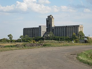
Blagoveshchenka is an urban locality and the administrative center of Blagoveshchensky District of Altai Krai, Russia. Population: 11,626 (2010 Census); 12,416 (2002 Census); 13,600 (1989 Census).
Romanovo is a rural locality and the administrative center of Romanovsky District of Altai Krai, Russia. Population: 5,624 (2010 Census); 6,243 (2002 Census); 6,174 (1989 Census).
Talmenka is an urban locality and the administrative center of Talmensky District of Altai Krai, Russia. Population: 18,814 (2010 Census); 20,016 (2002 Census); 19,720 (1989 Census).
