
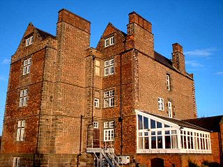
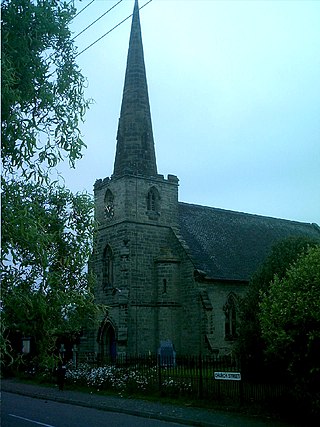
Bretby is a village and civil parish in the south of Derbyshire, England, north of Swadlincote and east of Burton upon Trent, on the border between Derbyshire and Staffordshire. The population of the civil parish as of the 2011 census was 893. The name means "dwelling place of Britons". On the A511 road, there is a secondary settlement, Stanhope Bretby, which was the site of Bretby Colliery.

The National Forest is an environmental project in central England run by The National Forest Company. From the 1990s, 200 square miles (520 km2) of north Leicestershire, south Derbyshire and southeast Staffordshire have been planted in an attempt to blend ancient woodland with newly planted areas to create a new national forest. It stretches from the western outskirts of Leicester in the east to Burton upon Trent in the west, and is planned to link the ancient forests of Needwood and Charnwood.

Aston-on-Trent is a village and civil parish in the South Derbyshire district, in the county of Derbyshire, England. The parish had a population of 1,682 at the 2011 Census. It is adjacent to Weston-on-Trent and near Chellaston, very close to the border with Leicestershire.

Measham is a large village in the North West Leicestershire district in Leicestershire, England, near the Derbyshire, Staffordshire and Warwickshire boundaries. It lies off the A42, 4+1⁄2 miles (7.2 km) south of Ashby de la Zouch, in the National Forest. Historically it was in an exclave of Derbyshire absorbed into Leicestershire in 1897. The name is thought to mean "homestead on the River Mease". The village was once part of Derbyshire before being transferred to Leicestershire.

Melbourne is a market town and civil parish in South Derbyshire, England. It was home to Thomas Cook, and has a street named after him. It is 8 miles (13 km) south of Derby and 2 miles (3 km) from the River Trent. The population of the civil parish at the 2021 Census was 5,264.
Weston-on-Trent is a village and civil parish in the South Derbyshire district of Derbyshire. The population of the civil parish at the 2011 census was 1,239. It is to the north of the River Trent and the Trent and Mersey Canal. Nearby places include Aston-on-Trent, Barrow upon Trent, Castle Donington and Swarkestone.
Ravenstone is a village and former civil parish, now in the parish of Ravenstone with Snibstone, in the North West Leicestershire district, in the county of Leicestershire, England. It is within the National Forest, just off the A511 road between Coalville and Ashby-de-la-Zouch, in 2001 it had a population of 2,149.
Chaddesley Corbett is a village and civil parish in the Wyre Forest District of Worcestershire, England. The Anglican and secular versions of the parish include other named neighbourhoods, once farmsteads or milling places: Bluntington, Brockencote, Mustow Green, Cakebole, Outwood, Harvington, and Drayton.
Hatton is a village and civil parish in South Derbyshire, England. It is 5 miles (8.0 km) north of Burton upon Trent, 10 miles (16 km) south-west of Derby and 24 miles (39 km) south-east of Stoke-on-Trent. The population of the civil parish as of the 2011 census was 2,785. It adjoins Tutbury to the south.
Coton in the Elms is a village and parish in the English county of Derbyshire. At 70 miles (110 km) from the coast, it is one of the furthest places in the United Kingdom from coastal waters. The population of the civil parish as of the 2011 census was 896. It is located 5 miles (8.0 km) southwest of Swadlincote and 6 miles (9.7 km) south of Burton upon Trent.
Stapenhill is a village and civil parish in Burton upon Trent, Staffordshire, England.

Draycott and Church Wilne is a civil parish within the Borough of Erewash, which is in the county of Derbyshire, England. Partially built up and otherwise rural, its population was 3,090 residents in the 2011 census. The parish is 100 miles (160 km) north west of London, 5+1⁄2 miles (8.9 km) south east of the county city of Derby, and 3 miles (4.8 km) west of the nearest market town of Long Eaton. It shares a boundary with the parishes of Breaston, Elvaston, Hopwell, Ockbrook and Borrowash, Risley and Shardlow and Great Wilne.

Foremark is a hamlet and civil parish in the South Derbyshire district of Derbyshire, England. It contains Foremarke Hall, a medieval manor house which now houses Repton Preparatory School; and part of Foremark Reservoir.
Wormhill is a village and civil parish in the High Peak district of Derbyshire, England, situated east by north of Buxton. The population of the civil parish including Peak Dale was 1,020 at the 2011 Census.

Walton-on-Trent is a village within the civil parish of Walton-upon-Trent, in the National Forest in the South Derbyshire district in Derbyshire, England. The population of the civil parish as taken at the 2011 Census was 872.

Linton is a settlement and civil parish in South Derbyshire, England, 5 miles south east of Burton-on-Trent. The population of the civil parish taken at the 2011 Census was 2,303.

Parwich is a village and parish in the Derbyshire Dales, 7 miles north of Ashbourne. In the 2011 census the population of the civil parish was 472.

Sopley is a village and civil parish situated in the New Forest National Park of Hampshire, England. It lies on the old main road from Christchurch to Ringwood, on the east bank of the River Avon. The parish extends east as far as Thorny Hill and borders the parishes of Bransgore and Burton to the south and west respectively. It lies down the road from a small hamlet called Ripley. It includes the hamlets of Shirley, Avon and Ripley. The area is mainly rural with less than 300 dwellings.

Headon cum Upton is a civil parish in the Bassetlaw district, in the county of Nottinghamshire, England. The parish includes the villages of Headon, Upton and the hamlet of Nether Headon. The parish is adjacent to Askham, Gamston, East Drayton, Eaton, Grove, Rampton and Woodbeck, Stokeham and Treswell. In the 2021 census, the parish had a population of 192. The area is 3.5 miles south east of the nearest market town Retford, 26 miles north east of the county town Nottingham and 125 miles north of London. Headon cum Upton shares a parish council with Grove and Stokeham. There are 6 listed buildings in Headon cum Upton.
Nether Headon is a hamlet in Headon cum Upton civil parish, within the Bassetlaw district, of the county of Nottinghamshire, England. It is 3.5 miles south east of the nearest market town Retford, 26 miles north east of the county town Nottingham and 125 miles north of London. The hamlet is adjacent to the villages of Upton, Headon, East Drayton, Eaton, Grove, Woodbeck and Stokeham. In 2011 the parish, together with Stokeham had a population of 253.


