Rother Link

Last updated

Rother Link
RiverRotherNearRiverDon.jpg
The River Rother just before it joins the River Don at Rotherham
Specifications
Locksunknown
StatusProposed river navigation
Geography
Start pointRother Valley Country Park
End point Rotherham
Connects to Chesterfield Canal, River Don Navigation
River Rother Link
BSicon uSTRq.svg
BSicon uFABZq+lr.svg
BSicon uSTRq.svg
River Don Navigation
BSicon uexFABZq+lr.svg
BSicon uexSTRr.svg
Junction with River Don
BSicon uexSKRZ-Au.svg
A6021, Central Rotherham
BSicon uexSKRZ-Au.svg
A630 Centenary Way
BSicon uexSKRZ-Au.svg
A631 Bawtry Road
BSicon uxSLUICEbr.svg
Canklow regulator
BSicon uexSKRZ-Au.svg
A630 Rother Way
BSicon uexSKRZ-Bu.svg
M1 motorway
BSicon uexSKRZ-Yu.svg
Treeton Lane
BSicon uxWEIRf.svg
Orgreave weir
BSicon uexSKRZ-Yu.svg
Sheffield Road
BSicon uxSLUICEbr.svg
Woodhouse Mill regulator
BSicon uxmKRZu.svg
Sheffield - Lincoln Railway
BSicon uexSKRZ-Au.svg
A57 Handsworth Bypass
BSicon uexSKRZ-Yu.svg
Rotherham Road, Beighton
BSicon uxWEIRf.svg
Beighton weir
BSicon uxmKRZu.svg
Rotherham - Chesterfield Railway
BSicon uexnSTR.svg
BSicon uexSTRl.svg
BSicon uexSTR+r.svg
BSicon uexDOCKS.svg
BSicon uexSTR.svg
Rother Valley Country Park
BSicon uexDOCKSa.svg
BSicon uexSTR.svg
BSicon uexSTR+l.svg
To Norwood locks
BSicon uexDOCKSm.svg
BSicon uxSLUICEbr.svg
BSicon uLSTR+l.svg
BSicon ABZmgr exu+g.svg
Meadowgate Regulator
BSicon uexDOCKSe.svg
BSicon uexSTR.svg
BSicon uLLOCKSu.svg
BSicon gSTR.svg
New locks
BSicon uexnSTR.svg
BSicon uexSTR+l.svg
BSicon uexSTRr.svg
BSicon uLSTRl.svg
BSicon uexDOCKS.svg
BSicon gSTR.svg
New link to Nethermoor Lake
BSicon uexSTR.svg
BSicon uLLOCKSd.svg
BSicon gSTR.svg
New locks
BSicon uexSTR.svg
BSicon gmABZg+l exu+.svg
BSicon gSTRr.svg
BSicon uexSTR.svg
BSicon uexSTR.svg
Killamarsh section
BSicon uexCONTf.svg
BSicon uexCONTf.svg
Chesterfield Canal

The Rother Link is a planned English canal that would connect the Chesterfield Canal at Killamarsh, via the River Rother through to the Sheffield and South Yorkshire Navigation, thus creating a new cruising ring and encouraging boats to visit the Chesterfield Canal. [1] [2] [3]

Contents

Proposals

The Rother Link was first suggested in early 1995, when the Chesterfield Canal Society submitted their proposal to the National Rivers Authority for the conversion to navigable status of the 6-mile (9.7 km) section of the River Rother from Killamarsh to Rotherham. [4] The link has been adopted as an official goal by the Chesterfield Canal Partnership, a group of Councils at District and County level, working together with British Waterways and the Chesterfield Canal Trust. The councils consist of Derbyshire County Council, Chesterfield Borough Council, N E Derbyshire District Council, Rotherham Metropolitan Borough Council, Bassettlaw District Council and Nottinghamshire County Council. [5]

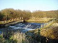
While the connection between the Chesterfield Canal and the River Rother would have been difficult to achieve when the canal followed its original route, the need to create a diversion around housing development in Killamarsh, which has destroyed the former course, makes it much simpler. The current plans for the Chesterfield Canal reinstatement envisage the canal turning to the north and dropping down through five locks to reach Nethermoor Lake, one of four lakes that are part of the Rother Valley Country Park. From the far end of the lake, another six locks would return the level to the existing channel near Norwood. There is a relatively easy route from the lake to the Rother, which would probably require a flood lock for protection. [6]

The route diagram shows existing roads and railways which cross the River Rother between the Rother Valley Country Park and Rotherham. As there is a drop of around 46 feet (14 m) between these two points, several locks would be required, and the waterway would consist of a number of river sections with cuts to accommodate the locks. In 2016 it was suggested that around six locks would be required, and that they would be broad locks, at 14 feet (4.3 m) by 72 feet (22 m). [6] Much of the route is already canalised, with the banks protected by concrete and steel piling. If the project goes ahead, old washlands and waterlogged wooded carrs would be reinstated, features that were lost when the present flood control measures were installed. [7]

The route of the river is quite easy to follow, as the Trans Pennine Trail runs along the river bank from Rotherham to the A631 bridge, and then follows the valley to Rother Valley Country Park, on its way to Chesterfield. The Trans Pennine Trail is a long distance footpath, connecting Liverpool, Leeds, Hull and Chesterfield, and is suitable for walking and cycling, with some sections suitable for horse riding. [8]

Benefits

As with similar canal schemes, the Rother Valley Link would bring economic benefits to the region, which are estimated to be around £2.4 million in visitor spending per year. The link would also mean that the Chesterfield Canal was more easily accessible to boaters for which the transit of the tidal River Trent is daunting. A further benefit for walkers, cyclists and boaters would be the creation of a South Yorkshire Ring, which would be around 108 miles (174 km) long. This would follow the new link from the Rother Valley Country Park to Rotherham, pass down the River Don Navigation to Bramwith, along the Stainforth and Keadby Canal to Keadby, up the River Trent to West Stockwith, and back along the Chesterfield Canal to the country park. [7]

Precursors

The idea of a link between the Chesterfield Canal and the River Don system is not new. Benjamin Outram, reporting to those planning the Sheffield Canal in 1793 proposed an extension to his Eckington, Beighton, Attercliffe and Tinsley route, which would use five narrow locks to join up with the Chesterfield Canal, at a cost of £4,175. Neither the main route, nor the extension were pursued. In 1810, a proposal to link Rotherham to the Chesterfield Canal was made by Richard Gresley. This was the North Eastern Junction Canal, and envisaged a link from the Chesterfield Canal to the Cromford Canal as well, but the scheme met with little enthusiasm. [9]

In 1814, the Sheffield Canal promoters were considering two schemes, one to the north of the River Don, and one to the south, and the southern route was preferred because it would make a future link to the Chesterfield Canal easier to construct. [10] The idea was revived in June 1832, with a proposal for a Sheffield and Chesterfield Junction Canal, which would run from the top of the locks at Sheffield to Killamarsh forge on the Chesterfield Canal. The 7.7-mile (12.4 km) canal, requiring two locks, was costed at £46,204 by the engineer Joseph Burke. A further report was made in October 1832 by George Leather, who included some improvements and revised the cost to £75,870. With no interest being shown by the River Don Navigation, the project foundered due to the failure to raise the necessary finance. [11]

Route

Map all coordinates using: OpenStreetMap  
Download coordinates as: KML

See also

Bibliography

Related Research Articles

Calder and Hebble Navigation

The Calder and Hebble Navigation is a broad inland waterway, with locks and bridgeholes that are suitable for 14-foot-wide (4.3 m) boats, in West Yorkshire, England. Construction to improve the River Calder and the River Hebble began in 1759, and the initial scheme, which included 5.7 miles (9.2 km) of new cuts, was completed in 1770 and has remained navigable since it was opened. Significant improvements were made, including the Salterhebble branch to Halifax, opened in 1828, and ever-longer cuts to bypass river sections. Trade was assisted by the opening of the Rochdale Canal in 1804, which provided a through route from Sowerby Bridge to Manchester. There were plans to abandon the river sections completely in the 1830s, but these were modified as the needs of mill owners and other riparian landowners were recognised.

Aire and Calder Navigation Canal in West Yorkshire, England

The Aire and Calder Navigation is the canalised section of the Rivers Aire and Calder in West Yorkshire, England. The first improvements to the rivers above Knottingley were completed in 1704 when the Aire was made navigable to Leeds and the Calder to Wakefield, by the construction of 16 locks. Lock sizes were increased several times, as was the depth of water, to enable larger boats to use the system. The Aire below Haddlesey was bypassed by the opening of the Selby Canal in 1778. A canal from Knottingley to the new docks and new town at Goole provided a much shorter route to the River Ouse from 1826. The New Junction Canal was constructed in 1905, to link the system to the River Don Navigation, by then part of the Sheffield and South Yorkshire Navigation.

Sheffield and South Yorkshire Navigation

The Sheffield and South Yorkshire Navigation (S&SY) is a system of navigable inland waterways in South Yorkshire and Lincolnshire, England.

River Don, Yorkshire River in South Yorkshire, England

The River Don is a river in South Yorkshire and the East Riding of Yorkshire, England. It rises in the Pennines, west of Dunford Bridge, and flows for 70 miles (110 km) eastwards, through the Don Valley, via Penistone, Sheffield, Rotherham, Mexborough, Conisbrough, Doncaster and Stainforth. It originally joined the Trent, but was re-engineered by Cornelius Vermuyden as the Dutch River in the 1620s, and now joins the River Ouse at Goole. Don Valley is a UK parliamentary constituency near the Doncaster stretch of the river.

Chesterfield Canal

The Chesterfield Canal is a narrow canal in the East Midlands of England and it is known locally as 'Cuckoo Dyke'. It was one of the last of the canals designed by James Brindley, who died while it was being constructed. It was opened in 1777 and ran for 46 miles (74 km) from the River Trent at West Stockwith, Nottinghamshire to Chesterfield, Derbyshire, passing through the Norwood Tunnel at Kiveton Park, at the time one of the longest tunnels on the British canal system. The canal was built to export coal, limestone, and lead from Derbyshire, iron from Chesterfield, and corn, deals, timber, groceries and general merchandise into Derbyshire. The stone for the Palace of Westminster was quarried in North Anston, Rotherham, and transported via the canal.

Trans Pennine Trail

The Trans Pennine Trail is a long-distance path running from coast to coast across Northern England entirely on surfaced paths and using only gentle gradients. It forms part of European walking route E8 and is part of the National Cycle Network as Route 62.

River Rother, South Yorkshire River in South Yorkshire, England

The River Rother, a waterway in the northern midlands of England, gives its name to the town of Rotherham and to the Rother Valley parliamentary constituency. It rises near Clay Cross in Derbyshire and flows in a generally northwards direction through the centre of Chesterfield, where it feeds the Chesterfield Canal, and on through the Rother Valley Country Park and several districts of Sheffield before joining the River Don at Rotherham in Yorkshire.

Dearne and Dove Canal Canal in South Yorkshire, England

The Dearne and Dove Canal ran for almost ten miles through South Yorkshire, England from Swinton to Barnsley through nineteen locks, rising 127 feet (39 m). The canal also had two short branches, the Worsbrough branch and the Elsecar branch, both about two miles long with reservoirs at the head of each. The Elsecar branch also has another six locks. The only tunnel was bypassed by a cutting in 1840.

Rochdale Canal

The Rochdale Canal is in Northern England, between Manchester and Sowerby Bridge, part of the connected system of the canals of Great Britain. Its name refers to the town of Rochdale through which it passes.

Killamarsh Human settlement in England

Killamarsh is a town and civil parish in North East Derbyshire, England, bordering Sheffield and South Yorkshire to the North West. Killamarsh is surrounded by, in a clockwise direction from the north, Rother Valley Country Park, Wales, Kiveton, Woodall, Harthill, Barlborough, Spinkhill, Renishaw, Eckington, and the Sheffield suburbs of Oxclose, Halfway and Holbrook.

Sheffield & Tinsley Canal

The Sheffield & Tinsley Canal is a canal in the City of Sheffield, England. It runs 3.9 miles (6.3 km) from Tinsley, where it leaves the River Don, to the Sheffield Canal Basin in the city centre, passing through 11 locks. The maximum craft length that can navigate this lock system is 61 feet 6 inches (18.75 m) with a beam of 15 feet 6 inches (4.72 m).

New Junction Canal

The New Junction Canal is a canal in South Yorkshire, England. It is part of the Sheffield and South Yorkshire Navigation (S&SYN), although it was jointly funded by the Aire and Calder Navigation, and was opened in 1905. It links the River Don Navigation and the Stainforth and Keadby Canal with the Aire and Calder Navigation. It is completely straight, and was the last canal built in England for commercial purposes.

Yorkshire Ring

The Yorkshire Ring is a canal ring in South and West Yorkshire, England. It was completed in 1905 with the construction of the New Junction Canal. It lasted for under thirty years before the closure of part of the Dearne and Dove Canal and subsequently the complete Barnsley Canal. Both these canals are currently under restoration.

Transport in Sheffield

Transport in Sheffield, England is developed around the city's unusual topography and medieval street plan. Once an isolated town, the transport infrastructure changed dramatically in the 19th and 20th centuries. The city now has road and rail links with the rest of the country, and road, bus and trams for local transport.

Blackburn Brook

The Blackburn Brook is a stream in Sheffield, South Yorkshire, England which flows through the Blackburn Valley along the M1 and Ecclesfield Road and joins the River Don near the Meadowhall shopping centre. Downstream from the A61 road at Chapeltown the Blackburn Brook is defined as a main river by the Environment Agency, which requires new building development to be at least 8m from the bank side as a flood defence measure and to allow access to the watercourse for maintenance.

Stainforth and Keadby Canal

The Stainforth and Keadby Canal is a navigable canal in South Yorkshire and Lincolnshire, England. It connects the River Don Navigation at Bramwith to the River Trent at Keadby, by way of Stainforth, Thorne and Ealand, near Crowle. It opened in 1802, passed into the control of the River Don Navigation in 1849, and within a year was controlled by the first of several railway companies. It became part of the Sheffield and South Yorkshire Navigation, an attempt to remove several canals from railway control, in 1895. There were plans to upgrade it to take larger barges and to improve the port facilities at Keadby, but the completion of the New Junction Canal in 1905 made this unnecessary, as Goole could easily be reached and was already a thriving port.

River Don Navigation Waterway navigation in South Yorkshire, England

The River Don Navigation was the result of early efforts to make the River Don in South Yorkshire, England, navigable between Fishlake and Sheffield. The Dutch engineer Cornelius Vermuyden had re-routed the mouth of the river in 1626, to improve drainage, and the new works included provision for navigation, but the scheme did not solve the problem of flooding, and the Dutch River was cut in 1635 to link the new channel to Goole. The first Act of Parliament to improve navigation on the river was obtained in 1726, by a group of Cutlers based in Sheffield; the Corporation of Doncaster obtained an Act in the following year for improvements to the lower river. Locks and lock cuts were built, and, by 1751, the river was navigable to Tinsley.

Chesterfield Canal Trust

The Chesterfield Canal Trust Limited is a waterway society and charitable company which campaigns for and undertakes various activities related to the Chesterfield Canal, which runs from Chesterfield in Derbyshire, England to the River Trent at West Stockwith.

Beighton Junction is a set of railway junctions near Beighton on the border between Derbyshire and South Yorkshire, England.

References

  1. "Chesterfield Canal Trust: News 26 June 2003". Archived from the original on 24 November 2003. Retrieved 21 December 2008.
  2. "Chesterfield Canal Trust: Develop Manager's Reports: Forward to a Rother Valley Link". Archived from the original on 3 May 2008. Retrieved 21 December 2008.
  3. "Inland Waterways Association (Under restoration)". Archived from the original on 14 October 2010. Retrieved 4 September 2010.
  4. Squires 2008, p. 136.
  5. "Chesterfield Canal Partnership". Archived from the original on 3 March 2016. Retrieved 21 December 2008.
  6. 1 2 Denny 2016, p. 92.
  7. 1 2 Denny 2016, p. 93.
  8. "Welcome to the Trans Pennine Trail". Trans Pennine Trail. Archived from the original on 16 June 2017. Retrieved 29 April 2009.
  9. Hadfield 1973 , pp. 266–270
  10. Hadfield 1973 , pp. 270–271
  11. Hadfield 1973 , p. 273

Commons-logo.svg Media related to Rother Link at Wikimedia Commons