New Junction Canal

Last updated

New Junction Canal
NewJunctionDonAqueductGates.jpg
Guillotine gates protect the canal from the River Don
Specifications
Maximum boat length 215 ft 0 in (65.53 m)
Maximum boat beam 22 ft 6 in (6.86 m)
Locks1
StatusOperational
Navigation authority Canal and River Trust
History
Original ownerAire and Calder Navigation, Sheffield and South Yorkshire Navigation Co
Date of act1891
Date of first use1905
Geography
Start pointRiver Don
End pointAire and Calder
Connects to Aire and Calder Navigation, River Don Navigation
New Junction Canal
BSicon uFABZq+lr.svg
0.0m
Aire and Calder Navigation
BSicon ueKRZo.svg
0.2m
Went aqueduct
BSicon uKRZuyba.svg
1.0m
Sykehouse lift bridge
BSicon uKRZuyba.svg
1.5m
Kirk Lane lift bridge
BSicon uKRZuysw.svg
1.8m
Sykehouse swing bridge
BSicon uLock3.svg
1.8m
Sykehouse Lock
BSicon uKRZuysw.svg
2.4m
Smallhedge swing bridge
BSicon uKRZuyba.svg
3.5m
Kirkhouse Green lift bridge
BSicon uKRZuyba.svg
4.2m
Top Lane lift bridge
BSicon uKRZuysw.svg
4.6m
Low Lane swing bridge
BSicon uexSTR+l.svg
BSicon ueKRZo.svg
BSicon uexSTRq.svg
5.1m
River Don aqueduct
BSicon uexSTR.svg
BSicon uABZg+l.svg
BSicon uLockl.svg
5.5m
Stainforth and Keadby Canal
BSicon uexSTR.svg
BSicon uSTR+GRZq.svg
Sheffield and South Yorkshire
BSicon uexSTR.svg
BSicon uSTR.svg
Navigation
Sykehouse Lock, with a swing bridge crossing its centre NewJunctionSykehouseLock.jpg
Sykehouse Lock, with a swing bridge crossing its centre

The New Junction Canal is a canal in South Yorkshire, England. It is part of the Sheffield and South Yorkshire Navigation (S&SYN), although it was jointly funded by the Aire and Calder Navigation, and was opened in 1905. It links the River Don Navigation and the Stainforth and Keadby Canal with the Aire and Calder Navigation (Knottingley Canal). It is completely straight, and was the last canal built in England for commercial purposes.

Contents

The canal has one lock, which was sized to allow the compartment boats of the Aire and Calder to use it, but the owning company failed to raise enough money to upgrade the River Don Navigation beyond, and Long Sandall lock prevented working of such boats through to Doncaster until it was rebuilt in 1959. There is still some commercial traffic on the canal, but most use is now by leisure boaters. One notable feature is the aqueduct over the River Don which is protected by large guillotine gates, which can be lowered when the Don is in spate, to prevent the surrounding countryside from being flooded.

History

The New Junction Canal was conceived at a time when there was dissatisfaction with the state of the waterways in Sheffield and Doncaster, which were then under the ownership of the Manchester, Sheffield and Lincolnshire Railway. Steam-powered boats were still prohibited from using the waterways in 1888, even though they had been in use on the neighbouring Aire and Calder Navigation for over 50 years, and the railway company had set rates for using the canal considerably higher than those for using the railway. The President of the Sheffield Chamber of Commerce invited the engineer Charles Hawksley and B. P. Broomhead, an influential Sheffield solicitor, to a meeting of the Chamber on 16 August 1888, at which he outlined the situation. A committee was appointed, which met on 20 August, and decided that a new independent canal was needed to connect Sheffield, Rotherham and Doncaster to the sea, to maintain the profitability of the local coalfields. [1]

By October, a report had been produced, which suggested that the locks on the canal from Sheffield to Keadby were too small, and that the waterway could be greatly improved by building new locks besides the existing ones, capable of holding boats which could carry 300 or 500 tons. Believing that such locks could be built without disrupting traffic, the estimated costs of the works were £1 million, in addition to which the existing waterways would need to be acquired. The Sheffield and South Yorkshire Canal Company Ltd was registered on 15 November 1888, with the aim of obtaining an Act of Parliament to authorise this work. The Act was passed on 26 August 1889, which created the Sheffield and South Yorkshire Navigation Co., who had powers to raise £1.5 million, and to buy the four South Yorkshire canals, consisting of the Sheffield Canal, the River Don Navigation, the Stainforth and Keadby Canal and the Dearne and Dove Canal. They had nine months to negotiate with the railway owners, and could resort to compulsory purchase after that. In order to demonstrate their resolve, £20,000 had to be deposited within six months of the date of the Act. [2]

By this stage, the plan was to enlarge the waterways to enable 300 or 400 ton barges to navigate, but also to make the locks suitable for compartment boat trains, as used on the Aire and Calder. New facilities would be built at Keadby, where the canal joined the River Trent, so that coal could be trans-shipped to larger vessels. Negotiations with the railway company began, but they refused to co-operate, instead waiting nine months until the compulsory purchase option was possible, and then taking court action against the Canal company once the purchase order was served. The Canal company sought assistance from the Court of the Railway and Canal Commission, who ruled in their favour, and the railway company finally produced the details of their ownership in early 1891. [3]

The concept of using compartment boats led to discussions with the Aire and Calder Navigation Company, as a result of which it was decided to abandon the plan to develop Keadby, and instead use the existing port facilities at Goole. As the Sheffield and South Yorkshire Company had yet to take control of any canals, an agreement was negotiated, which would see the Aire and Calder obtaining an Act of Parliament to authorise construction of a 5.5-mile (8.9 km) straight canal from Bramwith on the River Don to a point some 7 miles (11 km) above Goole. The Act was obtained on 28 July 1891, and specified that the S&SYN could become joint owners and subscribers, once they had acquired the four waterways from the railway company. Transfer of the canals was finally agreed on 31 July 1894, at a cost to the canal company of £1.14 million, of which £600,000 was to be paid in cash. The company managed to raise £625,000 through the issue of preference shares, but the rest of the purchase price was held as ordinary shares by the railway company, who were then able to appoint five of the ten directors. As a consequence of continued railway involvement, the Aire and Calder did not invest in the new company, which took control of the four waterways on 1 March 1895. The Aire and Calder, meanwhile, had not started to build the New Junction Canal, but they had extended the time allowed to purchase land for its construction through another Act of Parliament. [4]

The new company struggled to raise the finance for the New Junction construction, and for improvements to the River Don Navigation, to allow larger boats to use it. The canal was completed on 2 January 1905, at a total cost of £300,000, shared between the Sheffield and South Yorkshire and the Aire and Calder companies. [5] It was the last canal to be built in England for commercial purposes. [6]

Operation

The canal helped to increase traffic on the River Don from 835,982 tons to 961,774 tons between 1905 and 1913. Income from tolls over the same period rose from £48,981 to £53,586. Although the River Don was straightened at Doncaster in 1905 and at Sprotborough in 1907, traffic on the New Junction canal was hindered by the size of the locks on the river. Doncaster lock was extended in 1909 and 1910, but although trains of 17 compartment boats could then use both Sykehouse and Doncaster locks, they had to be split up at Long Sandall lock, which was between the two, as they could only pass through it three at a time. Traffic to Hatfield Main colliery was improved between 1930 and 1932, when Bramwith lock, the first on the Stainforth and Keady Canal, was lengthened to allow compartment boats from the New Junction to reach it. The work, which included a colliery lay-by, cost £20,000. Doncaster Corporation paid most of the cost of straightening the river there and building a 300-foot (91 m) wharf and warehouse, which opened in 1934. [7]

Further improvements had to wait until after the canals were nationalised in 1948. Long Sandall lock was lengthened and widened to 215 by 22 feet (65.5 by 6.7 m) in 1959, enabling compartment boats to work through to Doncaster and Hexthorpe without having to be split for the first time. [8] Although traffic is much reduced, there is still some commercial activity on the canal. [9]

Features

The canal overflowing the Don aqueduct into the river below NewJunctionCanalDonAqueduct.JPG
The canal overflowing the Don aqueduct into the river below

The canal is straight for its entire length, and the surrounding countryside is relatively flat. It has one lock, five swing or lift bridges and is carried across two aqueducts. At its northern end it crosses the River Went, while at its southern end it crosses the River Don. The River Don aqueduct looks precarious, as the canal regularly overflows the eastern side of the structure, and there only appears to be railings preventing the boats from falling down into the river below. Both ends of the aqueduct are protected by large guillotine gates, [10] which are there to prevent the river overflowing the canal when it is in spate, and flooding the surrounding countryside.

For the boater, the most notable feature is the complicated operation of Sykehouse Lock. The lock is automated but the control system is disabled until the manually operated swing bridge over the top of it has been opened. [10]

The region through which the canal flows is sparsely populated, as there are no major towns, and just two main villages. The civil parish of Sykehouse, which includes a number of outlying settlements, straddles the northern end of the canal, and Kirk Bramwith is at the southern end. For much of its length, the towpath forms part of the route for the Trans Pennine Trail which joins it at Top Lane lift bridge, crosses to the east bank at Sykehouse lock, and leaves at Sykehouse lift bridge. [11]

Points of interest

See also

Bibliography

Related Research Articles

<span class="mw-page-title-main">Calder and Hebble Navigation</span> Inland waterway in West Yorkshire, England

The Calder and Hebble Navigation is a broad inland waterway, with locks and bridgeholes that are suitable for 14-foot-wide (4.3 m) boats, in West Yorkshire, England. Construction to improve the River Calder and the River Hebble began in 1759, and the initial scheme, which included 5.7 miles (9.2 km) of new cuts, was completed in 1770 and has remained navigable since it was opened. Significant improvements were made, including the Salterhebble branch to Halifax, opened in 1828, and ever-longer cuts to bypass river sections. Trade was assisted by the opening of the Rochdale Canal in 1804, which provided a through route from Sowerby Bridge to Manchester. There were plans to abandon the river sections completely in the 1830s, but these were modified as the needs of mill owners and other riparian landowners were recognised.

<span class="mw-page-title-main">Aire and Calder Navigation</span> Canal in West Yorkshire, England

The Aire and Calder Navigation is the canalised section of the Rivers Aire and Calder in West Yorkshire, England. The first improvements to the rivers above Knottingley were completed in 1704 when the Aire was made navigable to Leeds and the Calder to Wakefield, by the construction of 16 locks. Lock sizes were increased several times, as was the depth of water, to enable larger boats to use the system. The Aire below Haddlesey was bypassed by the opening of the Selby Canal in 1778. A canal from Knottingley to the new docks and new town at Goole provided a much shorter route to the River Ouse from 1826. The New Junction Canal was constructed in 1905, to link the system to the River Don Navigation, by then part of the Sheffield and South Yorkshire Navigation.

<span class="mw-page-title-main">Sheffield and South Yorkshire Navigation</span> System of navigable inland waterways in South Yorkshire and Lincolnshire, England

The Sheffield and South Yorkshire Navigation (S&SY) is a system of navigable inland waterways in South Yorkshire and Lincolnshire, England.

<span class="mw-page-title-main">River Don, Yorkshire</span> River in South Yorkshire and the East Riding of Yorkshire, England

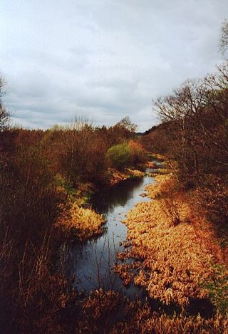
The River Don is a river in South Yorkshire and the East Riding of Yorkshire, England. It rises in the Pennines, west of Dunford Bridge, and flows for 69 miles (111 km) eastwards, through the Don Valley, via Penistone, Sheffield, Rotherham, Mexborough, Conisbrough, Doncaster and Stainforth. It originally joined the Trent, but was re-engineered by Cornelius Vermuyden as the Dutch River in the 1620s, and now joins the River Ouse at Goole. Don Valley is a UK parliamentary constituency near the Doncaster stretch of the river.

<span class="mw-page-title-main">History of the British canal system</span> Building, use, decline and restoration of artificial waterways in the United Kingdom

The canal network of the United Kingdom played a vital role in the Industrial Revolution. The UK was the first country to develop a nationwide canal network which, at its peak, expanded to nearly 4,000 miles in length. The canals allowed raw materials to be transported to a place of manufacture, and finished goods to be transported to consumers, more quickly and cheaply than by a land based route. The canal network was extensive and included feats of civil engineering such as the Anderton Boat Lift, the Manchester Ship Canal, the Worsley Navigable Levels and the Pontcysyllte Aqueduct.

<span class="mw-page-title-main">Barnsley Canal</span> Canal that ran from Barnby Basin, through Barnsley, South Yorkshire, England

The Barnsley Canal is a canal that ran from Barnby Basin, through Barnsley, South Yorkshire, England to a junction with the Aire and Calder Navigation near Wakefield, West Yorkshire. It was built in the 1790s, to provide a transport link from coal reserves at Barnsley to a wider market. Both the Aire and Calder Navigation and the River Don Navigation took a keen interest in the project, the former buying many of the initial shares, and the latter constructing the Dearne and Dove Canal to link the canal to their waterway. Water supply issues meant that the Aire and Calder proposed pumping all of the water for the canal from the River Calder, using steam pumps, but a reservoir was built at Cold Hiendley instead, increasing the construction costs, but reducing the running costs. The canal as built was 14.5 miles (23.3 km) long and included 15 locks.

<span class="mw-page-title-main">Canals of the United Kingdom</span> Network of inland waterways

The canals of the United Kingdom are a major part of the network of inland waterways in the United Kingdom. They have a varied history, from use for irrigation and transport, through becoming the focus of the Industrial Revolution, to today's role of recreational boating. Despite a period of abandonment, today the canal system in the United Kingdom is again increasing in use, with abandoned and derelict canals being reopened, and the construction of some new routes. Canals in England and Wales are maintained by navigation authorities. The biggest navigation authorities are the Canal & River Trust and the Environment Agency, but other canals are managed by companies, local authorities or charitable trusts.

<span class="mw-page-title-main">Huddersfield Broad Canal</span> Navigation canal in West Yorkshire, England

The Huddersfield Broad Canal or Sir John Ramsden's Canal, is a wide-locked navigable canal in West Yorkshire in northern England. The waterway is 3.75 miles (6 km) long and has 9 wide locks. It follows the valley of the River Colne and connects the Calder and Hebble Navigation at Cooper Bridge junction with the Huddersfield Narrow Canal near Aspley Basin in Huddersfield.

<span class="mw-page-title-main">Dearne and Dove Canal</span> Canal in South Yorkshire, England

The Dearne and Dove Canal ran for almost ten miles through South Yorkshire, England from Swinton to Barnsley through nineteen locks, rising 127 feet (39 m). The canal also had two short branches, the Worsbrough branch and the Elsecar branch, both about two miles long with reservoirs at the head of each. The Elsecar branch also has another six locks. The only tunnel was bypassed by a cutting in 1840.

<span class="mw-page-title-main">Rochdale Canal</span> Trans-Pennine navigable channel in northern England

The Rochdale Canal is in Northern England, between Manchester and Sowerby Bridge, part of the connected system of the canals of Great Britain. Its name refers to the town of Rochdale through which it passes.

<span class="mw-page-title-main">Sheffield & Tinsley Canal</span> United Kingdom legislation

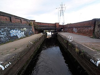
The Sheffield & Tinsley Canal is a canal in the City of Sheffield, England. It runs 3.9 miles (6.3 km) from Tinsley, where it leaves the River Don, to the Sheffield Canal Basin in the city centre, passing through 11 locks. The maximum craft length that can navigate this lock system is 61 feet 6 inches (18.75 m) with a beam of 15 feet 6 inches (4.72 m).

<span class="mw-page-title-main">Yorkshire Ring</span>

The Yorkshire Ring is a canal ring in South and West Yorkshire, England. It was completed in 1905 with the construction of the New Junction Canal. It lasted for under thirty years before the closure of part of the Dearne and Dove Canal and subsequently the complete Barnsley Canal. Both these canals are currently under restoration.

<span class="mw-page-title-main">Stainforth and Keadby Canal</span> Canal in Yorkshire and Lincolnshire, England

The Stainforth and Keadby Canal is a navigable canal in South Yorkshire and Lincolnshire, England. It connects the River Don Navigation at Bramwith to the River Trent at Keadby, by way of Stainforth, Thorne and Ealand, near Crowle. It opened in 1802, passed into the control of the River Don Navigation in 1849, and within a year was controlled by the first of several railway companies. It became part of the Sheffield and South Yorkshire Navigation, an attempt to remove several canals from railway control, in 1895. There were plans to upgrade it to take larger barges and to improve the port facilities at Keadby, but the completion of the New Junction Canal in 1905 made this unnecessary, as Goole could easily be reached and was already a thriving port.

The South Yorkshire Railway was a railway company with lines in the West Riding of Yorkshire, England.

<span class="mw-page-title-main">Selby Canal</span> Canal with 2 locks in Yorkshire, England

The Selby Canal is a 6-mile (9.7 km) canal with 2 locks which bypasses the lower reaches of the River Aire in Yorkshire, England, from the village of West Haddlesey to the town of Selby where it joins the River Ouse. It opened in 1778, and provided the main outlet for the Aire and Calder Navigation until 1826, when it was bypassed by a new cut from Ferrybridge to Goole. Selby steadily declined after that, although traffic to York still used the canal.

<span class="mw-page-title-main">Rother Link</span>

The Rother Link is a planned English canal that would connect the Chesterfield Canal at Killamarsh, via the River Rother through to the Sheffield and South Yorkshire Navigation, thus creating a new cruising ring and encouraging boats to visit the Chesterfield Canal.

<span class="mw-page-title-main">South Pennine Ring</span>

The South Pennine Ring is an English canal ring which crosses the Pennines between Manchester and Huddersfield. It covers parts of five canals, and includes passage through the longest canal tunnel in Britain. It has only been possible to cruise it since 2002, when restoration of the Huddersfield Narrow Canal provided the return route across the Pennines.

<span class="mw-page-title-main">North Pennine Ring</span>

The North Pennine Ring is a canal ring which crosses the Pennines between Manchester, Leeds and Castleford. It follows parts of five canals, and shares much of its route with the Outer Pennine Ring, which uses a different route for the southern crossing of the Pennines.

<span class="mw-page-title-main">Outer Pennine Ring</span>

The Outer Pennine Ring is an English canal ring which crosses the Pennines between Manchester, Leeds and Castleford. Its route follows parts of eight canals, and includes the longest canal tunnel in England. The ring was completed in 2001, with the opening of the Huddersfield Narrow Canal. Much of the route is shared with the North Pennine Ring, which crosses the Pennines by a different route on the southern leg.

<span class="mw-page-title-main">River Don Navigation</span> Waterway navigation in South Yorkshire, England

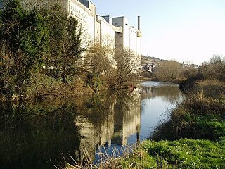
The River Don Navigation was the result of early efforts to make the River Don in South Yorkshire, England, navigable between Fishlake and Sheffield. The Dutch engineer Cornelius Vermuyden had re-routed the mouth of the river in 1626, to improve drainage, and the new works included provision for navigation, but the scheme did not solve the problem of flooding, and the Dutch River was cut in 1635 to link the new channel to Goole. The first Act of Parliament to improve navigation on the river was obtained in 1726, by a group of Cutlers based in Sheffield; the Corporation of Doncaster obtained an Act in the following year for improvements to the lower river. Locks and lock cuts were built and by 1751 the river was navigable to Tinsley.

References

  1. Hadfield 1973 , pp. 415–416
  2. Hadfield 1973 , pp. 416–417
  3. Hadfield 1973 , pp. 417–418
  4. Hadfield 1973 , pp. 418–419
  5. Hadfield 1973 , pp. 419–420
  6. Cumberlidge 2009 , p. 268
  7. Hadfield 1973 , pp. 420–425
  8. Hadfield 1973 , pp. 426–427
  9. Cumberlidge 2009 , p. 202
  10. 1 2 Nicholson 2006 , pp. 24–25
  11. Ordnance Survey, 1:50,000 map
Canals on the Yorkshire Ring - anticlockwise from the north