The Denver and Rio Grande Western Railroad, often shortened to Rio Grande, D&RG or D&RGW, formerly the Denver & Rio Grande Railroad, was an American Class I railroad company. The railroad started as a 3 ft narrow-gauge line running south from Denver, Colorado, in 1870. It served mainly as a transcontinental bridge line between Denver and Salt Lake City, Utah. The Rio Grande was also a major origin of coal and mineral traffic.

Cañon City is a home rule municipality that is the county seat and the most populous municipality of Fremont County, Colorado, United States. The city population was 17,141 at the 2020 United States Census. Cañon City is the principal city of the Cañon City, CO Micropolitan Statistical Area and is a part of the Front Range Urban Corridor. Cañon City straddles the easterly flowing Arkansas River and is a popular tourist destination for sightseeing, whitewater rafting, and rock climbing. The city is known for its many public parks, fossil discoveries, Skyline Drive, The Royal Gorge railroad, the Royal Gorge, and extensive natural hiking paths. In 1994, the United States Board on Geographic Names approved adding the tilde to the official name of Cañon City, a change from Canon City as the official name in its decisions of 1906 and 1975. It is one of the few U.S. cities to have the Spanish Ñ in its name, others being La Cañada Flintridge, California; Española, New Mexico; Peñasco, New Mexico; and Peñitas, Texas.

Black Canyon of the Gunnison National Park is an American national park located in western Colorado and managed by the National Park Service. There are two primary entrances to the park: the south rim entrance is located 15 miles (24 km) east of Montrose, while the north rim entrance is 11 miles (18 km) south of Crawford and is closed in the winter. The park contains 12 miles (19 km) of the 48-mile-long (77 km) Black Canyon of the Gunnison River. The national park itself contains the deepest and most dramatic section of the canyon, but the canyon continues upstream into Curecanti National Recreation Area and downstream into Gunnison Gorge National Conservation Area. The canyon's name owes itself to the fact that parts of the gorge only receive 33 minutes of sunlight a day, according to Images of America: The Black Canyon of the Gunnison. In the book, author Duane Vandenbusche states, "Several canyons of the American West are longer and some are deeper, but none combines the depth, sheerness, narrowness, darkness, and dread of the Black Canyon."

The Little Colorado River is a tributary of the Colorado River in the U.S. state of Arizona, providing the principal drainage from the Painted Desert region. Together with its major tributary, the Puerco River, it drains an area of about 26,500 square miles (69,000 km2) in eastern Arizona and western New Mexico. Although it stretches almost 340 miles (550 km), only the headwaters and the lowermost reaches flow year-round. Between St. Johns and Cameron, most of the river is a wide, braided wash, only containing water after heavy snowmelt or flash flooding.

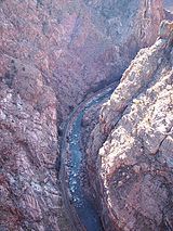
The Royal Gorge Bridge is a tourist attraction near Cañon City, Colorado within Royal Gorge Bridge and Park, a 360-acre (150 ha) amusement park located along the edge of the Royal Gorge around both ends of the bridge. The bridge crosses the gorge 955 feet (291 m) above the Arkansas River and held the record of highest bridge in the world from 1929 until 2001 when it was surpassed by the Liuguanghe Bridge in China. The Royal Gorge Bridge maintained the title of the world's highest suspension bridge until the Beipan River Guanxing Highway Bridge was completed in 2003, also in China. The bridge remains the highest bridge in the United States and was among the ten highest bridges in the world until 2012.

Gore Canyon, elevation 6,985 feet (2,129 m), is a short isolated canyon on the upper Colorado River in southwestern Grand County, Colorado in the United States. Steep and rugged, the approximately 3-mile-long (4.8 km) gorge was carved by the river as it passed the northern end of the Gore Range southwest of Kremmling. The Colorado descends from approximately 7,300 ft (2,200 m) to approximately 7,000 ft (2,100 m) over the length of the canyon. The steep walls ascend approximately 1,000 ft (300 m) on either side. The canyon effectively marks the southwestern end of the Middle Park basin in north-central Colorado.

The known human history of the Grand Canyon area stretches back 10,500 years, when the first evidence of human presence in the area is found. Native Americans have inhabited the Grand Canyon and the area now covered by Grand Canyon National Park for at least the last 4,000 of those years. Ancestral Pueblo peoples, first as the Basketmaker culture and later as the more familiar Pueblo people, developed from the Desert Culture as they became less nomadic and more dependent on agriculture. A similar culture, the Cochimi also lived in the canyon area. Drought in the late 13th century likely caused both groups to move on. Other people followed, including the Paiute, Cerbat, and the Navajo, only to be later forced onto reservations by the United States Government.

Tennessee Pass elevation 10,424 ft (3,177 m) is a high mountain pass in the Rocky Mountains of central Colorado in the United States. The pass was named after Tennessee, the native state of a group of early prospectors.

Ratón Pass is a 7,834 ft (2,388 m) elevation mountain pass on the Colorado–New Mexico border in the western United States. It is located on the eastern side of the Sangre de Cristo Mountains between Trinidad, Colorado and Raton, New Mexico, approximately 180 miles (290 km) northeast of Santa Fe. Ratón is Spanish for "mouse". The pass crosses the line of volcanic mesas that extends east from the Sangre de Cristo Mountains along the state line, and furnishes the most direct land route between the valley of the Arkansas River to the north and the upper valley of the Canadian River, leading toward Santa Fe, to the south. The pass now carries Interstate 25 and railroad tracks.

The New River Gorge National Park and Preserve is a unit of the United States National Park Service (NPS) designed to protect and maintain the New River Gorge in southern West Virginia in the Appalachian Mountains. Established in 1978 as a national river and redesignated in 2020, the park and preserve stretches for 53 miles (85 km) from just downstream of Hinton to Hawks Nest State Park near Ansted.

Railroad Wars were business rivalries between railroad companies, which occurred frequently in American history. Although they were usually little more than legal disputes inside a courtroom, they sometimes turned into armed conflicts. There has been competition between railroad companies since the beginning of railroading in the United States, but violent confrontations were most common in the final quarter of the 19th century, particularly in the Old West.

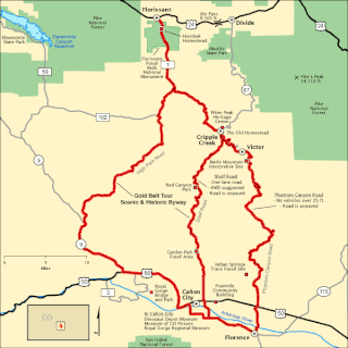
The Gold Belt Tour Scenic and Historic Byway is a National Scenic Byway, a Back Country Byway, and a Colorado Scenic and Historic Byway located in Fremont and Teller counties, Colorado, USA. The byway is named for the Gold Belt mining region. The Cripple Creek Historic District is a National Historic Landmark. The byway forms a three-legged loop with the Phantom Canyon Road, the Shelf Road, and the High Park Road (paved).

Granite is an unincorporated community with a U.S. Post Office in Chaffee County, Colorado, United States. The zip code of Granite is 81228. According to the 2010 census, the population is 116.

The Royal Gorge Route Railroad is a heritage railroad based in Cañon City, Colorado. A 1950s-era train makes daily 2-hour excursion runs from the Santa Fe Depot through the Royal Gorge along a famous section of the former Denver and Rio Grande Western Railroad.

Interstate 70 (I-70) is a mainline route of the Interstate Highway System in the United States connecting Utah and Maryland. The Utah section runs east–west for approximately 232 miles (373 km) across the central part of the state. Richfield is the largest Utah city served by the freeway, which does not serve or connect any urban areas in the state. The freeway was built as part of a system of highways connecting Los Angeles and the Northeastern United States. I-70 was the second attempt to connect southern California to the east coast of the United States via central Utah, the first being a failed attempt to construct a transcontinental railroad. Parts of that effort were reused in the laying out of the route of I-70.

U.S. Route 50 (US 50) is a part of the U.S. Highway System that travels from West Sacramento, California, to Ocean City, Maryland. In the U.S. state of Colorado, US 50 is a major highway crossing through the lower midsection of the state. It connects the Western Slope with the lower Front Range and the Arkansas Valley. The highway serves the areas of Pueblo and Grand Junction as well as many other smaller areas along its corridor. The long-term project to widen the highway from two lanes to a four lane expressway between Grand Junction and Montrose was completed in January 2005. Only about 25% of the remainder of highway 50 in Colorado is four lane highway.

The Curecanti Needle is a 700-ft granite spire located on the Gunnison River in western Colorado. A notable landmark to generations of natives and pioneers, the Needle is located on the southern bank of Morrow Point Reservoir, an impoundment of the Gunnison river between Gunnison and Montrose, Colorado. Used for many years as an advertising symbol for the Denver and Rio Grande Western Railroad, whose narrow-gauge railway famously ran along the northern bank of the river and passed near the Needle, the spire is today part of the Curecanti National Recreation Area, a National Park Service facility that encompasses three impoundments of the Gunnison river, including Morrow Point Reservoir.

Parkdale, is an unincorporated community in Fremont County, Colorado, United States. It is located along U.S. Highway 50 at an elevation of 5,732 feet (1,747 m).

Grape Creek is a tributary of the Arkansas River that flows through Custer and Fremont counties in South-Central Colorado. The creek drains much of the Wet Mountain Valley, located between the Sangre de Cristo Mountains and the Wet Mountains in Custer County.


